Collegedale Municipal Airport is a city-owned, public-use airport located two nautical miles (4 km) southeast of the central business district of the Collegedale, a city in Hamilton County, Tennessee, United States.
Taunton Municipal Airport, also known as King Field, is a public use airport located three nautical miles (6 km) east of the central business district of Taunton, a city in Bristol County, Massachusetts. It is located in the East Taunton neighborhood of the city. The city-owned airport is maintained and operated by the Taunton Airport Commission. According to the FAA's National Plan of Integrated Airport Systems for 2009–2013, it is categorized as a general aviation airport.

West Michigan Regional Airport, formerly Tulip City Airport, is a public-use airport located two nautical miles (3.7 km) south of the central business district of Holland, a city in Ottawa County and Allegan County, Michigan, United States. It is included in the Federal Aviation Administration (FAA) National Plan of Integrated Airport Systems for 2017–2021, in which it is categorized as a national general aviation facility.
Taos Regional Airport is a public use airport eight nautical miles (15 km) northwest of the central business district of Taos, in Taos County, New Mexico, United States. It is owned by the Town of Taos. FAA's National Plan of Integrated Airport Systems for 2009–2013 classifies it as a general aviation airport.
Cheboygan County Airport is a public use airport located two nautical miles (3.7 km) west of the central business district of Cheboygan, a city in Cheboygan County, Michigan, United States. It is owned by the Cheboygan Airport Authority. It is included in the Federal Aviation Administration (FAA) National Plan of Integrated Airport Systems for 2017–2021, in which it is categorized as a basic general aviation facility. The airport is accessible from Levering Road and is close to US Highway 23.

Toledo Suburban Airport is a public use airport located two nautical miles southwest of the central business district of Lambertville, a city in Monroe County, Michigan, United States. It is located just north of Michigan's border with Ohio and northwest of the city of Toledo, Ohio. It is included in the Federal Aviation Administration (FAA) National Plan of Integrated Airport Systems for 2017–2021, in which it is categorized as a general aviation facility.

Hermiston Municipal Airport is a city-owned, public-use airport located two nautical miles (3.7 km) southeast of the central business district of Hermiston, in Umatilla County, Oregon, United States.

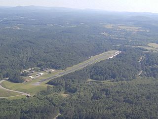
Northeast Alabama Regional Airport is five miles southwest of Gadsden, in Etowah County, Alabama. It is owned by Gadsden Airport Authority and it used to be Gadsden Municipal Airport. The FAA's National Plan of Integrated Airport Systems for 2009–2013 categorized as a general aviation facility.

Huntsville Executive Airport, also known as Tom Sharp Jr. Field and formerly Madison County Executive Airport, is a public-use airport in Madison County, Alabama, United States. It is owned by the Executive Flight Center and located eight nautical miles (14.80 km) northeast of the central business district of Huntsville. According to the FAA's National Plan of Integrated Airport Systems for 2009–2013, it is categorized as a general aviation facility.
Mesquite Metro Airport is a public use airport in Dallas County, Texas, 3 nautical miles (5.6 km) east of the central business district of Mesquite. The airport is west of the border of Dallas County and Kaufman County.
Warsaw Municipal Airport is a public use airport located two miles (3 km) north of the central business district of Warsaw, a city in Kosciusko County, Indiana, United States. It is owned by the Warsaw Board of Aviation Commissioners.
Fremont Municipal Airport is a city-owned public-use airport located three nautical miles (6 km) southwest of the central business district of Fremont, a city in Newaygo County, Michigan, United States. The airport is uncontrolled, and is used for general aviation purposes. Skydiving and ultralight activity are also conducted at the field. It is included in the Federal Aviation Administration (FAA) National Plan of Integrated Airport Systems for 2017–2021, in which it is categorized as a local general aviation facility.
Winchester Regional Airport is three miles southeast of Winchester, in Frederick County, Virginia. It was recognized by the state as a licensed commercial airport in 1937 and was Winchester Municipal Airport until 1987.
Scott Municipal Airport is a public-use airport located four nautical miles southwest of the central business district of Oneida, a city in Scott County, Tennessee, United States. The airport is owned by Scott County. Big South Fork Airpark, a gated community and residential airpark is located adjacent to the airport.
Medina Municipal Airport is a public use airport in Medina County, Ohio, United States. It is owned by the City of Medina and is located four nautical miles (7.41 km) east of the city's central business district. According to the FAA's National Plan of Integrated Airport Systems for 2007-2011, it is categorized as a reliever airport.

Sault Ste. Marie Municipal Airport, also known as Sanderson Field, is a city-owned, public-use airport located one nautical mile (1.85 km) southwest of the central business district of Sault Ste. Marie, a city in Chippewa County, Michigan, United States.
Highland County Airport is a public-owned, public-use airport located at 9500 North Shore Drive three nautical mile (4.8 km) southeast of the central business district of the city of Hillsboro, in Highland County, Ohio, United States.
Edgar County Airport is a public use airport in Edgar County, Illinois, United States. It is located five nautical miles north of the central business district of Paris, Illinois. The airport is included in the FAA's National Plan of Integrated Airport Systems for 2017–2021, which categorized it as a general aviation facility.
Rochelle Municipal Airport, also known as Koritz Field, is a city-owned public-use airport located two nautical miles south of the central business district of Rochelle, a city in Ogle County, Illinois, United States. It is included in the FAA's National Plan of Integrated Airport Systems for 2011–2015, which categorized it as a general aviation facility.
Crawford County Airport is a public use airport located four nautical miles east of the central business district of Robinson, a city in Crawford County, Illinois, United States. It is owned by the Crawford County Airport Authority and was formerly known as Robinson Municipal Airport. This airport is included in the National Plan of Integrated Airport Systems for 2011–2015, which categorized it as a general aviation facility.

