The Pennines, also known as the Pennine Chain or Pennine Hills, are a range of uplands mainly located in Northern England. Commonly described as the "backbone of England" because of its length and position, the range runs from Derbyshire and Staffordshire in the North Midlands to Northumberland in North East England, near the Anglo-Scottish border. The range starts near the valley of the River Trent to the south and extends northwards across the Peak District, South Pennines, Yorkshire Dales, and North Pennines, ending at the Tyne Gap. Beyond the gap are the Border Moors and Cheviot Hills, which are included in some definitions of the range.

The M62 is a 107-mile-long (172 km) west–east trans-Pennine motorway in Northern England, connecting Liverpool and Hull via Manchester, Bradford, Leeds and Wakefield; 7 miles (11 km) of the route is shared with the M60 orbital motorway around Manchester. The road is part of the unsigned Euroroutes E20 and E22.

The A62 road in Northern England runs between the cities of Leeds in West Yorkshire and Manchester in Greater Manchester covering a distance of 38.5 miles (62.0 km). It passes through Heckmondwike, Huddersfield, Failsworth and Oldham.

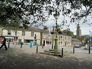
Milnrow is a town within the Metropolitan Borough of Rochdale, in Greater Manchester, England. It lies on the River Beal at the foothills of the South Pennines, and forms a continuous urban area with Rochdale. It is 2 miles (3.2 km) east of Rochdale town centre, 10 miles (16.1 km) north-northeast of Manchester, and spans from Windy Hill in the east to the Rochdale Canal in the west. Milnrow is adjacent to junction 21 of the M62 motorway, and includes the village of Newhey, and hamlets at Tunshill and Ogden.

Littleborough is a town in the Metropolitan Borough of Rochdale, Greater Manchester, England, in the upper Roch Valley by the foothills of the South Pennines, 3 miles (4.8 km) northeast of Rochdale and 13 miles (20.9 km) northeast of Manchester; Milnrow and the M62 motorway are to the south, and the rural uplands of Blackstone Edge to the east. According to the 2001 census, Littleborough, and its suburbs of Calderbrook, Shore and Smithy Bridge, had a population of 13,807.

The M602 motorway is a 4-mile (6.4 km) motorway, leading traffic into Salford, Greater Manchester, England, towards Manchester and by-passing the town of Eccles.

The A628 is a major road connecting Greater Manchester and South Yorkshire in northern England. It crosses the Pennine hills by way of Longdendale and the Woodhead Pass in the Peak District National Park. The road's altitude and exposure to bad weather create problems in winter and the road is sometimes closed due to snow or high winds.
Standedge is a moorland escarpment in the Pennine Hills of northern England between Marsden, West Yorkshire and Diggle, Greater Manchester. Standedge has been a major moorland crossing point since Roman times and possibly earlier.

The South Pennines is a region of moorland and hill country in northern England lying towards the southern end of the Pennines. In the west it includes the Rossendale Valley and the West Pennine Moors. It is bounded by the Greater Manchester conurbation in the west and the Bowland Fells and Yorkshire Dales to the north. To the east it is fringed by the towns of West Yorkshire whilst to the south it is bounded by the Peak District. The rural South Pennine Moors constitutes both a Site of Special Scientific Interest and Special Area of Conservation.

The geography of Greater Manchester is dominated by one of the United Kingdom's largest metropolitan areas, and in this capacity the landlocked metropolitan county constitutes one of the most urbanised and densely populated areas of the country. There is a mix of high density urban areas, suburbs, semi-rural and rural locations in Greater Manchester, but overwhelmingly the land use in the county is urban.

Scammonden Reservoir is a water reservoir in West Yorkshire, England. Its water surface area when full is 42 hectares (0.16 sq mi). The level of the bellmouth overflow above sea level is 252 metres (827 ft). The reservoir holds 78,000,000,000 litres (1.7×10¹⁰ imp gal; 2.1×10¹⁰ US gal). Its length is 1.4 kilometres (0.9 mi).

Butterworth Hall Brook is a water course in Greater Manchester, North-West England, which flows through the village of Milnrow and is a tributary of the River Beal.

Longden End Brook is a watercourse in Greater Manchester. It rises near Windy Hill, and flows down Rakewood Valley and underneath the M62 motorway at Rakewood Viaduct, before arriving at Hollingworth Lake, where it is the main feeder stream.

The Rakewood Viaduct carries the M62 motorway over Rakewood Valley and Longden End Brook between junctions 21 and 22 at Littleborough, Greater Manchester, England.

Piethorne Brook is a watercourse in Greater Manchester. It is a tributary of the River Beal.

Scammonden Bridge, also known locally as the Brown Cow Bridge, spans the Deanhead cutting carrying the B6114 Elland to Buckstones road over the M62 motorway in Kirklees, West Yorkshire, England. The bridge and Scammonden Reservoir to the west are named after Scammonden, the village that was flooded to accommodate the reservoir whose dam carries the motorway. On opening, the bridge was the longest concrete arch bridge in the UK.

Birch Services is a motorway service station located on the M62 motorway between Junction 18 (M60) and Junction 19 Heywood, close to Rochdale and Bury. There are two sides to the service station, the Eastbound services being quite old and the Westbound services being more modern. The services opened in 1972.

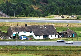
Stott Hall Farm is a farm located between the eastbound and westbound carriageways of the M62 motorway in Calderdale, England. It is the only farm in the UK situated in the middle of a motorway and was built in the 18th century on Moss Moor. It lies south of Booth Wood Reservoir where the carriageways are separated between junctions 22 and 23. The road divides for much of its length between the Windy Hill and Deanhead cuttings because of the surrounding geography but a myth persists that it was split because the Ken and Beth Wild refused to sell. However, the farm was actually owned by Yorkshire water at the time the M62 was built.


