
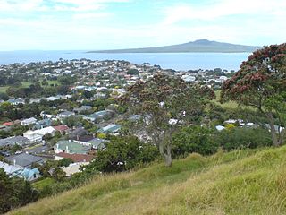
Devonport is a harbourside suburb of Auckland, New Zealand. It is located on the North Shore, at the southern end of the Devonport Peninsula that runs southeast from near Lake Pupuke in Takapuna, forming the northern side of the Waitematā Harbour. East of Devonport lies North Head, the northern promontory guarding the mouth of the harbour.
Grant Gillon is a former New Zealand politician. He was a member of parliament between 1996 and 2002, representing the Alliance Party, has held a number of seats in local government. He previously served on the Devonport-Takapuna Local Board representing Shore Action.

Northcote is a suburb of Auckland in northern New Zealand. It is situated on the North Shore, on the northern shores of Waitematā Harbour, four km northwest of Auckland CBD. The suburb includes the peninsula of Northcote Point and the northern approaches to the Auckland Harbour Bridge. Northcote Central is to the north of Northcote.

Takapuna is a suburb located on the North Shore of Auckland, New Zealand. The suburb is situated at the beginning of a south-east-facing peninsula forming the northern side of the Waitematā Harbour. While very small in terms of population, it was the seat of the North Shore City Council before amalgamation into Auckland Council in 2010 and contains substantial shopping and entertainment areas, acting as a CBD for the North Shore.

Glenfield is a suburb of Auckland, New Zelaand, located on the North Shore. Established as a rural community in the 1850s, the area developed as a suburban part of Auckland after the completion of the Auckland Harbour Bridge in 1959.

The Northern League is an amateur New Zealand association football competition. It is a top-tier competition during the winter season, and sits at step two overall.

Forrest Hill is a suburb located on the North Shore of Auckland, New Zealand.

Hillcrest is a suburb of the contiguous Auckland metropolitan area located in New Zealand. Since 2010, it has been under the jurisdiction of the Auckland Council, and is located in the North Shore, surrounded by Glenfield, Wairau Valley, Northcote and Birkenhead. The Auckland Northern Motorway passes to the east.

Bayswater is a suburb located on the North Shore of Auckland, New Zealand. It lies on a peninsula which juts into the Waitemata Harbour. Politically the suburb is part of the Devonport-Takapuna Local Board and the North Shore ward of Auckland Council.

Belmont is a suburb of Auckland, New Zealand. The name Belmont, which means "good view or hill", derives from a farm estate called "Belmont" which was subdivided in 1885. The suburb is in the North Shore ward, one of the thirteen administrative divisions of Auckland Council.
Vauxhall is a suburb of the North Shore of Auckland, New Zealand. Alison Park lies directly to the west, separating Vauxhall from Lake Road, which carries the majority of traffic between Takapuna and Devonport. Vauxhall is included in the Narrow Neck census area.

Takapuna Grammar School is a state coeducational secondary school located in the suburb of Belmont on the North Shore of Auckland, New Zealand. Established in 1927, the school mainly serves the eponymous suburb of Takapuna and the entire Devonport Peninsula. A total of 2008 students from Years 9 to 13 attend the school as of April 2023.
Castor Bay is a bay and suburb of the North Shore, located in Auckland which is in the North Island of New Zealand. Located between Milford and Campbells Bay, it is part of the East Coast Bays. To the east lies the islands of Rangitoto and Motutapu, which are easily visible from land. The suburb is in the North Shore ward, one of the thirteen administrative divisions of Auckland Council.
Campbells Bay is a suburb of the North Shore located in Auckland, New Zealand. Centennial Park is a popular recreational space that has walking tracks and stunning harbour views.

Wairau Valley is a suburb of Auckland, New Zealand. The area is predominantly light industrial/commercial. The Northern Motorway passes to the east, and the Wairau Park shopping complex extends to the north. The valley is drained by the Wairau Creek, which flows on through Milford and discharges into the Hauraki Gulf from an estuary at the northern end of Milford Beach.
The Northern Regional Football League Conference, currently known as Lotto Sport Italia NRFL Conference for sponsorship reasons, is a New Zealand Semi-Professional football league. The league is run by the Auckland Football Federation and includes football clubs located in the northern part of the North Island, New Zealand. It is open to clubs from the Northland, Auckland, Waikato and Bay of Plenty provinces. Up until 2022, the competition was known as NRFL Division 2, and was not split into Northern and Southern competitions.
Glenfield Rugby Union and Sports Club Inc. is a sports club based in Glenfield, a suburb of Auckland, New Zealand.
The North Harbour Rugby Union club rugby title has been contested since the formation of the North Harbour Rugby Union in New Zealand in 1985. The current trophy awarded to the winner is the ASB Bank Cup. The Premier Grade championship cup has also been named the New Zealand Couriers Cup The current champions are North Shore RFC. The Reserve Grade Championship Cup is named the "Stuart Cup" after North Shore Rugby Club stalwart Jim Stuart who donated the Cup to the North Harbour Rugby Union in 1985. From 1985 to 1996 Harbour club finals were contested at Onewa Domain. Since 1997 all Club finals have been held at North Harbour Stadium. Club finals are usually held in July.

The Waitemata County was one of the counties of New Zealand in the North Island. Established in 1876, the county covered West Auckland, Rodney and the North Shore. The county shrunk in size between 1886 and 1954 when various urban areas on the North Shore and in West Auckland became boroughs and established their own local councils. The Waitemata County was dissolved in 1974, with the county council area being taken over by the newly established Waitemata City in the west, and by Takapuna City and Rodney Council in the north.

Oruamo or Hellyers Creek is a stream and tidal estuary of Upper Waitematā Harbour in the Auckland Region of New Zealand's North Island. It flows through the western North Shore.

