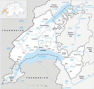
Vaud, more formally the canton of Vaud, is one of the 26 cantons forming the Swiss Confederation. It is composed of ten districts and its capital city is Lausanne. Its flag bears the motto "Liberté et patrie" on a white-green background.

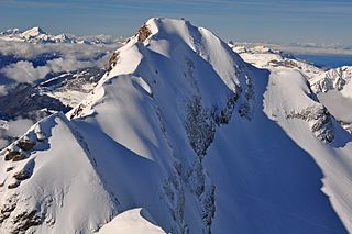
The Diablerets are a huge ice-covered mountain massif of the Alps, culminating at the Sommet des Diablerets at 3,210 metres (10,530 ft) above sea level and straddling the border between the Swiss cantons of Vaud (VD) and Valais (VS). The northeastern part of the massif stretches also into the canton of Bern (BE).

Romandy is the French-speaking part of western Switzerland. In 2018, about 2.1 million people, or 25.1% of the Swiss population, lived in Romandy. The majority of the romand population lives in the western part of the country, especially the Arc Lémanique region along Lake Geneva, connecting Geneva, Vaud and the Lower Valais.
The Swiss Confederation comprises the 26 cantons of Switzerland.

Léman was the name of a canton of the Helvetic Republic from 1798 to 1803, corresponding to the territory of modern Vaud. A former subject territory of Bern, Vaud had been independent for only four months in 1798 as the Lemanic Republic before it was incorporated into the centralist Helvetic Republic. Léman comprised all of the territory of Vaud detached from Bernese occupation, apart from the Avenches and the Payerne which, after 16 October 1802, were annexed by the canton of Fribourg until the Napoleonic Act of Mediation the following year when they were restored to the newly established and newly sovereign canton of Vaud.

Jacques of Savoy was Count of Romont and Lord of Vaud.
The Grand Muveran is a mountain of the Bernese Alps, located on the border between the cantons of Vaud and Valais. At 3,051 metres, it is the highest summit of the group lying between the Rhone knee and the Pas de Cheville and the westernmost three-thousander of the Bernese Alps. The closest localities are Les Plans-sur-Bex and Ovronnaz (Valais). It is accompanied by the smaller peak of Petit Muveran.

The Oldenhorn is a mountain in the western Bernese Alps in Switzerland. The summit is the tripoint between the cantons of Vaud, Berne and Valais.

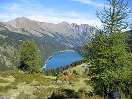
The Scex Rouge is a mountain of the Alps, overlooking Les Diablerets in the canton of Vaud. Along with the Oldenhorn to the east, it is one of the main peaks of the Diablerets, a huge ice-covered mountain near the western end of the Bernese Alps, straddling the border between the cantons of Vaud, Valais, and Bern, and exceeding 3,000 metres (9,800 ft) above sea level. On its west side, the Scex Rouge is part of a nearly 2,000-metre-high (6,600 ft) amphitheatre of cliffs surrounding the Creux de Champ valley, south of Les Diablerets. On its southeast side, the Scex Rouge overlooks the Tsanfleuron Glacier, the largest in the massif. Administratively, the mountain is part of the municipality of Ormont-Dessus, which also includes Les Diablerets.
The Arnenhorn is a mountain of the Bernese Alps, located on the border between the Swiss cantons of Vaud and Bern. It overlooks the Arnensee on its eastern side.
Le Tarent is a mountain in the western Bernese Alps, overlooking Les Diablerets in the canton of Vaud. At 2,548 metres above sea level, it is the highest mountain of the range lying north of the Col du Pillon. The mountain, which lies near the border with the canton of Bern, is composed of several subsidiary summits, the highest being the Châtillon and La Para.

Mont Tendre is a mountain of the Jura, located between the valley of Joux and the basin of Lake Geneva in the canton of Vaud. With an elevation of 1,679 metres above sea level, it is the highest summit of the Swiss portion of the Jura Mountains and, therefore, the highest summit of Switzerland outside the Alps. It is also the most isolated mountain of the canton. It is found in the community of Montricher.

Lausanne railway station Is the main intercity and regional railway station for the city of Lausanne, Vaud, Switzerland. It is often known as Lausanne CFF to distinguish it from others in the town.

The Barony of Vaud was an appanage of the County of Savoy, corresponding roughly to the modern Canton of Vaud in Switzerland. It was created by a process of acquisition on the part of a younger brother of the reigning count beginning in 1234 and culminated in the formalisation of its relationship to the county in 1286. It was semi-independent state, capable of entering into relations with its sovereign, the Holy Roman Emperor, and of fighting alongside the French in the Hundred Years' War. It ceased to exist when it was bought by the count in 1359. It was then integrated into the Savoyard state, where the title Baron of Vaud remained a subsidiary title of the heads of the family at least as late as the reign of Charles Albert of Sardinia, although the territory of the barony was annexed by the Canton of Bern during the Protestant Reformation (1536).
The Col de Jable is a mountain pass in the western Swiss Alps, connecting L'Etivaz in the canton of Vaud to Gstaad in the canton of Bern. The pass is located between the Gummfluh and the Wittenberghorn. It is traversed by a trail.
The Tête aux Chamois is a summit of the Diablerets massif, overlooking the Col du Pillon in the canton of Vaud. It is accessible by aerial tramway from the Col du Pillon and from Reusch via Oldenegg. From the summit of the Tête aux Chamois another aerial tramway leads to the summit of the Scex Rouge and the nearby Tsanfleuron Glacier.
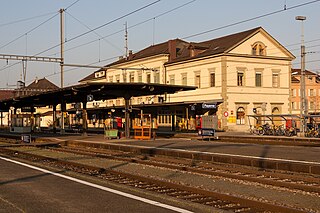
Payerne railway station is a railway station in the municipality of Payerne, in the Swiss canton of Vaud. It is located at the junction of the standard gauge Fribourg–Yverdon and Palézieux–Lyss lines of Swiss Federal Railways.

The S4 is a railway service of RER Vaud that provides hourly service between Allaman and Palézieux in the Swiss canton of Vaud. On weekdays, rush-hour services continue from Palézieux to Romont, in Fribourg. Swiss Federal Railways, the national railway company of Switzerland, operates the service.
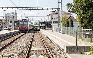
The S9 is a railway service of RER Vaud that provides hourly service between Lausanne and Kerzers in the Swiss cantons of Vaud and Fribourg, respectively. Swiss Federal Railways, the national railway company of Switzerland, operates the service.