Woodmancote, Tewkesbury Borough

Last updated

Woodmancote
Cloudy Bishops Cleeve from Cleeve Hill - geograph.org.uk - 361957.jpg
Bishops Cleeve and Woodmancote from Cleeve Hill
Gloucestershire UK location map.svg
Red pog.svg
Woodmancote
Location within Gloucestershire
Population3,029 (2011 Census)
OS grid reference SO971272
Civil parish
  • Woodmancote
District
Shire county
Region
Country England
Sovereign state United Kingdom
Post town Cheltenham
Postcode district GL52
Dialling code 01242
Police Gloucestershire
Fire Gloucestershire
Ambulance South Western
List of places
UK
England
Gloucestershire
51°56′37″N2°02′34″W / 51.943607°N 2.042739°W / 51.943607; -2.042739 Coordinates: 51°56′37″N2°02′34″W / 51.943607°N 2.042739°W / 51.943607; -2.042739

Woodmancote is a village and civil parish in Gloucestershire, England. The parish lies immediately east of Bishop's Cleeve; the village is about 3+12 miles (6 km) north of Cheltenham. In old English the name meant 'woodmen's cottage' and an early form was Wudumannacote. In the southeast of the parish is the small village of Cleeve Hill, under the slopes of the hill of the same name.

Contents

There is also an area called Woodmancote in Dursley, also in Gloucestershire.

History

Woodmancote in 1828.PNG

Woodmancote.PNG

The maps above highlight the fact that no significant development occurred between 1828 and 1945, only infrastructure such as new roads and a railway line seem to be new features. The physical lack of development is also shown in its neighbouring village Bishop's Cleeve. It does show a large amount of arable land as fields in both maps. This would suggest that the people who lived there were mostly working in agriculture for many generations.

The Domesday Book (1086) does not include Woodmancote. It became a place in its own right when estates in the area were organised by the Bishop's officers around 1170. [1] Over centuries Woodmancote remained an area of smallholdings and arable fields. [2] Only in 1847 the traditional farming of the villagers on medieval open-fields ended, as arable land became enclosed into the fields we see today. [3] For 600 years Bishop's Cleeve and Woodmancote have been hard to define as two separate parishes. This was because both were "in the same manor of the Bishop of Worcester and so it is often impossible to distinguish in his records". [3] The Black Death saw one third of the population of Bishop's Cleeve and Woodmancote die. [3]

Haymes is a hamlet within Woodmancote at the top of Cleve Hill: Haymes House is a Grade II listed Georgian mansion.

In the 1870s, Woodmancote was described by John Marius Wilson's Imperial Gazetteer of England and Wales as:

"a hamlet in Bishops-Cleeve parish, Gloucester; 3½ miles W by S of Winchcomb. Real property, £2,459; of which £40 are in quarries. Pop., 431. Houses, 100.". [4]

The village is the home of the Woodmancote Evangelical Free Church, part of the Countess of Huntingdon's Connexion. [5]

Boundaries

Boundary of Woodmancote.png

The map above shows the change in boundaries of the Woodmancote civil parish over time, with the newer boundary line adjacent to the railway line and the old boundary covering roughly half of what today is part of Bishop's Cleeve.

The boundaries of Woodmancote changed in 1883 and 1953. It gained 120 acres from the Bushcombe Island that was part of Bishop’s Cleeve. It gained again another 46 acres in April 1953 but lost 143 acres south of Station Road to Bishop’s Cleeve. The railway line is still part of Woodmancote. Since 1953, the village comprises 886 acres. [2]

Infrastructure and development

In 1886 a medical examiner of Woodmancote reported very serious sanitary problems. Nearly all of the drinking water sources such as wells and ditches were condemned. Woodmancote was connected to mains water four years later in 1891. The first telephone exchange in Woodmancote was opened by the National Telephone Company in 1899. The local hotel named the Rising Sun was the first to receive a number which was 502.

The Cheltenham District Gas Company supplied gas to Woodmancote from around 1925. Electricity was not supplied until after World War II, however Cleeve Hill had mains installed underground in the 1930s. [2]

Woodmancote's development has been stunted because of where it is located: its position at the foot of Cleeve Hill gives the settlement only a westerly direction to expand, but only to an extent before it reaches the boundary of Bishop's Cleeve.

Transport

The main road running through Woodmancote is called Station Road as it led to Bishop's Cleeve railway station. This road leads straight into Bishop's Cleeve to the west and Cheltenham to the south. From there, the M5 is easily accessible.

Woodmancote and Bishop's Cleeve were once served by a railway line that divides the two parishes. It was created on 1 June 1906 by the Great Western Railway which ran from Stratford-upon-Avon and finished at Cheltenham. The railway station closed on 7 March 1960 and was demolished. An accident occurred later on the railway line which led to its dismantlement by 1980. A 12-mile stretch of the track has been reconstructed through Woodmancote which has been reopened and is now preserved as heritage of the Gloucestershire Warwickshire Railway. [2]

In November 2022, the only bus service in the village was withdrawn. [6]

Education

In the 1841 census, the first schoolteacher was recorded for Woodmancote, George Sheppard at the age of 25. In the 1851 census, three women schoolmistresses were recorded but in the 1861 census none remained in the village. It wasn't until 1906 to 1910 that a school was started by Miss Waghorne. A larger, six-classroom primary school was built by the County Council in 1972 on Station Road. [2]

Population

Woodmancote population time series (1871-2011).png

This graph shows the total population at 10 year intervals recorded by the Census in the United Kingdom since 1871 (no census data from 1941 as the National census did not occur then).

As from 2011, Woodmancote had a population of 3,029 according to the 2011 census. [7] The graph shows an initial decrease in total population from the years 1871-1891 to 312, however from that point the population gradually increased to the year 1961 with 1,146 inhabitants. From that point the increase accelerated with a sudden drop from 2,922 in 1991 to 2,630 in 2001.

Woodmancotes Demographics is typical of a rural village as it has an increasingly aging population.

People per house in Woodmancote, Tewkesbury (1881-2011).png

This graph shows the average number of people per house in Woodmancote. From 1881 to 1901 there are about 3 people per house, however this increases to almost 4.5 people per house in 1920. From this point it decreases to the current level of 2.5 people per house. As the population graph shows an increase in population during this time, this would mean that there has been an increase in the construction of new houses.

Employment

Occupations of Woodmancote 1881.png Occupations of Woodmancote 2011.png

These charts show the types of jobs that occurred in 1881 and 2011 and the number of people who had them as professions. The charts indicate that within the 130 years of these censuses, occupations have developed from the primary sector such as agriculture to the service sector such as administration.

Related Research Articles

<span class="mw-page-title-main">Cotswolds</span> Protected area in south central England

The Cotswolds is a region in central-southwest England, along a range of rolling hills that rise from the meadows of the upper Thames to an escarpment above the Severn Valley and Evesham Vale.

<span class="mw-page-title-main">Gloucestershire</span> County of England

Gloucestershire is a county in South West England. The county comprises part of the Cotswold Hills, part of the flat fertile valley of the River Severn and the entire Forest of Dean.

<span class="mw-page-title-main">Cheltenham</span> Place in England

Cheltenham, also known as Cheltenham Spa, is a spa town and borough on the edge of the Cotswolds in the county of Gloucestershire, England. Cheltenham became known as a health and holiday spa town resort, following the discovery of mineral springs in 1716, and claims to be the most complete Regency town in Britain.

<span class="mw-page-title-main">Bishop's Cleeve</span> Human settlement in England

Bishop's Cleeve is a major village in the Borough of Tewkesbury, Gloucestershire, north of Cheltenham. The village lies at the foot of Cleeve Hill, the highest point in the Cotswolds, and borders Woodmancote on the east side of the Gloucestershire Warwickshire railway line that splits the two parishes. Bishop's Cleeve had a population of 10,612 in 2011, and was put at 14,068 at the 2021 Census. The village saw rapid growth during the 20th century as a result of the construction of Smiths Aerospace factory near the village after the Second World War. Currently, population and residential growth is a contentious subject due to the vast expansion of the housing estates without increased amenities. At the moment, a bid for 500 more houses has been refused but is currently under appeal.

<span class="mw-page-title-main">Churchdown</span> Human settlement in England

Churchdown is a large village in Gloucestershire, England, situated between Gloucester and Cheltenham in the south of the Tewkesbury Borough.

<span class="mw-page-title-main">Southam, Gloucestershire</span> Human settlement in England

Southam is a village in Gloucestershire, England, located on the outskirts of Cheltenham. Its main features are a castle, which has now been converted to a hotel, and the Gloucestershire Warwickshire Railway, which runs through the outskirts of the village.

<span class="mw-page-title-main">Stoke Orchard</span> Human settlement in England

Stoke Orchard is a village or hamlet north-west of Cheltenham in Gloucestershire, England.

<span class="mw-page-title-main">Charlton Kings</span> Human settlement in England

Charlton Kings is a contiguous village adjoining Cheltenham in Gloucestershire, England. The area constitutes a civil parish of 10,396 residents (2011).

<span class="mw-page-title-main">Hill, Gloucestershire</span> Human settlement in England

Hill is a village and civil parish in South Gloucestershire, England, midway between the towns of Thornbury in South Gloucestershire and Berkeley in Gloucestershire. The parish stretches from the banks of the River Severn to an outcrop of the Cotswolds escarpment. At the 2001 census, it had a population of 114. Hill is approximately 5 miles from the M5 motorway which links to Gloucester, Cheltenham and Bristol.

<span class="mw-page-title-main">Aston Ingham</span> Village in Herefordshire, England

Aston Ingham is a village in south-eastern Herefordshire, England, near Newent and about 7 miles (11 km) east of Ross-on-Wye. The population of the village at the 2011 census was 398. There is a church, dedicated to St John the Baptist, which has been a Grade II* listed building since 17 March 1987.

<span class="mw-page-title-main">Ashchurch</span> Human settlement in England

Ashchurch is a village in the Borough of Tewkesbury in the ceremonial county of Gloucestershire, England, 2 miles (3.2 km) east of the town of Tewkesbury, 11 miles (18 km) southwest of Evesham, 10 miles (16 km) north of Cheltenham, 13 miles (21 km) north-north east of Gloucester and 10 miles (16 km) south of Pershore.

<span class="mw-page-title-main">Leckhampton</span> District in south Cheltenham, Gloucestershire, England

Leckhampton is a Gloucestershire village and a district in south Cheltenham, Gloucestershire, England. The area is in the civil parish of Leckhampton with Warden Hill and is part of the district of Cheltenham. The population of the civil parish taken at the 2011 census was 4,409.

<span class="mw-page-title-main">Suckley</span> Human settlement in England

Suckley is a village and civil parish in the Malvern Hills District in the county of Worcestershire, England, close to the border with Herefordshire. The parish includes the hamlets of Suckley Knowl, Suckley Green at SO719532 and Longley Green at SO733503.

<span class="mw-page-title-main">Gotherington</span> Human settlement in England

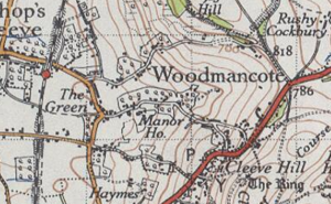
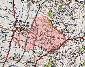
Gotherington is a small village north of Bishops Cleeve in Gloucestershire, England. It is surrounded on the north by the villages of Woolstone and Oxenton, and to the south by Woodmancote and Bishop's Cleeve, a very large urban village. Gotherington has a population of around 1,200, while its neighbour, Bishops Cleeve, has a population of 15,000. The populations reduced at the 2011 census to 995 for Gotherington.

<span class="mw-page-title-main">Woodmancote, Horsham District</span> Human settlement in England

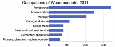
Woodmancote is a village and civil parish in the Horsham District of West Sussex, England. The village is 1 mile (1.5 km) southeast of Henfield on the A281 road. It should not be confused with the other West Sussex village of Woodmancote near Chichester.

<span class="mw-page-title-main">Old Cleeve</span> Human settlement in England

Old Cleeve is a village 5 miles (8 km) south east of Minehead in the Somerset West and Taunton district of Somerset, England, and also a civil parish. The civil parish of Old Cleeve covers an area of 2,092 hectares and includes the villages of Old Cleeve, Blue Anchor, Roadwater and Washford as well as hamlets such as Bilbrook, Chapel Cleeve, Golsoncott and Leighland Chapel. Approximately half the parish lies within the Exmoor National Park. The remaining half is on the southern edge of Exmoor. The village has been in existence since the early 13th century. The village held its first council meeting in 1711. By the 1720s the village had several churches, in which to meet. The town hall was built in 1727. The first church here was built in 1694, built by the Eastern Christian Society. This church was destroyed in a fire in 1847, and has been rebuilt and restored. In 2011, the population of the parish was 1,672.

Winchcombe was, from 1894 to 1935, a rural district in the Cotswolds area of England. It included parts of two administrative counties: Gloucestershire and Worcestershire.

<span class="mw-page-title-main">Bishops Cleeve railway station</span> Disused railway station in Tewkesbury, England

Bishop's Cleeve railway station was a railway station that served the village of Bishop's Cleeve in Gloucestershire, England.

<span class="mw-page-title-main">St Michael & All Angels Church, Bishop's Cleeve</span> Church in Gloucestershire, United Kingdom

St Michael & All Angels is the Anglican church in the village of Bishop's Cleeve, just north of Cheltenham in Gloucestershire. Informally the church is known simply as St Michael's.

References

  1. Woodmancote Parish council. "Woodmancote online Gloucestershire". Woodmancote online Gloucestershire. Retrieved 27 April 2015.
  2. 1 2 3 4 5 Woodmancote Parish council. "Woodmancote village appraisal 2006/2007" (PDF). Woodmancote online Gloucestershire. Retrieved 27 April 2015.
  3. 1 2 3 Aldred, David .H (18 October 2013). A History Of Bishop's Cleeve And Woodmancote. Amberley Publishing Limited. p. 77. ISBN   9781445624655 . Retrieved 27 April 2015.
  4. Wilson, John Marius (1870). Gazetteer of England and Wales. Edinburgh: A. Fullerton & Co. Retrieved 27 January 2015.
  5. Woodmancote church. "Woodmancote church". Woodmancote church. Retrieved 27 April 2015.
  6. Cameron, Cllr Caz. "Bus Service for Woodmancote – We Want to Hear Your Ideas! – Woodmancote Parish Council" . Retrieved 3 December 2022.
  7. "<Woodmancote> (Parish): Key Figures for 2011 Census: Key Statistics". Neighbourhood Statistics. Office for National Statistics. Retrieved 27 January 2015.