
Multnomah Falls is a waterfall located on Multnomah Creek in the Columbia River Gorge, east of Troutdale, between Corbett and Dodson, Oregon, United States. The waterfall is accessible from the Historic Columbia River Highway and Interstate 84. Spanning two tiers on basalt cliffs, it is the tallest waterfall in the state of Oregon at 620 ft (189 m) in height. The Multnomah Creek Bridge, built in 1914, crosses below the falls, and is listed on the National Register of Historic Places.
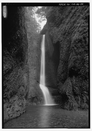
Oneonta Gorge is a scenic gorge located in the Columbia River Gorge area of the American state of Oregon. The U.S. Forest Service has designated it as a botanical area because of the unique aquatic and woodland plants that grow there. Exposed walls of 25-million-year-old basalt are home to a wide variety of ferns, mosses, hepatics, and lichens, many of which grow only in the Columbia River Gorge. Oneonta Gorge with its 50 species of wildflowers, flowering shrubs and trees has been described as "one of the true dramatic chasms in the state." The Oneonta Gorge Creek Bridge is listed on the National Register of Historic Places.

Silver Falls State Park is a state park in the U.S. state of Oregon, located near Silverton, about 20 miles (32 km) east-southeast of Salem. It is the largest state park in Oregon with an area of more than 9,000 acres (36 km2), and it includes more than 24 miles (39 km) of walking trails, 14 miles (23 km) of horse trails, and a 4-mile (6.4 km) bike path. Its 8.7-mile (14.0 km) Canyon Trail/Trail of Ten Falls runs along the banks of Silver Creek and by ten waterfalls, from which the park received its name. Four of the ten falls have an amphitheater-like surrounding that allows the trail to pass behind the flow of the falls. The Silver Falls State Park Concession Building Area and the Silver Creek Youth Camp-Silver Falls State Park are separately listed on the U.S. National Register of Historic Places.

Wahclella Falls is a waterfall along Tanner Creek, a tributary of the Columbia River, Multnomah County, Oregon, United States. It enters the river within the Columbia River Gorge.

Mill Creek Falls, is a waterfall located in the Rogue River Canyon within the Prospect State Scenic Viewpoint in Jackson County, in the U.S. state of Oregon. The waterfall is located at the south end of Mill Creek as it plunges into the Rogue River over a carved cliff surrounded by walls of petrified volcanic ash consequence of Mount Mazama eruption.
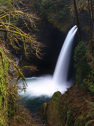
Metlako Falls is a waterfall on Eagle Creek in the Columbia River Gorge National Scenic Area in Hood River County, Oregon, United States. It is the furthest downstream of the major waterfalls on Eagle Creek. Like upstream Punch Bowl Falls, Metlako is also in the form of a punchbowl. The falls is 31 meters (101 ft) tall, though people have measured it anywhere from 30 to 46 m tall. It is the upstream limit for salmon spawning in Eagle Creek.
Camp Benson Falls is a 90-foot waterfall on Summit Creek in Lindsey Creek State Park, Hood River County, Oregon, United States. Its elevation is 369 feet (112 m).

Fairy Falls is a 20-foot waterfall on the Oregon side of the Columbia River Gorge in the United States. As part of a tributary of Wahkeena Creek, Fairy Falls is located upstream from the much larger Wahkeena Falls. While small, this fan-shaped waterfall is a destination for photographers, mainly because of the scenic view. The creek cascades through a mossy rock slide lined with ferns, until rocky ledges of basalt break the water into various lacy streams.
There are four prominent waterfalls in the basin of a short tributary of Sulphide Creek, on the southeast flank of 9,127-foot (2,781m) Mount Shuksan in North Cascades National Park, Washington. Seahpo Peak Falls and Cloudcap Falls, the taller two of the three, are located on separate streams that converge and plunge over Rockflow Canyon Falls. The unnamed outlet stream from these waterfalls flows into Sulphide Creek, which flows into the Baker River. Another waterfall is Jagged Ridge Falls, on a tributary of the unnamed stream.

Twister Falls is a prominent waterfall that is formed as Eagle Creek cascades 140 feet (43 m) into a narrow canyon and forms two streams that appear to "twist" around each other, hence the name "twister". The falls begin with a small sliding cascade that drops 5 feet (1.5 m) over a rocky slope into a pool, followed by some rapids. The next tier is the twisting tier, which plunges 50 feet (15 m). Before this point, a small portion of the stream splits off and makes a sheer plunge of approximately equal height down the canyon. Then, the waters combine and form a final drop of 80 feet (24 m).

Eagle Creek is a tributary of the Columbia River in Multnomah and Hood River counties in the U.S. state of Oregon. It cuts through a narrow canyon in its 3,200 feet (980 m) descent to the Columbia River Gorge and is known for its concentration of 13 waterfalls in about 5 miles (8.0 km) distance. Eight major falls are on Eagle Creek and the East Fork Eagle Creek itself, while five are on its tributaries.
The Paradise River in Washington state, United States, is known for having a total of eight major waterfalls.

Salt Creek Falls is a cascade and plunge waterfall on Salt Creek, a tributary of the Middle Fork Willamette River, that plunges into a gaping canyon in the Willamette National Forest near Willamette Pass in Lane County, Oregon. The waterfall is notable for its main drop of 286 feet (87 m), ranking third highest among plunge waterfalls in Oregon, after Multnomah Falls and Watson Falls.) The pool at the bottom of Salt Creek Falls waterfall is 66 feet (20 m) deep.

Big Butte Creek is a 12-mile-long (19 km) tributary of the Rogue River in the U.S. state of Oregon. It drains approximately 245 square miles (635 km2) of Jackson County. Its two forks, the North Fork and the South Fork, both begin high in the Cascade Range near Mount McLoughlin. Flowing predominantly west, they meet near the city of Butte Falls. The main stem flows generally northwest until it empties into the Rogue Falls was incorporated in 1911, and remains the only incorporated town within the watershed's boundaries.

The South Fork Clackamas River is a tributary, roughly 8 miles (13 km) long, of the Clackamas River in the U.S. state of Oregon. Beginning near South Fork Mountain in the western Cascade Range, the river flows generally north through Clackamas County to meet the larger river at Big Cliff. Most of the South Fork's drainage basin lies within the Mount Hood National Forest.
Wallalute Falls is a large waterfall located on Compass Creek on the north slopes of Mount Hood in the Hood River County, Oregon, at an elevation of 4,879 feet (1,487 m). For many years maps have mislabeled the location of Wallalute Falls locating it on the Eliot Branch of the West Fork Hood River, one canyon over from Compass Creek where it is still labeled on maps today. Historical documentation in Jack Grauer's book A Complete History of Mt Hood, however, provides 1890s-era photos of two waterfalls located in this area, one labeled Wallalute and one labeled "Strawnahans", where only "Strawnahans" Falls is a photographic match to the actual waterfall located on the Eliot Branch visible from the Cloud Cap road at Inspiration Point.

Salt Creek is a 30-mile (48 km) tributary of the Middle Fork Willamette River in Lane County in the U.S. state of Oregon. It is named for salt springs along its banks that are used as licks by deer. The stream originates as an outflow of Lower Betty Lake in the forested Cascade Range just southeast of Waldo Lake. It proceeds generally south, through Gold Lake, to Route 58, which it then follows mainly northwest for about 26 miles (42 km) to its mouth at the Middle Fork Willamette River just below Hills Creek Dam. At Salt Creek Falls—roughly 4 miles (6.4 km) west of Willamette Pass and a little more than 22 miles (35 km) upstream from the mouth—the stream plunges 286 feet (87 m), discharging an average of 50,000 U.S. gallons (190,000 L) of water per minute, or 111 cubic feet per second (3.1 m3/s). Below the falls, the creek enters a narrow canyon shaped by glaciation and basaltic lava flows from higher in the Cascades. McCredie Hot Springs, at the former community of McCredie Springs, are natural hot springs along the lower half of Salt Creek beside Route 58.

Winter Falls, is a waterfall located in the Silver Falls State Park at the east end of the city of Salem, in Marion County, in the U.S. state of Oregon. It is located in a privileged area on the west foothills where Mount Hood National Forest meets with the Middle Santiam Wilderness. Several prominent waterfalls are located in the Park along Trail of Ten Falls: South Falls, Lower South Falls, Lower North Falls, and Drake Falls—among others.

North Falls is a waterfall located in the Silver Falls State Park at the east end of the city of Salem, in Marion County, in the U.S. state of Oregon. It is located in a privileged area on the west foothills where Mount Hood National Forest meets with the Middle Santiam Wilderness. Several prominent waterfalls are located in the Park along Trail of Ten Falls: South Falls, Drake Falls, Lower South Falls, and Winter Falls—among others.

Twin Falls is a waterfall located in the Silver Falls State Park at the east end of the city of Salem, in Marion County, in the U.S. state of Oregon. It is located in the west foothills where Mount Hood National Forest meets with the Middle Santiam Wilderness. Several prominent waterfalls are located in the Park along Trail of Ten Falls: South Falls, Drake Falls, Lower South Falls, and Winter Falls—among others.
