
Elidir Fawr is a mountain in Snowdonia, north Wales, the northernmost peak in the Glyderau. Its name means 'Big Elidir', named after a legendary warrior king of the 6th century also known as Eliffer Gosgorddfawr.

Moel Hebog is a mountain in Snowdonia, north Wales which dominates the view west from the village of Beddgelert. It gives name to a whole range of peaks in the north-western corner of Snowdonia, which include the Nantlle Ridge and Mynydd Mawr.

The Snowdon Massif, Snowdon Range or Yr Wyddfa massif is one of the three mountain groups in Snowdonia, north Wales, to include mountains over 3,000 feet (914 m) high. It occupies the area between Beddgelert, Pen-y-Pass and Llanberis. It is surrounded by the Glyderau to the north-east, Moel Siabod to the east, the Moelwynion to the south, Moel Hebog, the Nantlle Ridge and Mynydd Mawr to the west, and by flatter land leading down to Caernarfon and the Menai Strait to the north-west.

Moel Eilio is a mountain in Snowdonia, North Wales, that is situated approximately 3 miles north-west of Snowdon itself. It has two subsidiary tops, Foel Gron and Foel Goch (Eilio). The average annual temperature of the mountain is around 6 °C (43 °F). During the winter season, some significant accumulations of snowfall is known to take place on Moel Eilio, due to its relatively flat, grassy slopes.

Manod Mawr is a mountain in North Wales and forms part of the Moelwynion. Although known as a mountain in the eastern Moelwyns, it and its sister peaks are sometimes known as the Ffestiniog hills.

The Moelwynion are a group of mountains in central Snowdonia, north Wales. They extend from the north-east of Porthmadog to Moel Siabod, the highest of the group. The name derives from the names of two of the largest mountains in the group, Moelwyn Mawr and Moelwyn Bach, 770m and 710m, respectively. Moel Siabod, to the north, is the highest at 872m.

Moel Penamnen is a mountain just north of Blaenau Ffestiniog, North Wales and forms part of the Moelwynion.

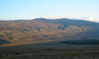
Mynydd Mawr is a mountain in Snowdonia, North Wales, approximately 7 km (4.3 mi) west of Snowdon itself, overlooking Llyn Cwellyn and being the northern outlier of the Moel Hebog group. A popular ascent starts from Rhyd Ddu. On its western flank are the remains of ancient settlements and field systems. The profile of Mynydd Mawr from the north is often thought to resemble an elephant lying down, and consequently the mountain is often colloquially also called "Yr Eliffant", or "Elephant Mountain" by non-Welsh speakers.

Manod Mawr North Top is a mountain in North Wales and forms part of the Moelwynion.

Carnedd y Filiast is a mountain near Cerrigydrudion on the border of the Snowdonia National Park, North Wales and is 669 metres (2,195 ft) high.

Mynydd Graig Goch is the western end peak of the Nantlle Ridge, and is a subsidiary summit of Craig Cwm Silyn. It is also the most westerly 2000 ft peak in Wales. For many years it was excluded from lists of the Welsh 2000 ft mountains because of a spot height of 609 metres (1998') on OS maps. However, this changed in 2008; after years of speculation a group of hillwalkers carried out a precise GPS survey of the peak, measuring the absolute height as 609.75 metres.

Arenig Fach is a mountain in southern Snowdonia, north Wales. It is a peak in the Arenig range and lies to the north of its parent peak Arenig Fawr.

Moel Llyfnant is a mountain in the southern portion of the Snowdonia National Park in Gwynedd, Wales. It is a peak in the Arenig mountain range. It lies to the west of Arenig Fawr. It has one notable top, the twin peaked Gallt y Daren, being at the end of its west ridge.
Gallt y Daren is a peak in the southern half of the Snowdonia National Park in Gwynedd, North Wales, and forms part of the Arenig mountain range. It is a top of Moel Llyfnant, and is twin peaked. It lies to the west of Moel Llyfnant.
Foel Boeth is the twin top of Gallt y Daren in the southern half of the Snowdonia National Park in Gwynedd, North Wales, and forms part of the Arenig mountain range. Its parent peak is Moel Llyfnant.

Y Ro Wen is a mountain just north of Blaenau Ffestiniog, North Wales and forms part of the Moelwynion.

Moel Emoel is a hill within the Snowdonia National Park in Gwynedd, North Wales.

Cadair Ifan Goch is a crag located above the Conwy Valley in North Wales in the community of Llanddoged and Maenan, and owned by the National Trust. The views extend across the whole of the valley to the Carneddau mountains, and even as far south as the Arenig mountains. The summit of the hill, a bit further up from the crag, reaches 207 metres (679 ft) above sea level.
