Yakushima, Kagoshima

Last updated • 1 min readFrom Wikipedia, The Free Encyclopedia
Yakushima
屋久島町
Town
Miyanoura (32273795996).jpg
View of Miyanoura and Yaku wetland area
Flag of Yakushima, Kagoshima.svg
Emblem of Yakushima, Kagoshima.svg
Yakushima in Kagoshima Prefecture Ja.svg
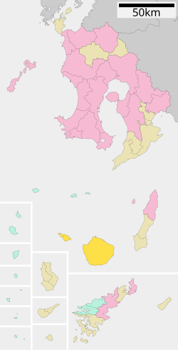
Location of Yakushima in Kagoshima Prefecture
Japan location map with side map of the Ryukyu Islands.svg
Red pog.svg
Yakushima
Location in Japan
Coordinates: 30°23′24″N130°39′4″E / 30.39000°N 130.65111°E / 30.39000; 130.65111
CountryJapan
Region Kyushu (Ōsumi)
Prefecture Kagoshima Prefecture
District Kumage
First official recorded607 AD
Kami-yaku town settledApril 1, 1958
Yaku town settledApril 1, 1959
Merged with two towns and current town name changedOctober 1, 2007
Government
  Mayor Tonao Hidaka
Area
  Total540.98 km2 (208.87 sq mi)
Population
 (January 2008)
  Total13,486
  Density24.9/km2 (64/sq mi)
Time zone UTC+09:00 (JST)
City hall address469-45 Koseda, Yakushima-chō, Kumage-gun, Kagoshima-ken
891-4207
Website www.yakushima-town.jp
Symbols
BirdYaku komadori (Erithacus akahige tanensis Kuroda)
FlowerYakushima shakunage ( Rhododendron metternichii Sieb. et Zucc. var. yakushimanum (Nakai) Ohwi)
Tree Yakusugi

Yakushima (屋久島町, Yakushima-chō) is a town located in Kumage District, Kagoshima, Japan. The town is on the island of Yakushima and Kuchinoerabujima.

Contents

History

On October 1, 2007, the town was formed by the merger of the towns of Kamiyaku and Yaku, both from Kumage District.

Geography

Major settlements of the island are the port towns of Anbō and Miyanoura. Other settlements are the coastal villages of Hiranai, Kuriobashi, Nagata, Okonotaki and the abandoned forest village of Kosugidani. Among the localities, there are the gorges of Shiratani Unsui, Arakawa, Yakushima Airport, Kigensugi and Yakusugi.

Demographics

As of 2008, the town has an estimated population of 13,486 and the density of 24.9 persons per km2. The total area is 540.98 km2.

Transport

Yakushima Airport serves Yakushima. There are also hydrofoils and ferries serving the island. Kuchinoerabujima is accessible by a municipal ferry. Inside the island there is a forest railway, the Anbō Forest Railway.

Education

High schools
Junior high schools
Elementary schools

Climate

Climate data for Yakushima (1991−2020 normals, extremes 1937−present)
MonthJanFebMarAprMayJunJulAugSepOctNovDecYear
Record high °C (°F)25.3
(77.5)
26.1
(79.0)
29.6
(85.3)
29.8
(85.6)
31.9
(89.4)
34.8
(94.6)
35.2
(95.4)
35.4
(95.7)
34.7
(94.5)
31.3
(88.3)
30.7
(87.3)
26.6
(79.9)
35.4
(95.7)
Average high °C (°F)14.7
(58.5)
15.5
(59.9)
18.0
(64.4)
21.4
(70.5)
24.5
(76.1)
26.9
(80.4)
30.5
(86.9)
30.9
(87.6)
28.9
(84.0)
25.2
(77.4)
21.2
(70.2)
16.8
(62.2)
22.9
(73.2)
Daily mean °C (°F)11.8
(53.2)
12.3
(54.1)
14.6
(58.3)
17.8
(64.0)
21.0
(69.8)
23.7
(74.7)
27.0
(80.6)
27.5
(81.5)
25.7
(78.3)
22.2
(72.0)
18.2
(64.8)
13.9
(57.0)
19.6
(67.3)
Average low °C (°F)8.9
(48.0)
9.2
(48.6)
11.3
(52.3)
14.2
(57.6)
17.5
(63.5)
21.0
(69.8)
23.9
(75.0)
24.6
(76.3)
22.8
(73.0)
19.4
(66.9)
15.2
(59.4)
11.0
(51.8)
16.6
(61.9)
Record low °C (°F)1.0
(33.8)
0.7
(33.3)
1.5
(34.7)
4.5
(40.1)
10.1
(50.2)
13.7
(56.7)
18.3
(64.9)
19.6
(67.3)
15.2
(59.4)
9.1
(48.4)
5.6
(42.1)
2.2
(36.0)
0.7
(33.3)
Average precipitation mm (inches)294.6
(11.60)
289.2
(11.39)
387.0
(15.24)
405.5
(15.96)
444.1
(17.48)
860.3
(33.87)
362.4
(14.27)
256.5
(10.10)
450.7
(17.74)
309.9
(12.20)
309.6
(12.19)
281.8
(11.09)
4,651.7
(183.14)
Average snowfall cm (inches)0
(0)
0
(0)
0
(0)
0
(0)
0
(0)
0
(0)
0
(0)
0
(0)
0
(0)
0
(0)
0
(0)
0
(0)
0
(0)
Average precipitation days (≥ 0.5 mm)17.215.216.213.513.719.612.514.615.512.812.815.8179.3
Average relative humidity (%)68686971768583828174716975
Mean monthly sunshine hours 74.983.2117.9146.2152.7100.0209.9201.3139.8115.997.378.81,515.8
Source: Japan Meteorological Agency [1]

Image

Related Research Articles

<span class="mw-page-title-main">Kagoshima</span> Core city in Kyushu, Japan

Kagoshima, officially Kagoshima City, is the capital city of Kagoshima Prefecture, Japan. Located at the southwestern tip of the island of Kyūshū, Kagoshima is the largest city in the prefecture by some margin. It has been nicknamed the "Naples of the Eastern world" for its bay location, hot climate, and emblematic stratovolcano, Sakurajima. The city was officially founded on April 1, 1889. It merged with Taniyama City on April 29, 1967 and with Yoshida Town, Sakurajima Town, Kiire Town, Matsumoto Town and Kōriyama Town on November 1, 2004.

<span class="mw-page-title-main">Tanegashima</span> Island within Ōsumi Islands

Tanegashima (種子島) is one of the Ōsumi Islands belonging to Kagoshima Prefecture, Japan. The island, 444.99 km2 in area, is the second largest of the Ōsumi Islands, and has a population of 33,000 people. Access to the island is by ferry, or by air to New Tanegashima Airport. Administratively, the island is divided into the city, Nishinoomote, and the two towns, Nakatane and Minamitane. The towns belong to Kumage District.

<span class="mw-page-title-main">Yakushima</span> Island within Ōsumi Islands

Yakushima (屋久島) is one of the Ōsumi Islands in Kagoshima Prefecture, Japan. The island, 504.88 km2 (194.94 sq mi) in area, has a population of 13,178. Access to the island is by hydrofoil ferry, slow car ferry, or by air to Yakushima Airport . Administratively, the whole island is the town of Yakushima. The town also serves neighbouring Kuchinoerabujima. The majority of the island is within the borders of the Kirishima-Yaku National Park.

<span class="mw-page-title-main">Tokoname</span> City in Chūbu, Japan

Tokoname is a city in Aichi Prefecture, Japan. As of 1 October 2019, the city had an estimated population of 57,872 in 24,872 households, and a population density of 1,035 persons per km². The total area of the city is 55.90 square kilometres (21.58 sq mi).

<span class="mw-page-title-main">Nakatane, Kagoshima</span> Town in Kyushu, Japan

Nakatane is a town located in central Tanegashima, in Kumage District, Kagoshima Prefecture, Japan.

<span class="mw-page-title-main">Minamitane, Kagoshima</span> Town in Kyushu, Japan

Minamitane is a town located on Tanegashima, in Kumage District, Kagoshima Prefecture, Japan.

Kamiyaku was a town located on the northern half of Yakushima in Kumage District, Kagoshima Prefecture, Japan. Its major settlement is the port town of Anbō.

<span class="mw-page-title-main">Kumage District, Kagoshima</span>

Kumage is a district located in Kagoshima Prefecture, Japan. The district covers two islands from the Ōsumi Islands, Tanegashima and Yakushima.

<span class="mw-page-title-main">Asakura, Fukuoka</span> City in Kyushu, Japan

Asakura is a city located in south central Fukuoka Prefecture, Japan, on Kyūshū Island.

<span class="mw-page-title-main">Okushiri, Hokkaido</span> Town in Hokkaido, Japan

Okushiri is a town on Okushiri Island, located in Hiyama Subprefecture, Hokkaido, Japan.

<span class="mw-page-title-main">Haboro, Hokkaido</span> Town in Hokkaido, Japan

Haboro is a town located in Rumoi Subprefecture, Hokkaido, Japan.

<span class="mw-page-title-main">Kuchinoerabu-jima</span> Volcanic island within the Satsunan Islands

Kuchinoerabu-jima (口永良部島), is one of the Satsunan Islands, usually classed with the Ōsumi Islands belonging to Kagoshima Prefecture, Japan. The island, 38.04 km² in area, has a population of 147. The island can only be reached by boat as it has no airport. There is regular ferry service with Yakushima, which is about 15 km to the east. Travel time is approximately 1 hour. The islanders are dependent mainly on fishing, agriculture and seasonal tourism. The entire island is within the borders of the Kirishima-Yaku National Park.

<span class="mw-page-title-main">Kunisaki</span> City in Kyushu, Japan

Kunisaki is a small coastal city located in Ōita Prefecture, Kyushu, Japan. It is located on the Kunisaki Peninsula facing the Seto Inland Sea. Mostly covered by forests and farmlands, the peninsula is dotted with temples. The modern city of Kunisaki was founded on March 31, 2006, from the merger of the former town of Kunisaki, absorbing the towns of Aki, Kunimi and Musashi. As of March 31, 2017, the city has an estimated population of 29,098, with 13,223 households and a population density of 92/km2 (240/sq mi). The total area is 317.84 km2 (122.72 sq mi).

<span class="mw-page-title-main">Hachijō, Tokyo</span> Town in Kantō, Japan

Hachijō is a town located in Hachijō Subprefecture, Tokyo Metropolis, Japan. As of 1 December 2022, the town had an estimated population of 7,056, and a population density of 97.7 persons per km2. Its total area is 72.24 square kilometres (27.89 sq mi). Electric power for the town is provided by a geothermal power station and by a wind farm.

<span class="mw-page-title-main">Kōzushima, Tokyo</span> Village in Kantō, Japan

Kōzushima Village is a village located in Ōshima Subprefecture, Tokyo Metropolis, Japan. As of 1 June 2022, the village had an estimated population of 1,841, and a population density of 99 persons per km². Its total area is 18.58 square kilometres (7.17 sq mi).

<span class="mw-page-title-main">Ōshima, Tokyo</span> Town in Kantō, Japan

Ōshima is a town located in Ōshima Subprefecture, Tokyo Metropolis, Japan. As of 1 February 2016, the town had an estimated population of 7,762, and a population density of 85.5 persons per km². Its total area is 90.76 square kilometres (35.04 sq mi).

<span class="mw-page-title-main">Yakushima Airport</span> Airport in Yakushima

Yakushima Airport is an airport located on the island of Yakushima in Kumage District, Kagoshima Prefecture, Japan. It lies by the coast, between the towns of Anbō and Miyanoura.

<span class="mw-page-title-main">Kumage Subprefecture</span>

Kumage Subprefecture is a subprefecture of Kagoshima Prefecture, Japan. The subprefectural office is located in Nishinoomote.

<span class="mw-page-title-main">Miyanoura</span> Neighbourhood in Kagoshima Prefecture, Kyushu, Japan

Miyanoura (宮之浦) is a port town and the second major settlement of the island of Yakushima, in Japan. It is part of the municipality of Yakushima, Kagoshima Prefecture.

<span class="mw-page-title-main">Anbō, Yakushima</span> Neighbourhood in Kagoshima Prefecture, Kyushu, Japan

Anbō (安房), also spelled Ambō, is a port town and the major settlement of the island of Yakushima, in Japan. It is part of the municipality of Yakushima, Kagoshima Prefecture.

References

  1. 気象庁 / 平年値(年・月ごとの値). Japan Meteorological Agency . Retrieved May 19, 2021.