Qila Raipur is a noted village of Ludhiana district in Punjab, India, as it hosts the annual Qila Raipur Sports Festival, known as the Rural Olympics. The events played often demonstrate the physical strength and valor of the Punjabi men and women.

Brundall Gardens railway station is a stop on the Wherry Lines in the East of England, serving the western side of the village of Brundall, Norfolk. It is sited 4 miles 66 chains (7.8 km) down the line from Norwich on the routes to Great Yarmouth and Lowestoft. Its three-letter station code is BGA. It is managed and served by Greater Anglia.

Rajpura is a city in Patiala district in the Indian state of Punjab, India, situated along the border of the Indian state of Haryana. It is located 26 KM Patiala city, towards East from District Head Quarter. It is Tehsil Head Quarter. Rajpura is the largest tehsil of the district.

Samrala is a city and a municipal council in Ludhiana district in the Indian state of Punjab. It is about 35 km east of the district headquarters Ludhiana, on the highway to Chandigarh. Samrala is a Class III Municipality. It is also known for the oldest tehsil situated in this city. It is also believed that the name Samrala came from the name of two brothers Sama and Rala.
Mumtazabad is one of the oldest housing areas in east Multan in Punjab, Pakistan.
Sonino is a village in Zaoksky District of Tula Oblast, Russia.
Lukashin, is a village in the Armavir Province of Armenia.
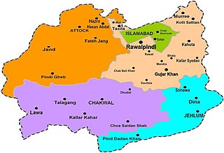
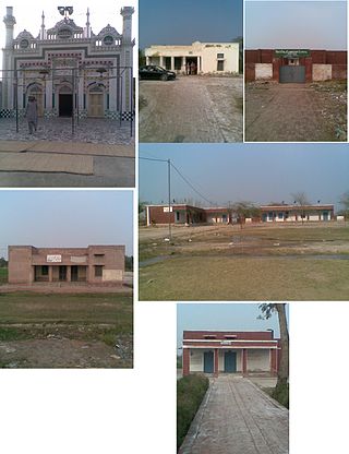
Bhata is a village in Pakistan which is located in the centre of Mandra-Chowk Pindori Road, Tehsil Gujar Khan, Rawalpindi District.
Shadan Lund is a small city in between Dera Ghazi Khan and Taunsa Shareef. Lund Is a Baloch tribe of Pakistan. Lund is Balochi word meaning "warrior".The Chief families are Saraiki speaking and are of Baloch descent.
Szymanów is a village in the administrative district of Gmina Ujazd, within Tomaszów Mazowiecki County, Łódź Voivodeship, in central Poland. It lies approximately 14 kilometres (9 mi) north-west of Tomaszów Mazowiecki and 36 km (22 mi) south-east of the regional capital Łódź.

Bolter End is a hamlet 5 mi (8.0 km) to the west of High Wycombe in Buckinghamshire, England.

Mačkatica is a village in the municipality of Surdulica, Serbia. According to the 2002 census, the village has a population of 259 people.
Buttar Sarinh, incorrect spellings include Buttar Shrin and Buttar Shri, is a small village in the Giddarbaha tehsil of Sri Muktsar Sahib district in Punjab, India. It's located on the Sri Muktsar Sahib-Bathinda national Highway 754.
Khichian is a village in the Faisalabad District, on Chiniot, Chak Jhumra road, Punjab, Pakistan. It is in Tehsil Chak Jhumra's Union Council # 04 and is 4 km away from the Faisalabad to Pindi Bhattian Motorway M4 Deputy Wala Interchange. Its Latitude is 31° 36' 27.83"N, and Longitude is 73° 07' 31.35"E. The people of Khichian use the M3 to commute, as it is 140 kilometers away from Lahore and 24 kilometers away from Faisalabad. Nearby towns are Faisalabad, Chak Jhumra, Chiniot, Pindi Bhattian. By road, Khichian is connected to Faisalabad, Barnala, Chak Jhumra, and Chiniot.
The village of Bhasaur is situated on state Highway No. 11 between Dhuri and Maler Kotla towns in Sangrur District of East Punjab. New Delhi is around 240 km and the state capital is 140 km away. Nearby villages include Ranchna (Rajinderapuri), Banbhauri, Babbanpur, Sangala, Sangali, Himtana (Lachabaddi).
Chak Sahbu is a small village in Jalandhar District of Punjab State, India. The village is administrated by Sarpanch who is elected representative of village. It is located 49 km towards East from Jalandhar, 14 km from Phillaur and 119 km from Chandigarh. The nearest census town and marketplace is located 1 km in Apra, Punjab. The nearest train station is situated 13.9 km away in Phillaur, nearest domestic airport is at Ludhiana and the nearest international airport is 143 km away in Amritsar.
Raipur Araiyan or Raipur Araian is a medium size village in Phillaur tehsil of Jalandhar District of Punjab State, India. It is situated on Phillaur Nawanshahr Road and located 5.6 km from Nagar, 12.6 km from Phillaur, 55.8 km from Jalandhar and 110 km from state capital Chandigarh. Raipur Araiyan has postal head office in Dayalpur which is 2.8 km away from the village. The village is administrated by a sarpanch who is an elected representative of village as per Panchayati raj (India).
Ratainda or Ratenda is a large village in Shaheed Bhagat Singh Nagar district of Punjab State, India. The village is administrated by a Sarpanch, who is the elected representative of the village. It is located 2.5 km (1.6 mi) from postal head office Moron, 6.3 km (3.9 mi) from census town Apra, 11.7 km (7.3 mi) from Shaheed Bhagat Singh Nagar and 113 km (70 mi) from Chandigarh.
Lasara is a village in Phillaur tehsil of Jalandhar District of Punjab State, India. It is located 17 km away from Phillaur, 60 km from Jalandhar and 108 km from state capital Chandigarh. The village is administrated by a Sarpanch, an elected representative of the village.

Bergama Museum is a museum in Bergama district of İzmir Province, Turkey.
