
The administrative units of Pakistan comprise four provinces, one federal territory, and two disputed territories: the provinces of Punjab, Sindh, Khyber Pakhtunkhwa, and Balochistan; the Islamabad Capital Territory; and the administrative territories of Azad Jammu and Kashmir and Gilgit–Baltistan. As part of the Kashmir conflict with neighbouring India, Pakistan has also claimed sovereignty over the Indian-controlled territories of Jammu and Kashmir and Ladakh since the First Kashmir War of 1947–1948, but has never exercised administrative authority over either region. All of Pakistan's provinces and territories are subdivided into divisions, which are further subdivided into districts, and then tehsils, which are again further subdivided into union councils.

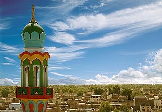
Dera Ghazi Khan, abbreviated as D.G. Khan, is a city in the southwestern part of Punjab, Pakistan. It is the 19th populous city of Pakistan. Lying west of the Indus River, it is the headquarters of Dera Ghazi Khan District and Dera Ghazi Khan Division.

Bahawalnagar, is the capital city of Bahawalnagar District in the Punjab province of Pakistan. The city of Bahawalnagar is the headquarter of the district and tehsil as well. It is the 54th largest city of Pakistan by population according to the 2017 census. Old name of Bahawalnagar was Rojanwali/Ubbha. It was named Bahawalnagar in 1904 after Bahawal Khan V, the ruler of the Bahawalpur state comprising the present districts of Bahawalpur, Bahawalnagar and Rahim Yar Khan. It is 262 km (163 mi) south of Lahore and about 175 km (109 mi) miles east of Bahawalpur. It is 65 km (40 mi) far from District Pakpattan. River Sutlej passes on the northern side at a distance of about 6 miles.
Layyah District, is a district in the Punjab, Pakistan. It is located in the southern part of the province. Layyah City is the district headquarter of Layyah District. Layyah has hot desert climate.

Barkhan is a district in the Pakistani province of Balochistan. It shares its borders with the province of Punjab to the east and the Balochistan districts of Dera Bugti to the south, Kohlu to the west, Loralai to the northwest and Musakhel to the north. The district's headquarters is the town of Barkhan. It was granted the status of a separate district on 31 December 1991, prior to which it was a tehsil within Loralai District.

Dera Ghazi Khan is a district in the Punjab province of Pakistan. Its capital is the Dera Ghazi Khan city.
Taunsa is a Tehsil (subdivision) of Taunsa District, Punjab, Pakistan. Its capital is Taunsa city.
Jatoi is a tehsil, an administrative subdivision, of Muzaffargarh District in Punjab, Pakistan. Its capital is Jatoi, and it is situated in the southern part of the Punjab province. The estimated population of Jatoi is 714,576.
Dera Ghazi Khan, is an administrative subdivision (tehsil) of Dera Ghazi Khan District in the Punjab province of Pakistan. The capital of the tehsil is Dera Ghazi Khan.
Kot Chutta is a tehsil administrative subdivision of Dera Ghazi Khan District in the Punjab Province of Pakistan. Kot Chutta is situated off the Indus Highway.
Nawan is a town and union council of Dera Ghazi Khan District in the Punjab province of Pakistan. It has an area of 796,095 km2. The currency is the Pakistani rupees.
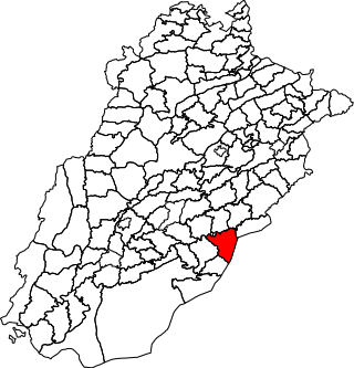
Bahawalnagar Tehsil is a tehsil located in Bahawalnagar District, Punjab, Pakistan. There are two towns in Bahawalnagar Tehsil: Bahawalnagar and Dunga Bunga. The city of Bahawalnagar is the headquarters of the tehsil which is administratively subdivided into 31 Union Councils.

Chistian Tehsil is a tehsil located in Bahawalnagar District, Punjab, Pakistan. The city of Chishtian is the headquarters of the tehsil which is administratively subdivided into 29 Union Councils.
Rahim Yar Khan Tehsil is an administrative subdivision (tehsil) of Rahim Yar Khan District in the Punjab province of Pakistan.

Khairpur Tamewali Tehsil is an administrative tehsil (subdivision" of Bahawalpur District in the Punjab province of Pakistan. The city of Khairpur Tamewali is the tehsil headquarters which is administratively subdivided into eight union councils.

Fort Abbas is a tehsil located in Bahawalnagar District, Punjab, Pakistan.
Lachi is one of the two tehsils in the Kohat District of Khyber Pakhtunkhwa province in Pakistan, located south of the district capital Kohat. It houses about 100,000 inhabitants, living in 1,161 square kilometres (448 sq mi). The tehsil is subdivided into nine union councils. About 40% of the working population is employed outside the tehsil.It is a rural area where most households' livelihood depends on remittances and subsistence farming. Education is provided through several private and government high schools, as well as a government degree college affiliated with Kohat University.
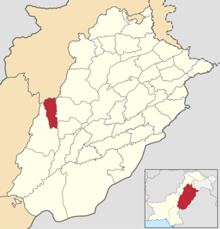
Taunsa District is a district in the Punjab province of Pakistan. It is a newly created district in 2022. Taunsa is primarily inhabited by Saraiki speaking Baloch people and Balochi speaking Balochs. Major tribes in district are Buzdar, Qaisrani, Nutkani and Khetran, these tribes form more than 90% of entire district population. It is situated on the bank of River Indus. Taunsa is an agricultural area known for its fertile land and crops. The eastern part of district consists of fertile planes irrigated by River Indus and its canal systems, while the western half comprises mountains of Koh e Sulaiman range.
Muzaffargarh Tehsil, is a tehsil of Muzaffargarh District that falls in DG Khan Division, in the Punjab province of Pakistan.