Yasouf (unofficial)"},"type":{"wt":"[[Village council (Palestinian Authority)|Municipality type D (Village council)]]"},"image_skyline":{"wt":"כפר יאסוף.jpg"},"image_caption":{"wt":""},"pushpin_map":{"wt":"Palestine"},"pushpin_map_caption":{"wt":"Location of Yasuf within [[Palestine]]"},"image_map":{"wt":""},"map_caption":{"wt":""},"coordinates":{"wt":"{{coord|32|06|32|N|35|14|20|E|region:PS|display=inline,title}}"},"grid_name":{"wt":"[[Palestine grid|Palestine grid]]"},"grid_position":{"wt":"172/168"},"subdivision_type":{"wt":"State"},"subdivision_name":{"wt":"[[State of Palestine]]"},"subdivision_type1":{"wt":"[[Governorates of the Palestinian National Authority|Governorate]]"},"subdivision_name1":{"wt":"[[Salfit Governorate|Salfit]]"},"established_title":{"wt":"Founded"},"established_date":{"wt":""},"government_footnotes":{"wt":""},"government_type":{"wt":"[[Village council (Palestinian Authority)|Village council]]"},"leader_title":{"wt":""},"leader_name":{"wt":""},"unit_pref":{"wt":"dunam"},"area_footnotes":{"wt":""},"area_total_km2":{"wt":"8.6"},"area_total_dunam":{"wt":"8550"},"elevation_footnotes":{"wt":"[http://vprofile.arij.org/salfit/pdfs/vprofile/Yasuf_vp_en.pdf Yasuf Village Profile], ARIJ, p. 4"},"elevation_m":{"wt":"575"},"elevation_min_m":{"wt":""},"elevation_max_m":{"wt":""},"population_footnotes":{"wt":"{{cite report |date=February 2018 |title=Preliminary Results of the Population, Housing and Establishments Census, 2017 |url=https://www.pcbs.gov.ps/Downloads/book2364-1.pdf |department=[[Palestinian Central Bureau of Statistics]] (PCBS) |publisher=[[State of Palestine]] |pages=64–82 |access-date=2023-10-24}}"},"population_total":{"wt":"2093"},"population_as_of":{"wt":"2017"},"population_note":{"wt":""},"population_density_km2":{"wt":"auto"},"blank_name_sec1":{"wt":"Name meaning"},"blank_info_sec1":{"wt":"from personal namePalmer, 1881, p. [https://archive.org/stream/surveyofwesternp00conduoft#page/250/mode/1up 250]"},"website":{"wt":""},"footnotes":{"wt":""}},"i":0}}]}" id="mwAg">Municipality type D in Salfit, State of Palestine
Yasuf | |
---|---|
Arabic transcription(s) | |
• Arabic | ياسوف |
• Latin | Yassuf (official) Yasouf (unofficial) |
![]() | |
Location of Yasuf within Palestine | |
Coordinates: 32°06′32″N35°14′20″E / 32.10889°N 35.23889°E | |
Palestine grid | 172/168 |
State | State of Palestine |
Governorate | Salfit |
Government | |
• Type | Village council |
Area | |
• Total | 8,550 dunams (8.6 km2 or 3.3 sq mi) |
Elevation | 575 m (1,886 ft) |
Population (2017) [2] | |
• Total | 2,093 |
• Density | 240/km2 (630/sq mi) |
Name meaning | from personal name [3] |
Yasuf (Arabic : ياسوف) is a Palestinian village in the Salfit Governorate of the State of Palestine, in the northern West Bank, northeast of Salfit, 37 kilometres (23 mi) southwest of Nablus and adjacent to the Israeli settlement of Kfar Tapuach. According to the Palestinian Central Bureau of Statistics, it had a population of 2,093 in 2017. [2] About 87% of the population relies on agriculture for income, while the remainder work in the public sector. [4]
Yasuf is 6 kilometers (3.7 mi) north-east of Salfit. It is bordered by Yatma and Za'tara to the east, As-Sawiya to the east and south, Iskaka to the south and west, Jamma'in to the west and north, and Huwwara to the north. [1]
Yasuf is an ancient village that is known from all periods. [5] Potsherds from the Iron Age II (8th and 7th centuries BCE), have been found, and also from the Hellenistic/Roman, Crusader/Ayyubid, Mamluk and early Ottoman era. [6] Byzantine ceramics have also been found. [7]
NE and SW of the village is a large cemetery, with tombs carved into rock, some with arcosolia. [7]
Yasuf is identified with the Israelite village of Yaashuv mentioned in the Samaria Ostraca. [8]
During the Roman period it was one of three important markets for fruits, grains and legumes in the northern Judean mountains, southern Samaria, and the region of Lod. [9]
The village is mentioned by its current name in the Samaritan Book of Joshua, and in the "Samaritan Chronicle", its name is recorded as Jusepheh. [10] [11] According to the former, a story recounts how two Samaritan brothers, Ephraim and Menashe of Yasuf, hosted a Jewish pilgrim for the night and swapped the doves the pilgrim intended to offer as a sacrifice in the Temple of Jerusalem with mice. When their actions were discovered, they were punished and forced into servitude in the Temple. [12] In a Samaritan text, the town was known to be inhabited by Samaritan High Priests. [13]
During the Crusader period Diya' al-Din (1173–1245) writes that there was a rural mosque in Yasuf, indicating that there was a significant Muslim population in the village at the time. [14] He also noted that followers of Ibn Qudamah lived here. [15]
Yakut (1179–1229) noted that Yasuf was a "village of Nabulus in the Filastin province. It is celebrated for its abundance of pomegranates." [16]
The village was incorporated into the Ottoman Empire in 1517 with all of Palestine, and in 1596 it appeared in the tax registers under the name of Yasuf ar-Rumman. It was in the Nahiya of Jabal Qubal of the Liwa of Nablus, with a population of 41 households and 8 bachelors, all Muslim. The villagers paid taxes on wheat, barley, summer crops, olives, goats and beehives; a total of 6,700 akçe. 1,5/24 of the revenue went to a Waqf. [17]
In the 18th and 19th centuries the village formed part of the highland region known as Jūrat ‘Amra or Bilād Jammā‘īn. Situated between Dayr Ghassāna in the south and the present Route 5 in the north, and between Majdal Yābā in the west and Jammā‘īn, Mardā and Kifl Ḥāris in the east, this area served, according to historian Roy Marom, "as a buffer zone between the political-economic-social units of the Jerusalem and the Nablus regions. On the political level, it suffered from instability due to the migration of the Bedouin tribes and the constant competition among local clans for the right to collect taxes on behalf of the Ottoman authorities." [18]
French explorer Victor Guérin visited the village in 1870, and he found it to have about 350 inhabitants. The village appeared ancient, with old masonry reused in houses and walls. The village had an excellent supply of water which was collected in a pool, near the steps down was a beautifully carved niche with a shell motif. This pool provided water for gardens of olive and pomegranate trees. [19]
In 1870/1871 (1288 AH) an Ottoman census listed the village in the nahiya (sub-district) of Jamma'in al-Thani, subordinate to Nablus. [20]
In the 1882 PEF's Survey of Western Palestine (SWP), Yasuf is described as, "an ancient village," located in a valley, with a Roman road passing nearby. [10] [21] Inside the village is "a good spring ... and olives. A beautiful garden of pomegranates exists north of the spring. The water comes out of a cleft in a cliff, near which is an ancient well with steps. There is a sacred place, with a large oak (Sindian), and a ruined shrine, south-west of the village, near 'Ain er Raja. There are drafted stones in many houses, and remains of well-built enclosures, now ruined. Many well-cut rock tombs are also found on either side." [10]
Also in the village were "rock-cut tombs with kokim [...]". A subterranean channel led out from the spring that contained small fish and there were pillar shafts there too. To the west of the village under an oak tree lay the ruins of a Maqam (shrine) for Sheikh Abu Hasan among the remains of other old drystone enclosures. To the north of the maqam was a rock-cut tomb, "with three loculi under arcosolia." Tombs also lay to the northeast and southwest with well-cut arched doors. In the valley to the northwest was a modern vault with a mihrab. [21]
In the 1922 census of Palestine conducted by the British Mandate authorities, Yasuf had a population of 172, all Muslims, [22] while in the 1931 census it had 61 occupied houses and a population of 257, still all Muslim. [23]
In the 1945 statistics the population was 360, all Muslims, [24] while the total land area was 6,068 dunams, according to an official land and population survey. [25] Of this, 928 were allocated for plantations and irrigable land, 1,991 for cereals, [26] while 35 dunams were classified as built-up areas. [27]
In the wake of the 1948 Arab–Israeli War, and after the 1949 Armistice Agreements, Yasuf came under Jordanian rule.
The Jordanian census of 1961 found 585 inhabitants here. [28]
Since the Six-Day War in 1967, Yasuf has been under Israeli occupation.
After the 1995 accords, 25.5% of village land is defined as Area B land, while the remainder 74.5% is Area C. Israel has made numerous confiscations of village land, including confiscating 602 dunums for the establishment of the Israeli settlement of Kfar Tapuah. [29]
On 11 December 2009, Yasuf's Al-Kabir Mosque was vandalized and burnt. [30] Israeli police suspect the action was undertaken by Israeli settlers. [31] Prayer carpets and holy books were destroyed in the fire, and the arsonists left behind graffiti reading, "We will burn all of you," and, "Prepare to pay the price." [31] A few months previous radical settlers declared that Palestinians in the West Bank would pay a "price tag" every time Israeli forces dismantled illegal Israeli settlement structures. [31] Following the incident, Israeli forces opened fire on 100 Palestinian residents of the village who were protesting the arson. [31]
In January 2010 the extremist settler Rabbi Yitzhak Shapira was arrested by the Israeli police for alleged involvement in the torching of the mosque. He denied any involvement, and was later released due to lack of evidence. [32] [33]
In April 2010 the settlers spray-painted elsewhere in the village the words "Thank you God, for not making me a Gentile". [34]
On October 6, 2014 Israeli settlers from Taffouh settlement ruined about 100 olive trees in Yasuf and 20 others in Burin, said Ghassan Daghlas, who is in charge of monitoring illegal settlers' activities in the area. [35]
Near Yasuf lies a significant archaeological tell known as Tell Abu Zarad. Positioned atop an dominating hill (PAL 171/167), it is home to a Muslim tomb-shrine dedicated to Sheikh Abu Zarad (or Abu az-Zurd). This location may be identified with a biblical named Tappuah, which is also associated with a place of the same name mentioned in a Qumran text. The majority of the potsherds found here date back to the Middle Bronze Age and Iron Age II. [36]
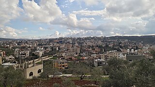
Salfit is a Palestinian city in the central West Bank, and the capital of the Salfit Governorate of the State of Palestine. Salfit is located at an altitude of 570 meters (1,870 ft), adjacent to the Israeli settlement of Ariel. According to the Palestinian Central Bureau of Statistics (PCBS), Salfit had a population of 10,911 in 2017. Since the 1995 Interim Agreement on the West Bank and the Gaza Strip, Salfit, located in Area A, has been administered by the Palestinian National Authority, while continuing under Israeli military occupation.
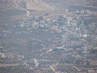
Kifl Haris is a Palestinian village in the northern West Bank, located six kilometers west of Salfit and 18 kilometers south of Nablus, in the Salfit Governorate of the State of Palestine; it is located northwest of the Israeli settlement of Ariel.
Deir Ballut is a Palestinian town in the Salfit Governorate in the northern West Bank, 41 kilometers (25 mi) south west of Nablus. According to the Palestinian Central Bureau of Statistics, it had a population of 3,873 in 2017.
Jamma'in is a Palestinian town in the Nablus Governorate of the State of Palestine, in the northern West Bank, located 16 kilometers (9.9 mi) southwest of Nablus, 6 kilometers (3.7 mi) northwest of Salfit and 40 kilometers (25 mi) north of Ramallah. According to the Palestinian Central Bureau of Statistics, the town had a population of 7,436 in 2017.
Kafr ad-Dik is a Palestinian town located 9.5 kilometers west of Salfit in the Salfit Governorate of Palestine, in the northern West Bank. According to the Palestinian Central Bureau of Statistics (PCBS), the town had a population of 5,551 in 2017.
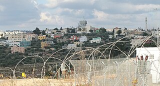
Bruqin is a Palestinian town 13 kilometers west of Salfit in the Salfit Governorate of the State of Palestine, in the northern West Bank, adjacent to the Israeli settlement of Brukhin, which was built over lands confiscated from the Palestinian town. According to the Palestinian Central Bureau of Statistics, Bruqin had a population of 4,047 in 2017. The town used to be on a camel-trading route. There is evidence of Roman rule in the city due to the presence of three ancient pools and a tomb.
Qarawat Bani Hassan is a Palestinian town in the Salfit Governorate of the state of Palestine, 30 kilometers southwest of Nablus and 8 kilometers northwest of Salfit in the northern West Bank. According to the Palestinian Central Bureau of Statistics, the town had a population of 5,513 in 2017.
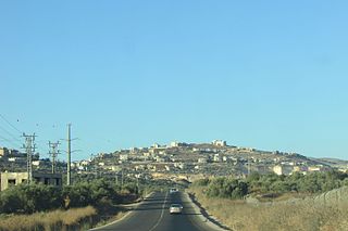
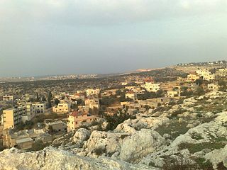
Biddya is a Palestinian city in the Salfit Governorate, located 32 kilometers southwest of Nablus and half that distance from Salfit in the northern West Bank. According to the Palestinian Central Bureau of Statistics (PCBS), Biddya had a population of 10,451 in 2017. The town is governed by a municipal council of eleven members who each represent the prominent families of Biddya and select a mayor.
Az-Zawiya is a Palestinian town in the Salfit Governorate of the State of Palestine, in the northern West Bank, located west of Salfit and south of Qalqilya. According to the Palestinian Central Bureau of Statistics, az-Zawiya had a population of 6,033 in 2017. The town's population is made up of primarily three families: Shuqeir (45%), Muqadi (30%) and Raddad (20%), while the remaining 5% consists of Palestinian refugee families such as Shamlawi, Rabi and Yusif.
Einabus is a Palestinian village in the northern West Bank, located 12 kilometers south of Nablus and a part of the Nablus Governorate. Nearby towns include Huwara and Beita to the east and Jammain to the south.
Salim is a Palestinian town in the northern West Bank, located six kilometers east of Nablus and is a part of the Nablus Governorate. According to the Palestinian Central Bureau of Statistics (PCBS), Salim had a population of 6,266 inhabitants in 2017.
Farkha is a Palestinian village in the Salfit Governorate in the northern West Bank, 30 kilometers south of Nablus. According to the Palestinian Central Bureau of Statistics, it had a population of 1,650 in 2017.
Haris is a Palestinian town in the Salfit Governorate of the State of Palestine, in the northern West Bank, 24 kilometers Southwest of Nablus. According to the Palestinian Central Bureau of Statistics, it had a population of 4,137 in 2017.
Marda is a Palestinian town in the Salfit Governorate of the State of Palestine, in the northern West Bank, 18 kilometers southwest of Nablus. According to the Palestinian Central Bureau of Statistics, it had a population of 2,375 in 2017.
Iskaka is a Palestinian town in the Salfit Governorate of the State of Palestine, in the northern West Bank, 27 kilometers southwest of Nablus. According to the Palestinian Central Bureau of Statistics, it had a population of 1,198 in 2017.
Qira is a Palestinian town in the Salfit Governorate in the northern West Bank, 19 kilometers southwest of Nablus. According to the Palestinian Central Bureau of Statistics, it had a population of approximately 1,278 in 2017.
Sarta is a Palestinian town in the Salfit Governorate in the northern West Bank, 22 kilometers southwest of Nablus. According to the Palestinian Central Bureau of Statistics, it had a population of approximately 3,382 in 2017.
Mas-ha is a Palestinian village in the Salfit Governorate in the northern West Bank, 24 kilometers southwest of Nablus. According to the Palestinian Central Bureau of Statistics, it had a population of 2,370 in 2017.
Burin is a Palestinian village in the Nablus Governorate of the State of Palestine, in the northern West Bank, located 7 kilometres (4.3 mi) southwest of Nablus. The town had a population of 2,844 in 2017.
As-Sawiya is a Palestinian town in the Nablus Governorate of the State of Palestine, in the northern West Bank, located 18 kilometers south of Nablus. According to the Palestinian Central Bureau of Statistics (PCBS), the town had a population of 2,761 inhabitants in 2017.