Yerranderie

Last updated

General view of Yerranderie Yerranderrie-village.jpg
General view of Yerranderie

Yerranderie is a ghost town located near Kanangra-Boyd National Park of New South Wales, Australia in Wollondilly Shire. [1]

Contents

History

Yerranderie was formerly a silver mining town of 2000 people, but the mining industry collapsed in 1927, and the town was cut off from direct access from Sydney by the establishment of the Warragamba Dam and Lake Burragorang in 1959. Country singer Frank Ifield immortalised the event with his song “Yerranderie”. The Yerranderie Post Office opened on 1 November 1899 and closed in 1958. [2]

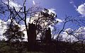
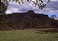
The town is now divided into two sections, the residential township adjacent to a private airstrip and the historic site one kilometre further west. The area is surrounded by abandoned mine shafts and mining relics. Accessible mainly by dirt road from Oberon, New South Wales 70 km to the west; another route passes through Oakdale, New South Wales to the east, but that road is closed to public access as it passes through a water catchment area. [3] Aircraft also occasionally fly out from Camden Airport. The township was established on the slopes north of Yerranderrie Peak, which is the remains of a volcanic dyke and the source of the mineral wealth of the area. The name of Yerranderrie is taken from two local Aboriginal words meaning "slope" and "summit".

Yerranderie was caught up in what was, at the time, the world's longest strike, lasting for eighteen months in 1919–1920. [4] The workers of this small mine belonged to the same union as those at Broken Hill. When the Broken Hill mine went on strike, the workers at Yerranderie were required to join that strike by their union. The strike, however, was not about any issue at Yerranderie.

The town was eventually bought by Valerie Anne Lhuede, who developed it as a tourist centre and total environment project. The old post office is now known as The Lodge and serves as a guest house. Other restored buildings include two miners cottages as well as several shops. The caretakers live in Krubi Cottage nearby. [5]

In March 2011, Lhuede announced, "I am donating Yerranderie to the National Parks and Wildlife Service with a list of my wishes for Yerranderie’s future."[ citation needed ]

See also

34°07′S150°13′E / 34.117°S 150.217°E / -34.117; 150.217

Related Research Articles

<span class="mw-page-title-main">Ku-ring-gai Chase National Park</span> Protected area in New South Wales, Australia

Ku-ring-gai Chase National Park is a national park on the northern side of Sydney in New South Wales, Australia. The 14,977-hectare (37,010-acre) park is 25 kilometres (16 mi) north of the Sydney central business district and generally comprises the land east of the M1 Pacific Motorway, south of the Hawkesbury River, west of Pittwater and north of Mona Vale Road. It includes Barrenjoey Headland on the eastern side of Pittwater.

<span class="mw-page-title-main">Nattai National Park</span> Protected area in New South Wales, Australia

The Nattai National Park is a protected national park that is located in the Macarthur and Southern Highlands regions of New South Wales, in Australia. 48,984-hectare (121,040-acre) It is situated approximately 150 kilometres (93 mi) southwest of the Sydney central business district and primarily encompasses the valley of the Nattai River, which is surrounded by large sandstone cliffs. Part of the Southern Highlands Shale Forest and Woodland, the park is covered in dry sclerophyll (hard-leafed) forest – mostly eucalypt and has fairly frequent forest fires. It is a largely untouched wilderness area, as it has no facilities and despite its closeness to Sydney, receives few visitors.

<span class="mw-page-title-main">Broken Hill</span> Town in New South Wales, Australia

Broken Hill is a city in the far west region of outback New South Wales, Australia. An inland mining city, is near the border with South Australia on the crossing of the Barrier Highway (A32) and the Silver City Highway (B79), in the Barrier Range. It is 315m above sea level, with a hot desert climate, and an average rainfall of 235mm. The closest major city is Mildura, 300 km to the south and the nearest State Capital City is Adelaide, the capital of South Australia, which is more than 500 km to the southwest and linked via route A32.

<span class="mw-page-title-main">Cobar</span> Town in New South Wales, Australia

Cobar is a town in central western New South Wales, Australia whose economy is based mainly upon base metals and gold mining. The town is 712 km (442 mi) by road northwest of the state capital, Sydney. It is at the crossroads of the Kidman Way and Barrier Highway. The town and the local government area, the Cobar Shire, are on the eastern edge of the outback. At the 2016 census, the town of Cobar had a population of 3,990. The Shire has a population of approximately 4,700 and an area of 44,065 square kilometres (17,014 sq mi).

<span class="mw-page-title-main">Burra, South Australia</span> Town in South Australia

Burra is a pastoral centre and historic tourist town in the mid-north of South Australia. It lies east of the Clare Valley in the Bald Hills range, part of the northern Mount Lofty Ranges, and on Burra Creek. The town began as a single company mining township that, by 1851, was a set of townships collectively known as "The Burra". The Burra mines supplied 89% of South Australia's and 5% of the world's copper for 15 years, and the settlement has been credited with saving the economy of the struggling new colony of South Australia. The Burra Burra Copper Mine was established in 1848 mining the copper deposit discovered in 1845. Miners and townspeople migrated to Burra primarily from Cornwall, Wales, Scotland and Germany. The mine first closed in 1877, briefly opened again early in the 20th century and for a last time from 1970 to 1981.

<span class="mw-page-title-main">Mount Victoria, New South Wales</span> Town in New South Wales, Australia

Mount Victoria is a village in the Blue Mountains of New South Wales, Australia. Mount Victoria is geographically the western most village and suburb of Greater Sydney on the great western highway in the City of Blue Mountains, located about 120 kilometres (75 mi) west-northwest by road from the Sydney central business district and at an altitude of about 1,052 metres (3,451 ft) AHD . The settlement had a population of 823 people at the 2011 Census.

Pillinger is an abandoned port and townsite in Kelly Basin, on the south eastern side of Macquarie Harbour on the West Coast of Tasmania.

<span class="mw-page-title-main">Ivanhoe, New South Wales</span> Town in New South Wales, Australia

Ivanhoe is a very small township on the Cobb Highway between the Lachlan and Darling rivers in New South Wales, Australia. It is located within the Central Darling Shire local government area. Ivanhoe functions as a service centre for the surrounding area. The township is characterised by a particularly wide main street. At the 2016 census, Ivanhoe had a population of 196 people.

<span class="mw-page-title-main">Kiandra, New South Wales</span> Town in New South Wales, Australia

Kiandra is an abandoned gold mining town and the birthplace of Australian skiing. The town is situated in the Snowy Mountains of New South Wales, Australia, in the Snowy Monaro Regional Council inside the Kosciuszko National Park. Its name is a corruption of Aboriginal 'Gianderra' for 'sharp stones for knives'. It was earlier called Gibson's Plains, named after a Dr. Gibson, a settler in the district in 1839. For a century, Kiandra was Australia's highest town.

The Macdonald River is a perennial river located in the Hunter and Outer Metropolitan Sydney regions of New South Wales, Australia. It is a part of the Hawkesbury-Nepean catchment.

<span class="mw-page-title-main">Tibooburra</span> Town in New South Wales, Australia

Tibooburra is a town in the far northwest of New South Wales, Australia, located 1,187 kilometres (738 mi) from the state capital, Sydney. It is most frequently visited by tourists on their way to Sturt National Park or on the way to or from Innamincka in South Australia and Birdsville in Queensland. At the 2016 census, Tibooburra had a population of 134. Although facilities in Tibooburra are quite limited, fuel, meals, and a range of accommodation options are available. All significant support services are based in Broken Hill.

<span class="mw-page-title-main">Appin, New South Wales</span> Town in New South Wales, Australia

Appin is a town on the south-west fringe of Sydney in the Macarthur Region in Tharawal country near its boundary with Gandangara country, New South Wales, Australia in Wollondilly Shire. It is situated about 16 kilometres (9.9 mi) south of Campbelltown and 35 kilometres (22 mi) northwest of Wollongong.

<span class="mw-page-title-main">The Oaks, New South Wales</span> Town in New South Wales, Australia

The Oaks is a town in the Macarthur Region of New South Wales, Australia in Wollondilly Shire on the south western edge of the Sydney Basin. The Oaks is located 82 kilometres (51 mi) south-west of Sydney via the Hume Highway, 13 kilometres (8 mi) west of Camden and 290m above sea-level. At the 2016 census, The Oaks and the surrounding area had a population of 2,525.

Yalwal is the site of a former gold mining town of the same name situated 29 km (18 mi) west of Nowra at the confluence of the Danjera and Yarramunmun Creeks which then forms Yalwal Creek which flows into the Shoalhaven River in New South Wales, Australia.

<span class="mw-page-title-main">Gulf Country</span> Queensland region

The Gulf Country or North West Queensland is the region of woodland and savanna grassland surrounding the Gulf of Carpentaria in north western Queensland and eastern Northern Territory on the north coast of Australia. The region is also called the Gulf Savannah. The Gulf Country is crossed by the Savannah Way highway.

<span class="mw-page-title-main">Adolphus William Copper Smelter</span> Historic site in Queensland, Australia

Adolphus William Copper Smelter is a heritage-listed former copper smelter and associated mining camp at Westwood and Oakey Creek in Rockhampton Region, Queensland, Australia. It was built in 1874. It was added to the Queensland Heritage Register on 13 May 2011.

<span class="mw-page-title-main">Hill End Historic Site</span> Historic site in New South Wales, Australia

Hill End Historic Site is a heritage-listed former gold rush town and now township at Hill End, Bathurst Region, New South Wales, Australia. It was added to the New South Wales State Heritage Register on 2 April 1999.

<span class="mw-page-title-main">First BHP Offices Chimney Ruin</span> Historic site in New South Wales, Australia

The First BHP Offices Chimney Ruin is the heritage-listed ruin of the original offices of BHP, now located on Willyama Common, east of the corner of Gaffney and Oxide Streets, Proprietary Square, Broken Hill, City of Broken Hill, New South Wales, Australia. The original offices were built in 1885 by Tom Phin and A. W. B. Orman. It is also known as Site of first BHP Offices, BHP Fireplaces and Chimney ruins. The property is owned by Broken Hill City Council. It was added to the New South Wales State Heritage Register on 23 April 2010.

<span class="mw-page-title-main">Catherine Hill Bay Cultural Precinct</span> Historic site in New South Wales, Australia

Catherine Hill Bay Cultural Precinct is a heritage-listed company town at Catherine Hill Bay, City of Lake Macquarie, New South Wales, Australia. It was added to the New South Wales State Heritage Register on 5 November 2010.

<span class="mw-page-title-main">Hartley historic site</span> Historic site in New South Wales, Australia

Hartley historic site is a heritage-listed historic village located adjacent to the Great Western Highway, Hartley, City of Lithgow, New South Wales, Australia. It was built from 1837 to 1850. It is also known as Hartley Historic Site and Hartley Township. The property is owned and protected by Office of Environment and Heritage, an agency of the Government of New South Wales. It was added to the New South Wales State Heritage Register on 2 April 1999.

References

  1. Gregory's New South Wales State Road Map, Map 220, 11th Edition, published by Gregory's Publishing Company
  2. Premier Postal History. "Post Office List". Premier Postal Auctions. Retrieved 26 May 2011.
  3. Gregory's New South Wales State Map[ volume & issue needed ]
  4. "Broken Hill's Big Strike – The Personal Diary of Jack Cogan" . Retrieved 21 February 2019.
  5. Sydney and Blue Mountains Bushwalks, Neil Paton (Kangaroo Press) 2004, pp.316-318