Related Research Articles

Walnut Shade is an unincorporated community in Taney County, Missouri, United States. It is located approximately six miles northwest of Forsyth on U.S. Route 160. The town sits at the confluence of Bull and Bear Creeks. Walnut Shade is part of the Branson, Missouri Micropolitan Statistical Area.
Taberville is an unincorporated community in southwestern St. Clair County, Missouri, United States. It is located approximately sixteen miles west of Osceola, situated on the north side of the Osage River. Taberville formerly had a post office, but it has closed and mail is now delivered from nearby Rockville.

Reger is an unincorporated community in Sullivan County, Missouri, United States. It is located on Route 6, approximately six miles southwest of Milan.

Millersville is an unincorporated community in western Cape Girardeau County, Missouri, United States. It is located six miles (10 km) west of Jackson on Route 72.
Newland is an unincorporated community in northeast Pettis County, in the U.S. state of Missouri. The community is on Missouri Route EE approximately eight miles northeast of Sedalia.

Postal is an unincorporated community in Pettis County, Missouri, United States. It is located at 38°53′51″N93°5′0″W, and its altitude is 823 feet (251 m).
Ohio is an unincorporated community in northern St. Clair County, in the U.S. state of Missouri. The community is at the intersection of Missouri routes A and F and south of Cooper Creek. Lowry City is on Missouri Route 13 approximately seven miles to the east and Appleton City is approximately nine miles to the west-northwest on Missouri Route 52.
Garrett is an extinct town in eastern Callaway County, in the U.S. state of Missouri. The community and Garrett Cemetery are on Missouri Route K, one-half mile west of the Callaway-Montgomery county line. The community of Readsville is approximately 3.5 miles to the west and Americus is about 4.5 miles to the east on route K.
Wood Hill is an unincorporated community in Dallas County, in the U.S. state of Missouri. The community is located on Missouri Route 64, approximately 1.5 miles east of Pumpkin Center and Missouri Route 73. Buffalo is seven miles south-southwest. The headwaters of the Little Niangua River arise just east of the location.
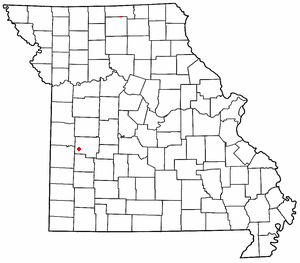
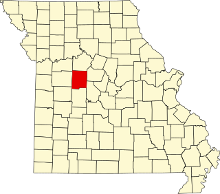
Finey is an unincorporated community in Henry County, in the U.S. state of Missouri.
Garland is an unincorporated community in Henry County, in the U.S. state of Missouri. The community is on an abandoned railroad line in an old coal mining area, approximately six miles northwest of Clinton, just east of Missouri Route O.
Huntingdale is an unincorporated community in Henry County, in the U.S. state of Missouri.
Mount Zion is an unincorporated community in Henry County, in the U.S. state of Missouri.
Piper is an unincorporated community in Henry County, in the U.S. state of Missouri. The community is on Missouri Route K and the northeast side of Granddaddy Creek. Clinton is approximately 12 miles to the east and Montrose Lake and the Montrose Consevation Area is two miles to the southeast on the Deepwater River.
Quarles is an unincorporated community in Henry County, in the U.S. state of Missouri. The community is located at the intersection of Missouri routes 13 and N, approximately six miles north of Clinton.
Roseland is an unincorporated community in Henry County, in the U.S. state of Missouri.
Karlin is an unincorporated community in central Polk County, in the Ozarks of southwest Missouri, United States.
Iuka Springs is an extinct town in St. Clair County, in the U.S. state of Missouri. The GNIS classifies it as a populated place.
Day is an unincorporated community in Taney County, in the Ozarks of southern Missouri. Day is located in the northwest part of the county, just south of the Taney-Christian county line on Missouri Route 176 and approximately one mile west of U.S. Route 65.
Conklin is an unincorporated community in western Webster County, in the U.S. state of Missouri. Conklin is located on Missouri Route 38, approximately six miles northwest of Marshfield. Elkland lies about four miles north on Route 38.
References
- ↑ U.S. Geological Survey Geographic Names Information System: Yolo, Missouri
- ↑ Calhoon East, MO, 7.5 Minute Topographic Quadrangle, USGS, 1953 (1983 rev.)
- ↑ "Henry County". Jim Forte Postal History. Retrieved 4 February 2015.
- ↑ U.S. Geological Survey Geographic Names Information System: Yolo Post Office (historical)
- ↑ "Henry County Place Names, 1928–1945 (archived)". The State Historical Society of Missouri. Archived from the original on 24 June 2016. Retrieved 6 October 2016.
Municipalities and communities of Henry County, Missouri, United States | ||
|---|---|---|
| Cities |  | |
| Villages | ||
| Townships | ||
| CDP | ||
| Other unincorporated communities | ||
| Ghost town | ||
| Footnotes | ‡This populated place also has portions in an adjacent county or counties | |
Coordinates: 38°25′58″N93°32′20″W / 38.43278°N 93.53889°W
| This Henry County, Missouri state location article is a stub. You can help Wikipedia by expanding it. |