Hartwell, Missouri

Last updated
Hartwell, Missouri
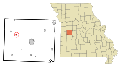
Henry County Missouri Incorporated and Unincorporated areas Hartwell Highlighted.svg
Location of Hartwell, Missouri
Coordinates: 38°25′59″N93°56′03″W / 38.43306°N 93.93417°W / 38.43306; -93.93417 Coordinates: 38°25′59″N93°56′03″W / 38.43306°N 93.93417°W / 38.43306; -93.93417
Country United States
State Missouri
County Henry
Area
[1]
  Total0.48 sq mi (1.23 km2)
  Land0.47 sq mi (1.23 km2)
  Water0.00 sq mi (0.00 km2)
Elevation
[2]
758 ft (231 m)
Population
 (2020)
  Total15
  Density31.58/sq mi (12.20/km2)
Time zone UTC-6 (Central (CST))
  Summer (DST) UTC-5 (CDT)
ZIP code
64788
Area code 660
FIPS code 29-30772 [3]
GNIS feature ID2587077 [2]

Hartwell is a former village and census-designated place in Henry County, Missouri, United States. The population was 16 at the 2010 census.

Contents

History

A post office called Hartwell was established in 1887, and remained in operation until 1968. [4] The village was named after a railroad official. [5] Hartwell disincorporated in 1995. [6]

Geography

According to the United States Census Bureau, the CDP has a total area of 0.48 square miles (1.24 km2), all land. [7]

Demographics

Historical population
CensusPop.Note
2020 15
U.S. Decennial Census [8]

2010 census

As of the census [9] of 2010, there were 16 people, 4 households, and 4 families living in the CDP. The population density was 33.3 inhabitants per square mile (12.9/km2). There were 5 housing units at an average density of 10.4 per square mile (4.0/km2). The racial makeup of the CDP was 100.0% White.

There were 4 households, of which 50.0% had children under the age of 18 living with them, 75.0% were married couples living together, and 25.0% had a female householder with no husband present. 0.0% of all households were made up of individuals. The average household size was 4.00 and the average family size was 4.00.

The median age in the CDP was 34 years. 25% of residents were under the age of 18; 18.8% were between the ages of 18 and 24; 12.6% were from 25 to 44; 37.6% were from 45 to 64; and 6.3% were 65 years of age or older. The gender makeup of the CDP was 50.0% male and 50.0% female.

2000 census

As of the census [3] of 2000, there were 16 people, 5 households, and 3 families living in the village. The population density was 33.6 inhabitants per square mile (13.0/km2). There were 5 housing units at an average density of 10.5/sq mi (4.0/km2). The racial makeup of the village was 93.75% White, 6.25% from other races. Hispanic or Latino of any race were 6.25% of the population.

There were 5 households, out of which 60.0% had children under the age of 18 living with them, 60.0% were married couples living together, and 40.0% were non-families. 40.0% of all households were made up of individuals, and 20.0% had someone living alone who was 65 years of age or older. The average household size was 3.20 and the average family size was 4.67.

In the village, the population was spread out, with 50.0% under the age of 18, 6.3% from 18 to 24, 31.3% from 25 to 44, 6.3% from 45 to 64, and 6.3% who were 65 years of age or older. The median age was 18 years. For every 100 females, there were 100.0 males. For every 100 females age 18 and over, there were 100.0 males.

The median income for a household in the village was $9,375, and the median income for a family was $30,417. Males had a median income of $21,250 versus $8,750 for females. The per capita income for the village was $4,216. There are 40.0% of families living below the poverty line and 44.0% of the population, including 40.0% of those under 18 and none of those over 64.
Related Research Articles

<span class="mw-page-title-main">Blue Ridge, Alabama</span> Census-designated place in Alabama, United States

Blue Ridge is an unincorporated community and census-designated place (CDP) in Elmore County, Alabama, United States. At the 2020 census, the population was 1,485. It is part of the Montgomery Metropolitan Statistical Area.

<span class="mw-page-title-main">Rock Creek, Alabama</span> CDP in Alabama, United States

Rock Creek is a census-designated place in Jefferson County, Alabama, United States. Its location is northwest of Hueytown. At the 2020 census, the population was 1,471. This area was damaged by an F5 tornado on April 8, 1998. An EF2 tornado struck northwest from here on January 23, 2012.

<span class="mw-page-title-main">Underwood-Petersville, Alabama</span> Census-designated place in Alabama, United States

Underwood-Petersville is a census-designated place (CDP) in Lauderdale County, Alabama United States. It is part of the Florence - Muscle Shoals Metropolitan Statistical Area known as "The Shoals". As of the 2010 census, the population of the CDP is 3,247.

<span class="mw-page-title-main">Kachina Village, Arizona</span> CDP in Coconino County, Arizona

Kachina Village is a census-designated place (CDP) in Coconino County, Arizona, United States. The population was 2,622 at the 2010 census. Kachina Village is primarily a bedroom community for Flagstaff.

<span class="mw-page-title-main">Alpine Village, California</span> Census-designated place in California, United States

Alpine Village is a census-designated place (CDP) in Alpine County, California, United States. The population was 114 at the 2010 census, down from 136 at the 2000 census.

<span class="mw-page-title-main">Mayflower Village, California</span> Census-designated place in California, United States

Mayflower Village is a census-designated place (CDP) in the San Gabriel Valley, in Los Angeles County, California, United States. The population was 5,515 at the 2010 census, up from 5,081 at the 2000 census. The ZIP Codes serving the community are 91006, which is served by Arcadia and 91016, which is served by Monrovia.

Heritage Village is a census-designated place (CDP) in the town of Southbury in New Haven County, Connecticut, United States. The population was 3,736 at the 2010 census.

Reed Creek is a census-designated place (CDP) in Hart County, Georgia, United States. The population was 2,604 at the 2010 census, up from 2,148 at the 2000 census.

<span class="mw-page-title-main">Hayward, Missouri</span> Census-designated place in Missouri, United States

Hayward is a census-designated place and former village in Pemiscot County, Missouri, United States. The population was 131 at the 2010 census.

<span class="mw-page-title-main">Biehle, Missouri</span> Census-designated place in Missouri, United States

Biehle was a village in Perry County, Missouri, United States. The population was 47 at the 2020 census. The community was founded in 1876 and named after the Biehle family.

<span class="mw-page-title-main">Yorketown, New Jersey</span> Census-designated place in New Jersey, United States

Yorketown is an unincorporated community and census-designated place (CDP) within Manalapan Township, in Monmouth County, New Jersey, United States. At the 2020 census, the CDP's population was 6,739.

<span class="mw-page-title-main">Crestwood Village, New Jersey</span> Census-designated place in New Jersey, United States

Crestwood Village is an unincorporated community and census-designated place (CDP) located within Manchester Township, in Ocean County, New Jersey, United States. As of the 2010 United States Census, the CDP's population was 7,907.

<span class="mw-page-title-main">Leisure Village, New Jersey</span> Census-designated place in New Jersey, United States

Leisure Village is an unincorporated community and census-designated place (CDP) located within Lakewood Township, in Ocean County, New Jersey, United States. As of the 2010 United States Census, the CDP's population was 4,400. The sprawling active adult community is also locally known as "Original" Leisure Village because it was the first of three neighboring active adult communities bearing similar names. Leisure Village East, and Leisure Village West are the other two communities nearby. Original Leisure Village (OLV) is also referred to by the moniker "The Village of Seven Lakes."

<span class="mw-page-title-main">Leisure Village East, New Jersey</span> Census-designated place in New Jersey, United States

Leisure Village East is an unincorporated community and census-designated place (CDP) located within Lakewood Township, in Ocean County, New Jersey, United States. As of the 2010 United States Census, the CDP's population was 4,217. Leisure Village East is one of several active adult communities bearing similar names. Leisure Village and Leisure Village West are the other two communities nearby.

<span class="mw-page-title-main">Limaville, Ohio</span> Census-designated place in Ohio, United States

Limaville is a census-designated place (CDP) and former village in Stark County, Ohio, United States. The population was 151 at the 2010 census. It is part of the Canton–Massillon Metropolitan Statistical Area.

<span class="mw-page-title-main">Labish Village, Oregon</span> Unincorporated community in the state of Oregon, United States

Labish Village is a census-designated place (CDP) in Marion County, Oregon, United States. The population was 454 at the 2020 census. It is part of the Salem Metropolitan Statistical Area.

<span class="mw-page-title-main">Northlake, South Carolina</span> Census-designated place in South Carolina, United States

Northlake is a census-designated place (CDP) in Anderson County, South Carolina, United States. The population was 3,745 at the 2010 census.

<span class="mw-page-title-main">Chehalis Village, Washington</span> Former CDP in Washington, United States

Chehalis Village is a former census-designated place (CDP) in Grays Harbor County, Washington, United States. The population was 346 at the 2000 census. The area was no longer listed as a CDP for the 2010 census.

<span class="mw-page-title-main">Eastchester (CDP), New York</span> CDP in New York, United States

Eastchester is a census-designated place (CDP) in Westchester County, New York, United States. The population was 19,554 at the 2010 census. The Eastchester CDP consists of the Town of Eastchester excluding the villages of Bronxville and Tuckahoe.

<span class="mw-page-title-main">Windsor, Wisconsin</span> Village in Wisconsin, United States

Windsor is a village and former town in Dane County, Wisconsin. The population was 8,754 at the time of the 2020 census. The communities of Lake Windsor, Morrisonville, and Token Creek are located within the village. Windsor voted to incorporate as a village on November 3, 2015; prior to its incorporation, it was a town, and a portion of the town was a census-designated place. Windsor is a part of the Census Bureau's Madison metropolitan statistical area.

References

  1. "ArcGIS REST Services Directory". United States Census Bureau. Retrieved August 28, 2022.
  2. 1 2 U.S. Geological Survey Geographic Names Information System: Hartwell, Missouri
  3. 1 2 "U.S. Census website". United States Census Bureau . Retrieved 2008-01-31.
  4. "Post Offices". Jim Forte Postal History. Retrieved 5 October 2016.
  5. "Henry County Place Names, 1928–1945 (archived)". The State Historical Society of Missouri. Archived from the original on 24 June 2016. Retrieved 5 October 2016.{{cite web}}: CS1 maint: bot: original URL status unknown (link)
  6. "Boundary Changes".
  7. "US Gazetteer files 2010". United States Census Bureau . Retrieved 2012-07-08.
  8. "Census of Population and Housing". Census.gov. Retrieved June 4, 2016.
  9. "U.S. Census website". United States Census Bureau . Retrieved 2012-07-08.