Brownington, Missouri

Last updated

Brownington, Missouri
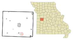
Henry County Missouri Incorporated and Unincorporated areas Brownington Highlighted.svg
Location of Brownington, Missouri
Coordinates: 38°14′43″N93°43′22″W / 38.24528°N 93.72278°W / 38.24528; -93.72278
Country United States
State Missouri
County Henry
Area
[1]
  Total0.12 sq mi (0.31 km2)
  Land0.12 sq mi (0.31 km2)
  Water0.00 sq mi (0.00 km2)
Elevation
[2]
748 ft (228 m)
Population
 (2020)
  Total71
  Density586.78/sq mi (226.14/km2)
Time zone UTC-6 (Central (CST))
  Summer (DST) UTC-5 (CDT)
FIPS code 29-08902 [3]
GNIS feature ID2396610 [2]
Websiteno website

Brownington is a town in Henry County, Missouri, United States. The population was 107 at the 2010 census.

Contents

History

The town of Brownington was first located in the year 1869, and joined that of Consville and was laid out by William N. Doyle. Consville, however, was founded in 1867, but the two communities have since merged. [4]

Geography

According to the United States Census Bureau, the city has a total area of 0.12 square miles (0.31 km2), all land. [5]

Demographics

Historical population
CensusPop.Note
1880 251
1890 32931.1%
1900 40723.7%
1910 348−14.5%
1920 333−4.3%
1930 266−20.1%
1940 261−1.9%
1950 179−31.4%
1960 130−27.4%
1970 95−26.9%
1980 11217.9%
1990 84−25.0%
2000 11941.7%
2010 107−10.1%
2020 71−33.6%
U.S. Decennial Census [6]

2010 census

As of the census [7] of 2010, there were 107 people, 45 households, and 32 families living in the city. The population density was 891.7 inhabitants per square mile (344.3/km2). There were 50 housing units at an average density of 416.7 per square mile (160.9/km2). The racial makeup of the city was 95.3% White, 2.8% Native American, and 1.9% from two or more races.

There were 45 households, of which 24.4% had children under the age of 18 living with them, 46.7% were married couples living together, 17.8% had a female householder with no husband present, 6.7% had a male householder with no wife present, and 28.9% were non-families. 24.4% of all households were made up of individuals, and 4.4% had someone living alone who was 65 years of age or older. The average household size was 2.38 and the average family size was 2.84.

The median age in the city was 46.8 years. 22.4% of residents were under the age of 18; 5.6% were between the ages of 18 and 24; 20.5% were from 25 to 44; 33.6% were from 45 to 64; and 17.8% were 65 years of age or older. The gender makeup of the city was 49.5% male and 50.5% female.

2000 census

As of the census [3] of 2000, there were 119 people, 45 households, and 32 families living in the town. The population density was 811.1 inhabitants per square mile (313.2/km2). There were 68 housing units at an average density of 463.5 per square mile (179.0/km2). The racial makeup of the town was 95.80% White, 1.68% African American and 2.52% Native American.

There were 45 households, out of which 28.9% had children under the age of 18 living with them, 64.4% were married couples living together, 4.4% had a female householder with no husband present, and 26.7% were non-families. 15.6% of all households were made up of individuals, and 11.1% had someone living alone who was 65 years of age or older. The average household size was 2.64 and the average family size was 3.00.

In the town the population was spread out, with 24.4% under the age of 18, 5.9% from 18 to 24, 21.0% from 25 to 44, 31.9% from 45 to 64, and 16.8% who were 65 years of age or older. The median age was 42 years. For every 100 females, there were 98.3 males. For every 100 females age 18 and over, there were 109.3 males.

The median income for a household in the town was $17,250, and the median income for a family was $27,750. Males had a median income of $18,750 versus $15,500 for females. The per capita income for the town was $8,174. There were 16.1% of families and 21.1% of the population living below the poverty line, including 20.6% of under eighteens and 32.1% of those over 64.
Related Research Articles

<span class="mw-page-title-main">Caswell, Maine</span> Town in the state of Maine, United States

Caswell is a town in Aroostook County, Maine, United States. The population was 293 at the 2020 census.

<span class="mw-page-title-main">Crystal, Maine</span> Town in the state of Maine, United States

Crystal is a town in Aroostook County, Maine, United States. The population was 248 at the 2020 census.

<span class="mw-page-title-main">Grand Isle, Maine</span> Town in the state of Maine, United States

Grand Isle is a town in Aroostook County, Maine, United States. The population was 366 at the 2020 census. The village of Grand Isle is in the northwestern part of the town.

<span class="mw-page-title-main">Masardis, Maine</span> Town in the state of Maine, United States

Masardis is a town in Aroostook County, Maine, United States. The population was 204 at the 2020 census.

<span class="mw-page-title-main">New Canada, Maine</span> Town in the state of Maine, United States

New Canada is a town in Aroostook County, Maine, United States. The population was 310 at the 2020 census.

<span class="mw-page-title-main">Sherman, Maine</span> Town in the state of Maine, United States

Sherman is a town in Aroostook County, Maine, United States. The population was 815 at the 2020 census.

Otis is a town in Hancock County, Maine, United States. The population was 673 at the 2020 census.

<span class="mw-page-title-main">Benton, Maine</span> Town in the state of Maine, United States

Benton is a town in Kennebec County, Maine, United States. It was formed in 1842, as a subdivision of the town of Clinton. The population was 2,715 at the 2020 census. The town was named for Missouri Senator Thomas Hart Benton.

Stoneham is a town in Oxford County, Maine, United States. The population was 261 at the 2020 census.

<span class="mw-page-title-main">Stow, Maine</span> Town in the state of Maine, United States

Stow is a town in Oxford County, Maine, United States. The population was 393 at the 2020 census.

<span class="mw-page-title-main">Upton, Maine</span> Town in the state of Maine, United States

Upton is a town in Oxford County, Maine, United States. The population was 69 at the 2020 census.

Alton is a town in Penobscot County, Maine, United States. It is part of the Bangor Metropolitan Statistical Area. The population was 829 at the 2020 census. The community is named after an Alton in England.

Chester is a town in Penobscot County, Maine, United States. The population was 549 at the 2020 census.

<span class="mw-page-title-main">Clifton, Maine</span> Town in the state of Maine, United States

Clifton is a town in Penobscot County, Maine, United States. The population was 840 at the 2020 census. It is part of the Bangor Metropolitan Statistical Area.

Newburgh is a town in Penobscot County, Maine, United States. The population was 1,595 at the time of the 2020 census.

Springfield is a town in Penobscot County, Maine, United States. The population was 293 at the 2020 census.

Alexander is a town in Washington County, Maine, United States. The population was 525 at the 2020 census. The town is named for Alexander Baring, 1st Baron Ashburton, the British negotiator of the Webster–Ashburton Treaty which ended the Aroostook War in 1838–1839.

<span class="mw-page-title-main">Oakvale, West Virginia</span> Town in West Virginia, United States

Oakvale is a town in Mercer County, West Virginia, United States, along the East River. The population was 137 at the 2020 census. It is part of the Bluefield, WV-VA micropolitan area which has a population of 107,578.

<span class="mw-page-title-main">Auburn, West Virginia</span> Town in West Virginia, United States

Auburn is a town in Ritchie County, West Virginia, United States. The population was 80 at the 2020 census.

<span class="mw-page-title-main">Dixon, Wyoming</span> Town in Wyoming, United States

Dixon is a town in Carbon County, Wyoming, United States. The population was 97 at the 2010 census.

References

  1. "ArcGIS REST Services Directory". United States Census Bureau. Retrieved August 28, 2022.
  2. 1 2 U.S. Geological Survey Geographic Names Information System: Brownington, Missouri
  3. 1 2 "U.S. Census website". United States Census Bureau . Retrieved January 31, 2008.
  4. "Henry County Place Names, 1928–1945 (archived)". The State Historical Society of Missouri. Archived from the original on June 24, 2016. Retrieved October 4, 2016.{{cite web}}: CS1 maint: bot: original URL status unknown (link)
  5. "US Gazetteer files 2010". United States Census Bureau. Archived from the original on July 2, 2012. Retrieved July 8, 2012.
  6. "Census of Population and Housing". Census.gov. Retrieved June 4, 2015.
  7. "U.S. Census website". United States Census Bureau . Retrieved July 8, 2012.