York Township, Steuben County, Indiana

Last updated

York Township
Indiana-Michigan-Ohio Tri-Point Marker.jpg
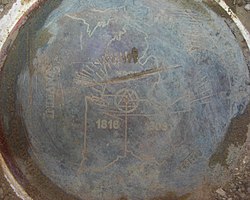
The brass disc officially marking Indiana's border with Michigan and Ohio
Map highlighting York Township, Steuben County, Indiana.svg
Location in Steuben County
Coordinates: 41°39′28″N84°50′37″W / 41.65778°N 84.84361°W / 41.65778; -84.84361
Country United States
State Indiana
County Steuben
Government
  Type Indiana township
Area
  Total22.19 sq mi (57.5 km2)
  Land22.19 sq mi (57.5 km2)
  Water0 sq mi (0 km2)  0%
Elevation
[1]
984 ft (300 m)
Population
 (2020) [2]
  Total710
  Density33/sq mi (13/km2)
Time zone UTC-5 (Eastern (EST))
  Summer (DST) UTC-4 (EDT)
Area code 260
GNIS feature ID 454070

York Township is one of twelve townships in Steuben County, Indiana, United States. As of the 2020 census, its population was 710, down from 733 at 2010, [3] and it contained 293 housing units. York Township has the distinction of being Indiana's lone township to border both Michigan and Ohio as well as bordering two states on land as all other tri-points along Indiana's border are underwater.

Contents

Geography

According to the 2010 census, the township has a total area of 22.19 square miles (57.5 km2), all land. [3] The streams of Hanselman Branch and West Branch Fish Creek run through this township.

Unincorporated towns

(This list is based on USGS data and may include former settlements.)

Cemeteries

The township contains three cemeteries: Dygert, York, and Powers. [4]

Major highways

History

The Powers Church was built in 1876 on land donated by the Powers family. Restored in the 1970s, it was added to the National Register of Historic Places in 1983. Monthly non-denominational services are held in the summer. Powers Church IN USA.jpg
The Powers Church was built in 1876 on land donated by the Powers family. Restored in the 1970s, it was added to the National Register of Historic Places in 1983. Monthly non-denominational services are held in the summer.

In the decades before it was settled by white immigrants, York Township and the surrounding area were the domain of the Potawatomi Indians.

The first recorded white settler in York Township was Fayette Barron, who built a homestead at what would become Metz in 1836. The following year saw the arrival of the Powers families, who settled in the northwest sections of the township. Two Powers brothers had scouted the area the year before, and now brought six families on a long journey from New York state. [5]

In 1879, the Powers families and neighbors built what is now known as the Powers Church. [5] The land for a nondenominational church (hence its other name "Free Church") had been donated in 1839 by Clark Powers, head of one of the original Powers families. The last regular services were held at the church in the 1920s. [6] The church was restored in 1976 and added to the National Register of Historic Places in 1983.

The unincorporated village of Metz enjoyed its heyday during the late 19th and early 20th centuries. At one point or another it boasted a sawmill, a hotel, physicians, an undertaker, and several of the more typical retail shops. [7] In 1919, the York township schools were consolidated with those of Richland Township into the Metz school. This school, with students from kindergarten through high school, operated for 40 years, until it was closed in 1959, a victim of declining enrollment. [7]

Education

York Township residents may obtain a free library card from the Carnegie Public Library of Steuben County. [8]

Related Research Articles

<span class="mw-page-title-main">Hillsdale County, Michigan</span> County in Michigan, United States

Hillsdale County is a county located in the U.S. state of Michigan. As of the 2020 Census, the population was 45,746. The county seat is Hillsdale. Hillsdale County is the only county in Michigan to border both Indiana and Ohio. Due to an angle in the state's southern border, Hillsdale County has the southernmost point in the state. Hillsdale County is conterminous with the Hillsdale, MI Micropolitan Statistical Area. The Hillsdale County Courthouse was designed by Claire Allen, a prominent southern Michigan architect.

<span class="mw-page-title-main">Steuben County, Indiana</span> County in Indiana, United States

Steuben County is a county in the northeast corner of the U.S. state of Indiana. As of the 2020 United States Census the county population was 34,435. The county seat is Angola. Steuben County comprises the Angola, IN Micropolitan Statistical Area.

<span class="mw-page-title-main">Angola, Indiana</span> City in Indiana, United States

Angola is a city in Pleasant Township, Steuben County, Indiana, United States. The population was 8,612 at the 2010 census. The city is the county seat of Steuben County. Angola was founded by Thomas Gale and Cornelius Gilmore on June 28, 1838, and is home to Trine University. The town is served by I-69 and the Indiana Toll Road.

<span class="mw-page-title-main">Wayne Township, Starke County, Indiana</span> Township in Indiana, United States

Wayne Township is one of nine townships in Starke County, in the U.S. state of Indiana. As of the 2020 census, its population was 4,609 and it contained 2,010 housing units.

<span class="mw-page-title-main">Clay Township, St. Joseph County, Indiana</span> Township in Indiana, United States

Clay Township is one of 13 townships in St. Joseph County, in the U.S. state of Indiana. As of the 2020 census, its population was 34,235.

<span class="mw-page-title-main">Olive Township, St. Joseph County, Indiana</span> Township in Indiana, United States

Olive Township is one of thirteen townships in St. Joseph County, in the U.S. state of Indiana. As of the 2000 census, its population was 3,914.

<span class="mw-page-title-main">Cedar Creek Township, Allen County, Indiana</span> Township in Indiana, United States

Cedar Creek Township is one of twenty townships in Allen County, Indiana, United States. As of the 2020 census, its population was 13,684.

<span class="mw-page-title-main">Jackson Township, Allen County, Indiana</span> Township in Indiana, United States

Jackson Township is one of twenty townships in Allen County, Indiana, United States. As of the 2010 census, its population was 504.

<span class="mw-page-title-main">Jefferson Township, Allen County, Indiana</span> Township in Indiana, United States

Jefferson Township is one of twenty townships in Allen County, Indiana, United States. As of the 2010 census, its population was 2,109. Jefferson Township was organized in 1840.

<span class="mw-page-title-main">Maumee Township, Allen County, Indiana</span> Township in Indiana, United States

Maumee Township is one of twenty townships in Allen County, Indiana, United States. As of the 2010 census, its population was 2,620.

<span class="mw-page-title-main">Jackson Township, Steuben County, Indiana</span> Township in Indiana, United States

Jackson Township is one of twelve townships in Steuben County, Indiana, United States. As of the 2020 census, its population was 1,633, down from 1,777 at 2010, and it contained 887 housing units.

<span class="mw-page-title-main">Jamestown Township, Steuben County, Indiana</span> Township in Indiana, United States

Jamestown Township is one of twelve townships in Steuben County, Indiana, United States. As of the 2020 census, its population was 3,269, up from 3,249 at 2010, and it contained 2,724 housing units.

<span class="mw-page-title-main">Millgrove Township, Steuben County, Indiana</span> Township in Indiana, United States

Millgrove Township is one of twelve townships in Steuben County, Indiana, United States. As of the 2020 census, its population was 1,619, up from 1,577 at 2010, and it contained 960 housing units.

<span class="mw-page-title-main">Otsego Township, Steuben County, Indiana</span> Township in Indiana, United States

Otsego Township is one of twelve townships in Steuben County, Indiana, United States. As of the 2020 census, its population was 2,466, down from 2,575 at 2010, and it contained 1,780 housing units.

<span class="mw-page-title-main">Pleasant Township, Steuben County, Indiana</span> Township in Indiana, United States

Pleasant Township is one of twelve townships in Steuben County, Indiana, United States. As of the 2020 census, its population was 14,424, up from 13,704 at the 2010 census, and it contained 6,970 housing units.

<span class="mw-page-title-main">Richland Township, Steuben County, Indiana</span> Township in Indiana, United States

Richland Township is one of twelve townships in Steuben County, Indiana, United States. As of the 2020 census, its population was 415, down from 570 at the 2010 census, and it contained 163 housing units, making it the smallest township in the county.

<span class="mw-page-title-main">Salem Township, Steuben County, Indiana</span> Township in Indiana, United States

Salem Township is one of twelve townships in Steuben County, Indiana, United States. As of the 2020 census, its population was 2,189, down from 2,262 at 2010, and it contained 1,144 housing units.

<span class="mw-page-title-main">Scott Township, Steuben County, Indiana</span> Township in Indiana, United States

Scott Township is one of twelve townships in Steuben County, Indiana, United States. As of the 2020 census, its population was 1,197, up from 1,111 at the 2010 census, and it contained 460 housing units.

<span class="mw-page-title-main">Steuben Township, Steuben County, Indiana</span> Township in Indiana, United States

Steuben Township is one of twelve townships in Steuben County, Indiana, United States. As of the 2020 census, its population was 2,844, up from 2,835 at 2010, and it contained 1,333 housing units.

<span class="mw-page-title-main">Metz, Indiana</span> Unincorporated community and Census designated place in Indiana, United States

Metz is an unincorporated community in York Township, Steuben County, in the U.S. state of Indiana.

References

  1. "US Board on Geographic Names". United States Geological Survey. October 25, 2007. Retrieved May 9, 2017.
  2. "Census Bureau profile: York Township, Steuben County, Indiana". United States Census Bureau. May 2023. Retrieved April 2, 2024.
  3. 1 2 "Population, Housing Units, Area, and Density: 2010 - County -- County Subdivision and Place -- 2010 Census Summary File 1". United States Census. Archived from the original on February 12, 2020. Retrieved May 10, 2013.
  4. "Steuben County Cemeteries"
  5. 1 2 Folck, p. 46.
  6. Taylor et al., p. 24.
  7. 1 2 Anspaugh.
  8. "Getting a library card". Carnegie Public Library of Steuben Co. Retrieved March 15, 2018.