Zarafshon | |
---|---|
Location | |
Country | Tajikistan, Uzbekistan |
Physical characteristics | |
Source | Zeravshan Glacier |
• coordinates | 39°30′N70°35′E / 39.500°N 70.583°E |
Mouth | Qorakoʻl oasis |
• coordinates | 39°32′52″N63°52′08″E / 39.5477°N 63.869°E |
Length | 877 km (545 mi) |
Basin size | 17,700 km2 (6,800 sq mi) |
Basin features | |
Cities | Panjakent, Samarkand, Bukhara |
Tributaries | |
• left | Fan Darya, Kshtut, Magiyan |
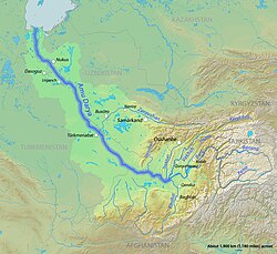
The Zarafshon [2] [a] is a river in Tajikistan and Uzbekistan in Central Asia. Its name, "spreader of gold" in Persian, refers to the presence of gold-bearing sands in the upper reaches of the river. To the ancient Greeks it was known as the Polytimetus. [3] It was also formerly known as Sughd River. The river is 877 kilometres (545 mi) long and has a basin area of 17,700 square kilometres (6,800 sq mi). [4]
It rises at the Zeravshan Glacier, close to where the Turkestan Range and the Zeravshan Range of the Pamir-Alay mountains meet, in Tajikistan. In its upper course, upstream from its confluence with the Fan Darya, it is also called Matcha. [5] It flows due west for some 300 kilometres (190 mi), passing Panjakent before entering Uzbekistan at 39°32′N67°27′E / 39.533°N 67.450°E , where it turns west-to-north-west, flowing past the legendary city of Samarkand, where it feeds the Dargom Canal, which is entirely dependent on the oasis thus created, until it bends left again to the west north of Navoiy and further to the south-west, passing Bukhara before it is lost in the desert beyond the city of Qorakoʻl (Karakul), not quite reaching the Amu Darya, of which it was formerly a tributary.
The Amu Darya ,(Persian: آمو دریا) also shortened to Amu and historically known as the Oxus, is a major river in Central Asia, which flows through Tajikistan, Turkmenistan, Uzbekistan and Afghanistan. Rising in the Pamir Mountains, north of the Hindu Kush, the Amu Darya is formed by the confluence of the Vakhsh and Panj rivers, in the Tigrovaya Balka Nature Reserve on the border between Afghanistan and Tajikistan, and flows from there north-westwards into the southern remnants of the Aral Sea. In its upper course, the river forms part of Afghanistan's northern border with Tajikistan, Uzbekistan, and Turkmenistan. In ancient history, the river was regarded as the boundary of Greater Iran with Turan, which roughly corresponded to present-day Central Asia. The Amu Darya has a flow of about 70 cubic kilometres per year on average.
Tajikistan harkens to the Samanid Empire (819–999). The Tajik people came under Russian rule in the 1860s. The Basmachi revolt broke out in the wake of the Russian Revolution of 1917 and was quelled in the early 1920s during the Russian Civil War. In 1924, Tajikistan became an Autonomous Soviet Socialist Republic of the Soviet Union, the Tajik ASSR, within Uzbekistan. In 1929, Tajikistan was made one of the component republics of the Soviet Union – Tajik Soviet Socialist Republic – and it kept that status until gaining independence 1991 after the dissolution of the Soviet Union.
Tajikistan is nestled between Kyrgyzstan and Uzbekistan to the north and west, China to the east, and Afghanistan to the south. Mountains cover 93 percent of Tajikistan's surface area. The two principal ranges, the Pamir Mountains and the Alay Mountains, give rise to many glacier-fed streams and rivers, which have been used to irrigate farmlands since ancient times. Central Asia's other major mountain range, the Tian Shan, skirts northern Tajikistan. Mountainous terrain separates Tajikistan's two population centers, which are in the lowlands of the southern and northern sections of the country. Especially in areas of intensive agricultural and industrial activity, the Soviet Union's natural resource utilization policies left independent Tajikistan with a legacy of environmental problems.
As of 2007, Uzbekistan's overland transportation infrastructure declined significantly in the post-Soviet era due to low investment and poor maintenance. Air transport was the only branch that received substantial government investment in the early 2000s, as airport modernization projects were undertaken. In the following years, improvements have been made to the surface transport network including the construction of the Tashkent–Samarkand high-speed rail line.
The Syr DaryaSEER-DAR-yə, historically known as the Jaxartes, is a river in Central Asia. The name, which is Persian, literally means Syr Sea or Syr River. It originates in the Tian Shan Mountains in Kyrgyzstan and eastern Uzbekistan and flows for 2,256.25 kilometres (1,401.97 mi) west and north-west through Uzbekistan, Sughd province of Tajikistan, and southern Kazakhstan to the northern remnants of the Aral Sea. It is the northern and eastern of the two main rivers in the endorheic basin of the Aral Sea, the other being the Amu Darya.
Fergana Valley is a valley in Central Asia, lying mostly in eastern Uzbekistan, extending into southern Kyrgyzstan and northern Tajikistan.
The Uzbek Soviet Socialist Republic, also known as Soviet Uzbekistan, the Uzbek SSR, UzSSR, or simply Uzbekistan and rarely Uzbekia or Red Uzbekistan, was a union republic of the Soviet Union. It was governed by the Uzbek branch of the Soviet Communist Party, the legal political party, from 1925 until 1990. From 1990 to 1991, it was a sovereign part of the Soviet Union with its own legislation.
Khujand, sometimes spelled Khodjent and formerly known as Leninabad from 1936 to 1991, is the second-largest city of Tajikistan and the capital of Tajikistan's northernmost Sughd province.
Zarafshon is a city in the center of Uzbekistan's Navoiy Region. Administratively, it is a district-level city, that includes the urban-type settlement Muruntau. It has an area of 20 km2 (7.7 sq mi) and 85,100 inhabitants (2021). Located in the Kyzylkum Desert, it receives water from the Amudarya by a 220-km pipeline.
Russian Turkestan was the western part of Turkestan within the Russian Empire’s Central Asian territories, and was administered as a Krai or Governor-Generalship. It comprised the oasis region to the south of the Kazakh Steppe, but not the protectorates of the Emirate of Bukhara and the Khanate of Khiva. It was populated by speakers of Russian, Uzbek, Kazakh, Kyrgyz, and Tajik.
This article discusses the administrative-territorial division of the Republic of Uzbekistan. The Article 68 of the constitution of Uzbekistan defines:
The Republic of Uzbekistan shall consist of regions, districts, cities, towns, settlements, kishlaks and auls (villages) in Uzbekistan and the Republic of Karakalpakstan.
Navoiy Region is one of the regions of Uzbekistan. It is located in the central north/northwest of the country. It covers an area of 111,095 km2 (42,894 sq mi), which makes it the largest of the regions of Uzbekistan. The Navoiy region borders with Kazakhstan, Samarqand Region, Buxoro Region, Jizzakh Region, and the Karakalpakstan Republic. The population is estimated to be 1,033,857 in 2022, with 51% living in rural areas. The capital is Navoiy. The region and its capital are named after the poet Ali-Shir Nava'i.
The Emirate of Bukhara was a Muslim-Uzbek polity in Central Asia that existed from 1785 to 1920 in what is now Uzbekistan, Tajikistan, Turkmenistan and Kazakhstan. It occupied the land between the Amu Darya and Syr Darya rivers, known formerly as Transoxiana. Its core territory was the fertile land along the lower Zarafshon river, and its urban centres were the ancient cities of Samarqand and the emirate's capital, Bukhara. It was contemporaneous with the Khanate of Khiva to the west, in Khwarazm, and the Khanate of Kokand to the east, in Fergana. In 1920, it ceased to exist with the establishment of the Bukharan People's Soviet Republic.
Sughd Province, also referred to as the Sogdia Region, is one of the four administrative divisions and one of the three provinces that make up Tajikistan. Centered in the historical Sogdiana, it is located in the northwest of the country, with an area of some 25,400 square kilometers and a population of 2,707,300, up from 2,233,550 according to the 2010 census and 1,871,979 in 2000. The capital is Khujand. The Province's ethnic composition in 2010 was 84% Tajik, 14.8% Uzbek, 0.6% Kyrgyz, 0.4% Russian and 0.1% Tatar.
The Yaghnob is a river in Ayni District of Sughd Region, Tajikistan. Together with the Iskander Darya, it forms the Fan Darya, a major left tributary of the Zeravshan.
Jomboy District is a district of Samarqand Region in Uzbekistan. Its capital is Jomboy. It has an area of 550 km2 (210 sq mi) and its population is 176,000.
The Zarafshan Range, formerly the Zeravshan Range, is a mountain range in Tajikistan and Uzbekistan, part of the Pamir-Alay mountains. Almost all of the range belongs to the drainage basins of the Zarafshan River.
Transoxiana or Transoxania is the Latin name for the region and civilization located in lower Central Asia roughly corresponding to modern-day eastern Uzbekistan, western Tajikistan, parts of southern Kazakhstan, parts of Turkmenistan and southern Kyrgyzstan. The name was first coined by Alexander the Great in the 4th century BC when Alexander's troops were able to conquer the region. The region may have had a similar Greek name in the days of Alexander the Great, but the earlier Greek name is no longer known. Geographically, it is the region between the rivers Amu Darya to its south and the Syr Darya to its north.
The Fan Darya is a river located in Ayni District of Sughd Region, Tajikistan. The Fan Darya is 24 kilometres (15 mi) long, and the area of its drainage basin is 3,230 square kilometres (1,250 sq mi). It is a major left tributary of the Zeravshan.
The Central Asian riparian woodlands ecoregion is spread out across the deserts and plains of central Asia between the Aral Sea and the mountains 2,000 kilometres (1,200 mi) to the east. The long narrow components of the ecoregion follow the large rivers fed by snowmelt, and provide critical habitat for migratory birds as they travel through the arid region. The vegetation is referred to as tugai, characterized by low tangles of trees and brush along the edges of the rivers and associated wetlands, and fed by groundwater instead of precipitation.