The Singapore Police Force (SPF) is the national and principal law enforcement agency responsible for the prevention of crime and law enforcement in the Republic of Singapore. It is the country's lead agency against organised crime; human and weapons trafficking; cyber crime; as well as economic crimes that goes across domestic and international borders, but can be tasked to investigate any crime under the purview of the Ministry of Home Affairs (MHA) and is accountable to the Parliament of Singapore.

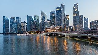
The Singapore River is a river that flows parallel to Alexandra Road and feeds into the Marina Reservoir in the southern part of Singapore. The immediate upper watershed of the Singapore River is known as the Singapore River Planning Area, although the western part of the watershed is classified under the River Valley planning area.
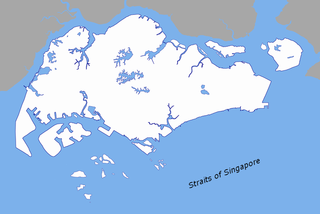
The Singapore Strait is a 113 km-long (70 mi), 19 km-wide (12 mi) strait between the Strait of Malacca in the west and the South China Sea in the east. Singapore is on the north of the channel, and the Indonesian Riau Islands are on the south. The two countries share a maritime border along the strait.

The Armenian Church of Saint Gregory the Illuminator, referred to locally as the Armenian Church, is the oldest Christian church in Singapore, located at Hill Street in the Museum Planning Area, within the Central Area. The church was completed in 1835 and consecrated the next year. Originally a parish of the Armenian Apostolic Church, an Oriental Orthodox denomination, the last Armenian parish priest left in the late 1930s as Armenian population in Singapore dwindled. It was designated as a national monument in 1973. Armenian and Oriental Orthodox services are now regularly held at the church.
Outram Secondary School is a co-educational government secondary school in Singapore. Founded in 1906 as Outram Road School, and later Outram School, it is one of the oldest schools in Singapore. It is also the only government school in Singapore to have a swimming pool.

Sungei Road is a road in Singapore situated between Serangoon Road and Jalan Besar and runs along the Rochor Canal. The area around Sungei Road formerly housed affluent Europeans and Asians, and many ornately designed buildings were built there. Since the 1930s, the road has been synonymous with Sungei Road laksa and the Thieves' Market, the largest and oldest flea market in Singapore, where locals can shop for old bric-a-brac or second-hand goods. The market was permanently closed on 10 July 2017 for "future residential development use".

Scotts Road is a road located in Central Area of Singapore. It was named after Captain William G. Scott, Harbour Master and Post Master of Singapore in 1836, who owned property and plantations on and around the area where Scotts Road now stands.

Fuji Xerox Towers was a high-rise skyscraper located in Downtown Core, Singapore. It was located on 80 Anson Road, in the zone of Shenton Way and Tanjong Pagar. The building sat within four roads, namely Tanjong Pagar Road, Bernam Street, Keppel Road and Anson Road.

Springleaf Tower is a 37-storey, 165 m (541 ft) office and residential skyscraper located in the central business district of Singapore located on 3 Anson Road and near Prince Edward Road, The development is in the zone of Shenton Way and Tanjong Pagar near other skyscrapers, such as 8 Shenton Way, MAS Building, International Plaza, and Anson Centre, all of which are roughly 100 metres away. It is a Grade A office building.

Singapore has had two tramway networks forming part of its public transport arrangements. Both networks were relatively unsuccessful and short lived.

Jurong Town Hall Road is a road in Jurong East, Singapore that connects the Pan Island Expressway and West Coast Road.