River Valley, Singapore

Last updated
River Valley
Other transcription(s)
   Chinese 里峇峇利
   Pinyin Lǐbābālì
   Malay Lembah Sungai
   Tamil நதி பள்ளத்தாக்கு
River Valley Road, Mar 06.JPG
Eateries in pre-war shophouse buildings; these have since been demolished to make way for a new condominium.
River Valley in Central Region, Singapore.svg
Location in Central Region
CountryFlag of Singapore.svg  Singapore
Region Central
Government
  Mayors----
Area
  Total1.48 km2 (0.57 sq mi)
  Rank50th
Population
 (2018)
  Total10,250
  Density6,900/km2 (18,000/sq mi)
Ethnic groups

River Valley is a planning area located within the Central Area of the Central Region of Singapore. The planning area shares boundaries with Orchard in the north, Museum in the east, Tanglin in the west, and Singapore River in the south.

Contents

Etymology

In the 1840s, there were two River Valley roads that ran on either side of the Singapore River. The Singapore River was seen as a valley between Fort Canning Hill, to the north side of the river, and Pearl's Hill, to the south side of the river. The roads on either bank of the Singapore River were named River Valley Road — the current River Valley Road and Havelock Road. Both these River Valley roads were present in John Turnbull Thomson's 1844 map.

History

Singapore River at River Valley facing west Singapore River at River Valley facing west.jpg
Singapore River at River Valley facing west

Adjoining the area around the Singapore River and on high ground, River Valley naturally attracted wealthy Europeans and Chinese merchants who wanted to move away from the crowded town centre and began building their homes in the countryside up river in the 1830s.

Singapore river in River Valley facing North-west Singapore river in River Valley facing North-west.jpg
Singapore river in River Valley facing North-west

One of the first residents to move into the River Valley district was Dr Thomas Oxley, the new colony's surgeon. In 1827, he bought land here from the East India Company and established Killiney Estate as a nutmeg plantation. He had Killiney House built as his residence, named after the hill and village near his Dublin birthplace. [1] The road nearby was named Oxley Road after the surgeon. When the plantation closed, he sold the land in several lots. River Valley Road was once part of Dr Oxley's estate before being divided up in the 1850s. [2]

Singapore river at River Valley. Facing South. Singapore river at River Valley. Facing South.jpg
Singapore river at River Valley. Facing South.

Killiney House was a grand villa built on land behind the eventual site of the Chesed-El Synagogue. This house was subsequently bought by Manasseh Meyer who renamed it Belle Vue and lived in it with his family. It was demolished in 1982.

The Pavilion was another villa built by Thomas Oxley on his estate. When Raffles House was demolished to make way for a fort at Fort Canning in 1859, Government House was moved to the Pavilion. [2] [3] The Pavilion was also the residence of Catchick Moses, the founder of the Straits Times. [4] This house was bought by Manasseh Meyer in 1918. [5]

River Valley was especially popular with the Straits Chinese who also built villas in the area. Among the wealthy who had homes here was Tan Jiak Kim, the grandson of merchant Tan Kim Seng, who built himself a mansion in the 1860s and named it Panglima Prang. He also paid for the construction of the road that came to be named after him — Kim Seng Road.

Another wealthy merchant who lived in the area was Lee Cheng Yan, a Malacca-born Chinese merchant whose mansion built in the 1870s was named Magenta Cottage. The road Cheng Yan Place is named after him.

Most of the big mansions along River Valley have since been demolished. The one surviving villa is the traditional Chinese house built by a wealthy merchant, Tan Yeok Nee, in 1885. This house, House of Tan Yeok Nee, is now a national monument. There is another interesting landmark along River Valley Road known as Nanyang Sacred Union (Chinese :南洋圣教总会), [6] which was established in 1914, is the first Confucian Association in Singapore.

Kal alei, meaning "stone crusher", is the name given by the Tamils to River Valley Road, from the steam crusher which was once kept at the corner of Tank Road and River Valley Road. The Chinese have two other interpretations — ong ke sua kha in Hokkien, meaning "foot of Fort Canning Hill", or leng thau che, meaning "dragon's head well" or "the fountain by the side of the ice works". The latter interpretation could refer to the spring on the hill and the waterfall from it. The ice works belonged to Hoo Ah Kay (c. 1816-1881), which were demolished in 1981.

Features

The residential areas within River Valley consist mainly of private property for high income sections of the population such as The Avenir [7] and Irwell Hill Residences. [8] River Valley is also a popular eating spot for Singaporeans.

Education

Elementary education in the area is provided by the River Valley Primary School.

In media

Related Research Articles

<span class="mw-page-title-main">Katong</span> Neighbourhood in Central Region, Singapore

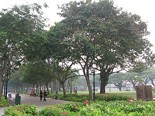
Katong is a residential neighbourhood in the eastern portion of the Central Region of Singapore, within the Marine Parade planning area. Katong district stretches from Fort Road area to Joo Chiat area. It used to be located by the sea, before land reclamation towards the south to East Coast Park was created for housing and recreational purposes beginning in the 1960s to 1970s.

<span class="mw-page-title-main">Orchard Road</span> Planning Area in Central Region, Central Area, Singapore

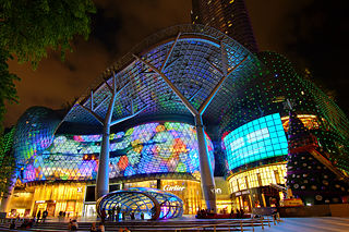
Orchard Road, often known colloquially as simply Orchard, is a major 2.5 km (1.6 mi)-long road in the Central Area of Singapore. A famous tourist attraction, it is an upscale shopping area, with numerous internationally renowned department stores, shopping malls, restaurants, and coffeehouses located in its vicinity.

Aljunied is a sub-urban area located in the central part of the city-state of Singapore. Named after Aljunied Road, it was formerly agricultural land which has since been heavily urbanised and presently comprises a variety of land uses. Today, Aljunied is a bustling neighbourhood with HDB flats with amenities like shops, schools, parks and recreational facilities, as well as quite a number of traditional Singaporean shophouses.

<span class="mw-page-title-main">Tanjong Pagar</span> Historic district in Singapore

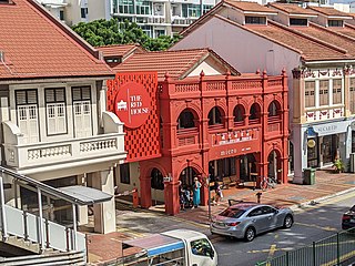
Tanjong Pagar is a historic district located within the Central Business District of Singapore, straddling the Outram Planning Area and the Downtown Core under the Urban Redevelopment Authority's urban planning zones. The district has a rich history and is known for its cultural and architectural landmarks, making it a popular tourist destination.

<span class="mw-page-title-main">House of Tan Yeok Nee</span> Singaporean mansion building

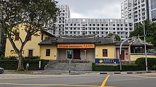
The House of Tan Yeok Nee is a mansion building located at the junction of Penang Road and Clemenceau Avenue in the Museum Planning Area in Singapore. After an extensive restoration completed in 2000, it was held by the University of Chicago Booth School of Business. As of 2019, the building serves as the Singapore campus for Amity Global Institute.

<span class="mw-page-title-main">George Drumgoole Coleman</span> Irish-Singaporean architect (1795 – 1844)

George Drumgoole Coleman, also known as George Drumgold Coleman, was an Irish civil architect who played an instrumental role in the design and construction of much of the civil infrastructure in early Singapore, after it was founded by Sir Stamford Raffles in 1819. Only a few of his buildings have survived in Singapore, most notably Armenian Church of Saint Gregory the Illuminator, Maxwell's House, and Caldwell House.

<span class="mw-page-title-main">Hill Street, Singapore</span>

Hill Street is a major road in the Downtown Core of Singapore, starting from Eu Tong Sen Street and ending at Stamford Road, where the road becomes Victoria Street. The road starts after Coleman Bridge and at the junction of River Valley Road, North Boat Quay, Eu Tong Sen Street and New Bridge Road.

<span class="mw-page-title-main">Tan Kim Seng</span>

Tan Kim Seng, was a prominent Straits-born Chinese merchant and philanthropist in Singapore in the 19th century.

<span class="mw-page-title-main">Emerald Hill, Singapore</span>

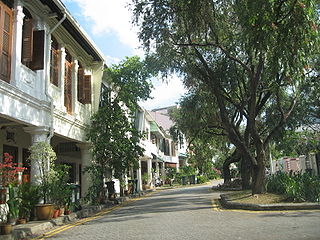
Emerald Hill is a neighbourhood and a conservation area located in the planning areas of Newton and Orchard in Singapore. Former home to many members of the city-state's wealthy Peranakan community, it is located near Orchard Road. Many of its homes feature Chinese Baroque architecture. Emerald Hill also the setting for some of the short stories by the late Singaporean author Goh Sin Tub. Many of the homes were designed by Mr R T Rajoo an architect/contractor of those days who died in 1929 at his home in Tank Road, Singapore.

<span class="mw-page-title-main">New Bridge Road</span> Road in Singapore

New Bridge Road is a major one-way road located within the Central Area in Singapore.

<span class="mw-page-title-main">Keong Saik Road</span>

Keong Saik Road is a one-way road located in Chinatown within the Outram Planning Area in Singapore. The road links New Bridge Road to Neil Road, and is intersected by Kreta Ayer Road.

<span class="mw-page-title-main">Ann Siang Hill</span> Street in Singapore

Ann Siang Hill is a small hill, and the name of a one-way road located in Chinatown, Singapore. It was named after Chia Ann Siang, a wealthy businessman. The road links Club Street and Ann Siang Road (安祥路) to South Bridge Road.

<span class="mw-page-title-main">Duxton Hill</span>

Duxton Hill is a small hill, as well as the name of a road, located in Tanjong Pagar in the Downtown Core district of Singapore.

<span class="mw-page-title-main">Esplanade Park</span>

Esplanade Park is a park located at the Esplanade area within the Downtown Core district of Singapore.

<span class="mw-page-title-main">Stamford Road</span>

Stamford Road is a one-way road in Singapore within the planning areas of Downtown Core and Museum. The road continues after the traffic light junction of Nicoll Highway, Esplanade Drive and Raffles Avenue towards Orchard Road. It then ends at the junction of Fort Canning Road, Bencoolen Street and Orchard Road, which it continues to be Orchard Road. Stamford Road is home to several landmarks, including Swissôtel The Stamford and the National Museum of Singapore.

<span class="mw-page-title-main">Ord Bridge</span>

Ord Bridge is a pedestrian bridge in Singapore. It spans the Singapore River at Clarke Quay, located in the Singapore River Planning Area within the Central Area.

<span class="mw-page-title-main">Tan Kim Seng Fountain</span>

The Tan Kim Seng Fountain is a fountain in Singapore that was erected in 1882 in honor of notable philanthropist Tan Kim Seng for his donations for the Singapore's first reservoir and waterworks.

<span class="mw-page-title-main">Raffles House</span> Bungalow in Singapore, Singapore

Raffles House is a single-storey building built on the Fort Canning Hill, Singapore. The original building was a wood and atap structure built in 1822 that was used as a place of residence by Sir Stamford Raffles. This building was later rebuilt as a neoclassical-styled Government House as the residence of subsequent colonial governors, but it was demolished in 1858 to make way for the construction Fort Canning. The present structure built on the same site is a brick and tile building constructed in 2003.

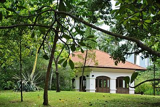
The Pavilion is a house located at 5 Oxley Rise, Oxley Hill, near Orchard Road in Singapore. The Pavilion served as Government House between 1859 and 1861, after Raffles House was demolished to make way for a fort.

<span class="mw-page-title-main">Tank Road railway station</span> Former train terminus in Singapore

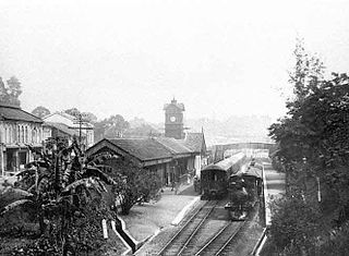
Tank Road railway station was a railway station which served as a terminus on the Singapore-Kranji Railway from 1903 to 1932.

References

  1. Savage, Victor R.; Yeoh, Brenda (2013-06-15). Singapore Street Names: A Study of Toponymics. Marshall Cavendish International Asia Pte. ISBN   9789814484749.
  2. 1 2 "River Valley". Singapore Infopedia. National Library Board.
  3. "The Singapore Free Press". The Singapore Free Press and Mercantile Advertiser. 26 May 1859.
  4. "Late Mr. M. Catchick Moses". The Straits Times. 20 July 1920.
  5. "Property Sale". Malaya Tribune. 9 October 1918.
  6. "Nanyang Sacred Union". Roots.gov.sg. Retrieved 31 August 2023.
  7. "The Avenir Condo @ River Valley By Guocoland & Hong Leong". The Avenir Condo. Retrieved 2021-03-20.
  8. "Irwell Hill Residences at Irwell Bank Road in River Valley". Irwell Hill Residences at Irwell Bank Road in River Valley. Retrieved 2021-03-20.
  9. Savage, Victor R.; Yeoh, Brenda (2013-06-15). Singapore Street Names: A Study of Toponymics. Marshall Cavendish International Asia Pte Ltd. ISBN   978-981-4484-74-9.
  10. Lee, Geok Boi (2002). The Religious Monuments of Singapore: Faiths of Our Forefathers. Preservation of Monuments Board. ISBN   978-981-3065-62-8.