List of places in Singapore

Last updated

This is a list of places in Singapore based on the planning areas and their constituent subzones as designated by the Urban Redevelopment Authority (URA).

Contents

Based on the latest URA Master Plan in 2019, the country is divided into 5 regions, which are further subdivided into 55 planning areas, and finally subdivided into a total of 332 subzones. [1]

Both planning areas and subzones are listed below in alphabetical order. Population data is accurate as of June 2018, [2] which does not necessarily reflect the same boundaries as in the 2019 Master Plan. Additionally, the figures include citizens and permanent residents but do not include the approximately 1.6 million non-permanent residents of Singapore.

Central Region

The Central Region of Singapore is made up of 22 planning areas, of which 10 form the Central Area. The region comprises 135 subzones in total. Planning areas that are part of the Central Area are italicised.

Planning Area [1] Subzone [1] Estimated population (2018) [2] Remarks
Bishan Bishan East 28,750
Marymount 30,250
Upper Thomson 29,490
Bukit Merah Alexandra Hill 14,240
Alexandra North 1,410
Bukit Ho Swee 15,150
Bukit Merah 1,130
City Terminals30Formerly called Tanjong Pagar.
Depot Road 6,390
Everton Park 8,420
Henderson Hill 11,510
Kampong Tiong Bahru 9,470
Maritime Square 3,200Formerly called HarbourFront.
Redhill12,100
Singapore General Hospital 10
Telok Blangah Drive17,940
Telok Blangah Rise12,650
Telok Blangah Way9,790
Tiong Bahru 12,800
Tiong Bahru Station15,660
Bukit Timah Anak Bukit22,090
Coronation Road6,390
Farrer Court6,240
Hillcrest9,120
Holland Road 10,630
Leedon Park6,460
Swiss Club5,620
Ulu Pandan10,730
Downtown Core Anson 80
Bayfront Subzone 0
Bugis 840
Cecil220
Central Subzone630
City Hall 60
Clifford Pier 0
Marina Centre 10
Maxwell0
Nicoll-Added in 2019.
Phillip0
Raffles Place 60
Tanjong Pagar 600
Geylang Aljunied 39,990
Geylang East 31,180
Kallang Way50
Kampong Ubi 12,340
MacPherson 28,050
Kallang Bendemeer 35,980
Boon Keng 12,230
Crawford 8,960
Geylang Bahru 11,950
Kallang Bahru 20
Kampong Bugis 820
Kampong Java 10,710
Lavender 9,710
Tanjong Rhu 11,060
Marina East Marina East 0
Marina South Marina South 0
Marine Parade East Coast 0
Katong 9,380
Marina East0
Marine Parade27,550
Mountbatten 10,330
Museum Bras Basah 10
Dhoby Ghaut 240
Fort Canning 170
Newton Cairnhill3,690
Goodwood Park 1,140
Istana Negara 40
Monk's Hill970
Newton Circus220
Orange Grove1,580
Novena Balestier 32,370
Dunearn3,880
Malcolm2,810
Moulmein9,190
Mount Pleasant700
Orchard Boulevard430
Somerset140
Tanglin430
Outram China Square1,460
Chinatown 10,930
Pearl's Hill 7,340
People's Park300
Queenstown Commonwealth 7,420
Dover 11,290
Ghim Moh 13,550
Holland Drive 13,170
Kent Ridge 840
Margaret Drive15,000
Mei Chin15,810
National University of Singapore 230
one-north 650
Pasir Panjang 14,370
Pasir Panjang 23,290
Port 110
Queensway290
Singapore Polytechnic 110
Tanglin Halt11,750
River Valley Institution Hill3,500
Leonie Hill2,830
One Tree Hill1,920
Oxley1,460
Paterson220
Rochor Bencoolen 1,280
Farrer Park 2,830
Kampong Glam 160
Little India 3,460
Mackenzie130
Mount Emily 1,330
Rochor Canal 0
Selegie220
Sungei Road 2,140
Victoria 1,910
Singapore River Boat Quay 130
Clarke Quay 140
Robertson Quay 2,710
Southern Islands Sentosa 1,800
Southern Group0
Straits View Straits View 0
Tanglin Chatsworth6,490
Nassim9,440
Ridout1,390
Tyersall 3,650
Toa Payoh Bidadari 0
Boon Teck13,600
Braddell10,040
Joo Seng 7,980Formerly called Paya Lebar.
Kim Keat8,290
Lorong 8 Toa Payoh7,510Formerly called Kallang.
Pei Chun10,790
Potong Pasir 11,310
Sennett5,410
Toa Payoh Central28,860
Toa Payoh West14,290Formerly called Marymount.
Woodleigh2,420
Total926,040

East Region

The East Region of Singapore consists of 6 planning areas, comprising 30 subzones in total. Tampines serves as the regional centre of the East Region.

Planning Area [1] Subzone [1] Estimated population (2018) [2] Remarks
Bedok Bayshore7,240
Bedok North82,620
Bedok Reservoir 25,830
Bedok South48,010
Frankel34,030
Kaki Bukit 38,470
Kembangan 38,530
Siglap 6,570
Changi Changi Airport 0
Changi Point 590
Changi West1,480
Changi Bay Changi Bay 0
Pasir Ris Flora Drive14,650
Loyang East2,150
Loyang West180
Pasir Ris Central30,520Formerly called Town.
Pasir Ris Drive55,970
Pasir Ris Park 7,280
Pasir Ris Wafer Fab Park20Formerly called Pasir Ris West.
Pasir Ris West36,140Formerly called Elias.
Paya Lebar Airport Road0
Paya Lebar East10
Paya Lebar North20
Paya Lebar West0
PLAB 0
Tampines Simei 40,330
Tampines East135,070
Tampines North0
Tampines West79,980
Xilin1,730
Total687,420

North Region

The North Region of Singapore is made up of 8 planning areas, comprising 41 subzones in total. Its regional centre is located at Woodlands.

Planning Area [1] Subzone [1] Estimated population (2018) [2] Remarks
Central Water Catchment Central Water Catchment 0
Lim Chu Kang Lim Chu Kang 110
Mandai Mandai East0
Mandai Estate2,090
Mandai West0
Sembawang Admiralty 14,160
Sembawang Central30,550
Sembawang East8,490
Sembawang North26,200
Sembawang Springs6,210
Sembawang Straits1,720
Senoko North20
Senoko South20
The Wharves 0
Simpang Pulau Seletar 0
Simpang North0
Simpang South0
Tanjong Irau0
Sungei Kadut Gali Batu30Formerly called Mandai.
Kranji 10
Pang Sua20
Reservoir View20
Turf Club 690
Woodlands Greenwood Park50
Midview35,960
North Coast12,900
Senoko West20
Woodgrove34,590
Woodlands East97,090
Woodlands Regional Centre10
Woodlands South41,150
Woodlands West 30,770
Yishun Khatib10,540
Lower Seletar 15,280
Nee Soon890
Northland29,070
Springleaf4,230
Yishun Central1,350
Yishun East56,940
Yishun South40,870
Yishun West 55,770
Total557,820

North-East Region

The North-East Region of Singapore is made up of 7 planning areas, comprising 48 subzones in total. There are plans to transform Seletar into the regional centre of the North-East Region in the future.

Planning Area [1] Subzone [1] Estimated population (2018) [2] Remarks
Ang Mo Kio Ang Mo Kio Town Centre4,820
Cheng San 28,320
Chong Boon 27,080
Kebun Bahru 22,970
Sembawang Hills6,760
Shangri-La16,560
Tagore8,110Formerly called Sindo.
Townsville21,900
Yio Chu Kang 50
Yio Chu Kang East4,180
Yio Chu Kang North0Formerly called Seletar.
Yio Chu Kang West24,960
Hougang Defu Industrial Park 20
Hougang Central4,730
Hougang East25,020
Hougang West46,300
Kangkar30,300
Kovan 25,730Formerly called Rosyth.
Lorong Ah Soo32,480
Lorong Halus 0Formerly called Sungei Serangoon.
Tai Seng14,190Formerly called Tai Keng.
Trafalgar 44,240
North-Eastern Islands North-Eastern Islands 50
Punggol Coney Island 0
Matilda 47,930
Northshore270
Punggol Canal0
Punggol Field48,380
Punggol Town Centre17,490
Waterway East47,500
Seletar Pulau Punggol Barat0
Pulau Punggol Timor0
Seletar230
Seletar Aerospace Park 20
Sengkang Anchorvale 43,740Formerly called Buangkok.
Compassvale 21,160Formerly called Trafalgar.
Fernvale 53,810Formerly called Jalan Kayu East.
Lorong Halus North0Formerly called Sungei Serangoon East.
Rivervale 60,660Formerly called Sungei Serangoon West.
Sengkang Town Centre61,270
Sengkang West10Formerly called Jalan Kayu West.
Serangoon Lorong Chuan 8,520
Seletar Hills13,920
Serangoon Central25,160
Serangoon Garden 37,260
Serangoon North 16,240
Serangoon North Industrial Estate10
Upper Paya Lebar16,200
Total908,550

West Region

The West Region of Singapore consists of 12 planning areas, comprising 78 subzones in total. The regional centre of the West Region is Jurong East.

Planning Area [1] Subzone [1] Estimated population (2018) [2] Remarks
Boon Lay Liu Fang10
Samulun 10
Shipyard10
Tukang10
Bukit Batok Brickworks 5,080
Bukit Batok Central 26,630
Bukit Batok East13,280
Bukit Batok West15,030
Bukit Batok South15,440
Gombak 10,080
Guilin 13,110
Hillview 18,980
Hong Kah North26,800
Bukit Panjang Bangkit22,920
Dairy Farm 6,730
Fajar28,490
Jelebu31,940
Nature Reserve 3,790
Saujana26,310
Senja 20,650
Choa Chu Kang Choa Chu Kang Central21,500
Choa Chu Kang North32,900Formerly called Kranji North and Pang Sua.
Keat Hong32,750
Peng Siang33,690
Teck Whye25,260
Yew Tee 41,420
Clementi Clementi Central13,840
Clementi North29,510
Clementi West15,810
Clementi Woods 15,750
Faber5,880
Pandan10
Sunset Way6,020
Toh Tuck 20
West Coast 6,170
Jurong East International Business Park 10
Jurong Gateway430Formerly called Regional Centre.
Jurong Port 0
Jurong River 10
Lakeside (Business)870 [note 1]
Lakeside (Leisure)
Penjuru Crescent 10
Teban Gardens 19,270
Toh Guan15,200
Yuhua East25,460
Yuhua West19,920Formerly called Boon Lay.
Jurong West Boon Lay Place 30,200
Chin Bee 10
Hong Kah 54,880
Jurong West Central 65,720
Kian Teck 50
Safti 0
Taman Jurong 38,660
Wenya 8,360
Yunnan 68,840
Pioneer Benoi Sector 10
Gul Basin20
Gul Circle 30
Joo Koon 30
Pioneer Sector 0
Tengah Brickland10 [note 2]
Forest Hill
Garden
Park
Plantation
Tengah Industrial Estate
Tuas Tengeh0
Tuas Bay10
Tuas North40Formerly called Pioneer.
Tuas Promenade0
Tuas View 20
Tuas View Extension10Formerly called Coast.
Western Islands Jurong Island and Bukom 10
Semakau 0
Sudong 0
Western Water Catchment Bahar720 [note 3]
Cleantech
Murai
Total914,640

Notes

  1. Lakeside (Business) and Lakeside (Leisure) was a single subzone as of 2018.
  2. Separate subzones for Tengah planning area did not exist in 2018.
  3. Separate subzones for Western Water Catchment planning area did not exist in 2018.

See also

Related Research Articles

<span class="mw-page-title-main">Ang Mo Kio</span> Planning Area and HDB Town in Singapore

Ang Mo Kio is a planning area and residential town situated in the North-East of Singapore. Located approximately 11 km (6.8 mi) north of the Downtown Core district, Ang Mo Kio is the 3rd most populated planning area in the North-East Region and ranks 8th in terms of population in the country overall. The planning area is located at the south-western corner of the North-East Region, bordered by the planning areas of Yishun to the north, Sengkang to the north-east, Serangoon to the east, Bishan to the south and the Central Water Catchment to the west.

<span class="mw-page-title-main">Pasir Ris</span> Planning Area and HDB Town in East Region ----, Singapore

Pasir Ris is a planning area and residential town located in the East Region of Singapore. It is bordered by Tampines and Paya Lebar to the south, Sengkang to the southwest and Changi to the east. The planning area also shares riverine boundary with Punggol to the west, separated by the Serangoon River, as well as having a maritime boundary with the North-Eastern Islands planning area, across the Straits of Johor.

<span class="mw-page-title-main">Kallang</span> Planning Area and HDB Town in Central Region ----, Singapore

Kallang is a planning area and residential zone located in the Central Region of Singapore.

<span class="mw-page-title-main">Bedok</span> Planning Area and HDB Town in East Region ----, Singapore

Bedok is a planning area and residential town located in the geographical region of Tanah Merah along the south-eastern coast of the East Region of Singapore. Bedok is bounded by five other planning areas: Paya Lebar to the north, Hougang to the northwest, Tampines to the northeast and east, Geylang to the west and Marine Parade to the southwest. It also shares a maritime boundary with the Singapore Strait to the south and southeast.

<span class="mw-page-title-main">Seletar</span> Planning Area and Regional Centre in North-East Region ----, Singapore

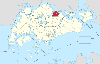
Seletar is an area located in the north-east of Singapore. Its name can also refer to the Seletar Planning Area, situated in the North-East Region of Singapore. The place name was derived from the Malay subgroup who were indigenous to the area, the Orang Seletar. It shares boundaries with the planning areas of Sengkang to the south, Punggol to the east, Yishun and Simpang to the west, as well as the Straits of Johor to the north.

<span class="mw-page-title-main">Jurong East</span> Planning Area and Regional Centre in West Region, Singapore

Jurong East is a planning area and residential town situated in the West Region of Singapore. It borders Jurong West and Boon Lay to the west, Clementi to the east, Tengah and Bukit Batok to the north and Selat Jurong to the south.

<span class="mw-page-title-main">Boon Lay</span> Place in Singapore

Boon Lay is a neighbourhood located in the town of Jurong West in the West Region of Singapore. Its borders very roughly correspond to the URA subzone of Boon Lay Place, situated within the Jurong West Planning Area.

<span class="mw-page-title-main">Jurong West</span> Residential town in the West Region of Singapore

Jurong West is a planning area and residential town located in the West Region of Singapore. Jurong West shares boundaries with Tengah in the north, Jurong East in the east, Boon Lay and Pioneer in the south, and Western Water Catchment in the west.

<span class="mw-page-title-main">North Region, Singapore</span> Region in Singapore

The North Region of Singapore is one of the five regions in the city-state. The region is the second largest region in terms of land area, and has a population of 582,330. Woodlands is the regional centre and also the most populous town with 255,130 residents living in the area. Comprising 13,500 hectares of land area, it includes eight planning areas.

<span class="mw-page-title-main">Planning Areas of Singapore</span> Main urban planning and census divisions of Singapore

Planning areas, also known as DGP areas or DGP zones, are the main urban planning and census divisions of Singapore delineated by the Urban Redevelopment Authority. There are a total of 55 of these areas, organised into five regions. A Development Guide Plan is then drawn up for each planning area, providing for detailed planning guidelines for every individual plot of land throughout the country.

Urban planning in Singapore is the direction of infrastructure development in Singapore. It is done through a three-tiered planning framework, consisting of a long-term plan to plot out Singapore's development over at least 50 years, a Master Plan for the medium term, and short-term plans, the first two of which are prepared by the Urban Redevelopment Authority (URA) and the last by multiple agencies.

<span class="mw-page-title-main">Regions of Singapore</span> Subdivisions in the country of Singapore

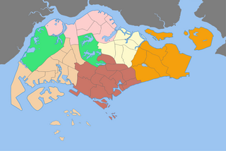
The regions of Singapore are urban planning subdivisions demarcated by the Urban Redevelopment Authority of Singapore to aid in its planning efforts. Over time, other governmental organisations have also adopted the five regions in their administrative work, as for example the Department of Statistics in the census of 2000. The regions are further subdivided into 55 planning areas, which include two water-catchment areas. The largest region in terms of area is the West Region with 201.3 km2 (77.7 sq mi), while the Central Region is the most populous with an estimated population of 922,980 inhabitants in the area in 2019.

<span class="mw-page-title-main">West Region, Singapore</span> Region in Singapore

The West Region of Singapore is one of the five regions in the city-state. The region is the largest in terms of land area and is the third most populous region after the North-East Region and Central Region. Jurong East is the regional centre of the region, with plans of developing the Jurong Lake District into a second CBD area. Jurong West is the most populous town in the region, with a population of 262,730 residents. Comprising 25,500 hectares of land area, it includes twelve planning areas and is home to about 922,540 residents.

<span class="mw-page-title-main">North-East Region, Singapore</span> Region in Singapore

The North-East Region of Singapore is one of the five regions in the country. The region is the most densely populated and has the highest population among the five, with Sengkang being its most populous town as of 2020 and Seletar as the regional centre. Comprising 13,810 hectares, it includes seven planning areas and is largely a residential region with 217,120 homes. Housing largely consists of high-density HDB public housing estates, however private housing is also present in the region. As its name implies, it is located in the north-eastern part of Singapore.

<span class="mw-page-title-main">Jurong Lake District</span>

Jurong Lake District is a district of Singapore, planned as part of Urban Redevelopment Authority (URA)’s decentralisation efforts to bring more quality jobs, amenities, and recreational options closer to homes. The plans for the district have continued to evolve since the blueprint was first unveiled in the URA Master Plan 2008. It consists of three precincts, namely Jurong Gateway, Lakeside and Lakeside Gateway. It is 472 hectares (4,720,000 m2) in size and served by two major expressways and three MRT stations. It will be the Singapore's next central business district. In June 2023, a white site 6.5 hectares (ha) in size was released for sale to kick-start development of the largest commercial district outside Singapore’s city centre.

Wenya is a subzone of Jurong West, Singapore.

<span class="mw-page-title-main">Lavender, Singapore</span> Subzone of Kallang Planning Area in Central Region, Singapore

Lavender is a subzone within the planning area of Kallang, Singapore, as defined by the Urban Redevelopment Authority (URA). Lavender is composed of an area bounded by Tessensohn Road in the north; Balestier Road, Lavender Street and Crawford Street in the east; the Rochor River and Rochor Canal in the south; as well as Syed Alwi Road, Serangoon Road and Rangoon Road in the west.

Yuhua is a subzone region located in the town of Jurong East, Singapore. Yuhua comprises two subzones, Yuhua East and Yuhua West. The area's HDB flats are under the management of Jurong-Clementi Town Council and the people of this precinct are represented in parliament by either Grace Fu or Rahayu Mahzam, depending on where they stay.

<span class="mw-page-title-main">Kampong Java</span> Subzone of Kallang Planning Area in Central Region, Singapore

Kampong Java is a subzone within the planning area of Kallang, Singapore, as defined by the Urban Redevelopment Authority (URA). It is bounded by the Central Expressway (CTE) in the west; Balestier Road in the north; Tessensohn Road, Race Course Road, Gloucester Road, Northumberland Road and Tekka Lane in the east; and Bukit Timah Road in the south.

<span class="mw-page-title-main">Straits View</span> Planning Area in Central ----, Singapore

Straits View is a planning area located in the Central Area of the Central Region of Singapore. The area is currently relatively undeveloped, with fewer commercial developments compared to the adjacent Downtown Core.

References

  1. 1 2 3 4 5 6 7 8 9 10 11 "Master Plan 2019 Subzone Boundary (No Sea) — Data.gov.sg". beta.data.gov.sg. Retrieved 12 December 2023.
  2. 1 2 3 4 5 6 "Singapore Residents by Subzone and Type of Dwelling, Jun 2018 — Data.gov.sg". beta.data.gov.sg. Retrieved 12 December 2023.

Further reading