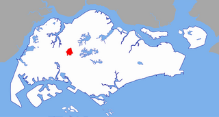
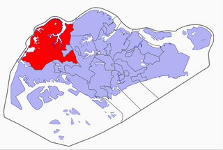
Bukit Batok, often abbreviated as Bt Batok, is a planning area and matured residential town located along the eastern boundary of the West Region of Singapore. Bukit Batok statistically ranks in as the 25th largest, the 12th most populous and the 11th most densely populated planning area in Singapore.[3][5] It is bordered by six other planning areas - Choa Chu Kang to the North, Northeast and Northwest, Cashew to the northeast and East, Clementi to the South, Bukit Timah to the southeast, Jurong East to the southwest and Tengah to the west.[6][7]
Bukit Batok largely sits on Gombak norite, a geological formation that is found in high concentrations within the planning area itself, as well as in the western parts of neighbouring Cashew.[8][9][10] It was this presence of the igneous rock that made Bukit Batok a pivotal location for the quarrying industry in Singapore around the turn of the mid-20th century.[11]
Etymology
Many differing accounts describe the origin of the name Bukit Batok. Bukit means "hill" in Malay, thus the name of the town gives the impression of it being hilly. Batok, however, has several interpretations.
One version, according to a Javanese village chief of the village Gassing, that coconut trees grew in the hilly area and hence the area was named batok, the Javanese term for coconuts.[12]
The Chinese version is that the hills of solid granite, which is called batu in Malay, and then subsequently misnamed as bato and then finally batok.[12] Another version was that hill looks like a human skull top and the words skull top was pronounced as batok.[12]
Others believe that batok, the Malay word for cough, is linked to the place either because of its cool air (causing coughs and colds),[12] or due to the sound of explosives historically used at its granite quarry, Little Guilin.
History
Before 1940s, Bukit Batok was heavily dominated by rubber and pineapple plantations. At the start of the 1940s, industrialization began to gradually occur in Bukit Timah. Ford factory was one of the first factories to be built along Bukit Timah road near the current day's site.
Consequently, the British's plans to industrialize Bukit Timah was short-lived and put to an abrupt halt during World War II. The factories that were built before 1942 were swiftly taken over by the Japanese during their occupation of Singapore. Ford Factory, which sits at the bottom of the Bukit Batok Hill, was occupied by Nissan, the Japanese Multination Corporation, to supply military vehicles for the Imperial Japanese Army Force. Both Bukit Batok hill (current day Bukit Batok Nature Park) and Bukit Timah hill were considered as strategic hill grounds (Figure 6) during the Japanese Occupation. These locations were key to controlling the surrounding areas and thus were the site of the fiercest battles of the war.
Following the successful conquest of Singapore, General Yamashita ordered 500 Australian prisoners of war to construct a Japanese war memorial, Syonan Chureito shrine, at the top of Bukit Batok Hill. Throughout the Japanese Occupation, the Japanese officials and military personnel would frequently worship their emperor in the Syonan Chureito shrine. In addition, footages of these ceremonies would be broadcast as propaganda in Japan to ensure the citizens’ continuous support for the war. However, the shrine was ultimately destroyed by the Japanese themselves at the end of the World War II as they feared that the honour of the memorial would be tarnished by the returning British troops.
After World War II, the British returned to Singapore. The areas around Ford Factory became known as the British's ‘colonial estate factories’ as the British resumed their plans to industrialize Bukit Batok. In addition to the development of factories, Bukit Batok began to be extensively quarried for granite.[14] The Poh Kim Quarry, which lies in the heart of Bukit Batok Nature Park today, was one of the quarry sites in the vicinity. It was quarried for granite between the 1950s to the 1970s but was later abandoned due to the damage that the activities was causing to the Earth's core.
After Singapore gained independence in 1965, the newly formed People's Action Party (PAP) government aggressively promoted the site as a lightweight industrial area.
Development of Bukit Batok New Town began in December 1975,[1] transforming the former village into a new town in the rough span of a decade.[11] As a testament to its heritage, several norite formations and ridges remained preserved, most of which can be found at both Bukit Batok Nature Park and Bukit Batok Town Park as a characteristic feature of the modern-day town.[15][16]
Geography
Location
Bukit Batok Planning Area is bordered by six other planning areas - Choa Chu Kang to the north and northwest, Bukit Panjang to the northeast and east, Clementi to the south, Bukit Timah to the southeast, Jurong East to the southwest and Tengah to the west.
Bukit Batok New Town is located within Bukit Batok Planning Area.
Subzones
Bukit Batok Planning Area is divided into 9 subzones:
Areas bounded by Bukit Batok East Avenue 2, Bukit Batok East Avenue 3, Bukit Batok East Avenue 4, Bukit Batok East Avenue 5 and Bukit Batok East Avenue 6
Bukit Batok East Community Club and Bukit Batok Neighbourhood Police Centre, Hock Thong Temple, See Thian Foh Temple and Masjid Ar-Raudhah Mosque
Buses
Bukit Batok South
Areas bounded by Bukit Batok East Avenue 1, 3 and 6; the Pan-Island Expressway, Toh Tuck Road and the western side of the landed houses along Jalan Jurong Kechil.
Areas bounded by Bukit Batok Road, West Avenue 3/6, Avenue 1 and the Pan-Island Expressway.
Bukit Batok Secondary School, Princess Elizabeth Primary School, Guilin Combined Temple, Sattha Puchaniyaram Buddhist Temple and Bukit Batok Providence Presbyterian Church
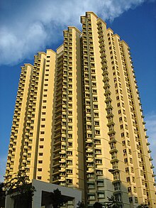
A block of HDB flats along Bukit Batok West Avenue 5
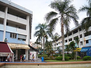
Bukit Batok's main shopping complex West Mall was opened in mid-1998. Developed by Alprop Pte. Ltd., a joint venture between the United Industrial Corporation (UIC) and Singapore Land, it has 7 storeys in total gross floor area of 283,000sqft(26,300m2) on a land area of 106,000sqft(9,800m2). It was built at a cost of S$170 million and houses amenities including a post office, Community Library and Cineplex, together with shops, restaurants and a supermarket.
The Bukit Batok Bus Interchange, sited near to Bukit Batok MRT station and West Mall, is of moderate size and nearly completely used by Tower Transit Singapore. The interchange and most of the services were previously operated by Singapore Bus Services (the precursor of SBS Transit), until 26 December 2000, when bus services were transferred to Trans-Island Bus Services (the precursor of SMRT Buses). SMRT Buses remained the operator until 29 May 2016, when only bus services 852 (until 2018, under Seletar Bus Package) and 61 and 991 were left with SMRT Buses. SBS Transit still has a bus depot in Bukit Batok.
Public service and utility
Bukit Batok has 1 fire station located at 80 Bukit Batok Rd, Singapore 658072.[17] The HDB Branch is located at Bukit Batok Central.[18]
Education
As of 2023[update], this area has a total of six primary schools and five secondary schools.[19] These include Princess Elizabeth Primary School, Keming Primary School, Lianhua Primary School, St. Anthony's Primary School, Bukit View Primary School, Bukit View Secondary School, Bukit Batok Secondary School, Hillgrove Secondary School, Dunearn Secondary School. Yusof Ishak Secondary School relocated from Bukit Batok to its Punggol campus in 2022.[20]
The CDANS Bukit Batok Country Club, for reservist members of the Civil Defence forces and their families, was opened in 1998. It offers a golf driving range, swimming pool, bowling alley and sports facilities for relatively affordable prices.
The Civil Service Club Bukit Batok Clubhouse offers swimming, bowling and related recreational facilities to civil servants, their families and the public. It is located near Bukit Batok Town Centre and was opened on 1 March 2006.
Politics
The jurisdiction of Bukit Batok is shared by the Jurong Group Representation Constituency (Jurong GRC), which has an office at Bukit Batok Central and manages much of Bukit Batok; and Chua Chu Kang Group Representation Constituency (Chua Chu Kang GRC), which manages areas north of Bukit Batok West Avenue 3 and Bukit Batok Central. There are four members of Parliament, two from each GRC, representing various areas in Bukit Batok.
Bukit Batok was a single-member constituency by itself prior to the 1991 elections, which was later mainly consolidated into Jurong GRC until in the 2015 elections, where it carved out as a SMC again. As of 2016, Bukit Batok represents in Jurong GRC and Bukit Batok SMC. For Jurong GRC, Bukit Batok East is the only constituency, of which Rahayu Mahzam is the current MP. David Ong, served as an MP for Bukit Batok constituency until his sudden resignation in March 2016; Murali Pillai, a candidate who contested and lost Aljunied GRC in the 2015 elections, has since represented Bukit Batok, following his by-election victory in May 2016.
In the same elections in 2011 and 2015, Bukit Gombak represents in Chua Chu Kang GRC, there are two constituencies also in Bukit Gombak, one of which it is a different system. Bukit Gombak represents as Low Yen Ling MP, while Amy Khor represented Hong Kah North SMC.
Related Research Articles
Jurong is a major geographical region located at the south-westernmost point of the West Region of Singapore. Although mostly vaguely defined, the region's extent roughly covers the planning areas of Jurong East, Jurong West, Boon Lay, and Pioneer, along with Jurong Island in the Western Islands cluster and the southernmost portions of the Western Water Catchment. Should it be described at its greatest historical extent, the region can also include present-day Bukit Batok and Tuas.
Clementi is a planning area and residential town located at the easternmost fringe of the West Region of Singapore. The town borders Bukit Batok to the north, Bukit Timah to the northeast, Queenstown to the east and Jurong East to the west.
Choa Chu Kang, alternatively spelled Chua Chu Kang and often abbreviated as CCK, is a planning area and residential town located at the northwestern point of the West Region of Singapore. The town shares borders with Sungei Kadut to the north, Tengah to the southwest, Bukit Batok to the southeast, Bukit Panjang to the east and the Western Water Catchment to the west. Choa Chu Kang New Town is separated into two portions by the Kranji Expressway.
Bukit Panjang is a planning area and residential town located in the West Region of Singapore. A portion of this town is situated on a low-lying elongated hill. The planning area is bounded by Bukit Batok to the west, Choa Chu Kang to the northwest, Sungei Kadut to the north, the Central Water Catchment to the east and Bukit Timah to the south. Bukit Panjang New Town is located at the northern portion of the planning area. Bukit Panjang has an average elevation of 36m/118 ft.
Jurong East is a planning area and residential town situated in the West Region of Singapore. It borders Jurong West and Boon Lay to the west, Clementi to the east, Tengah and Bukit Batok to the north and Selat Jurong to the south.
Jurong West is a planning area and residential town located in the West Region of Singapore. Jurong West shares boundaries with Tengah in the north, Jurong East in the east, Boon Lay and Pioneer in the south, and Western Water Catchment in the west.
Bukit Gombak is a subzone of Bukit Batok, Singapore. It is a hilly neighbourhood in the west-central area of the Southeast Asian city-state of Singapore. In the Malay language, bukit means hill and gombak a bunch or collection of something. The neighbourhood consists of two hills. One of them stands at 133m while the other stands at 113m. They are Singapore's second and third highest natural point after Bukit Timah Hill.
Bukit Batok MRT station is an above-ground Mass Rapid Transit (MRT) station on the North South line in Bukit Batok, Singapore. Until the opening of the Woodlands Extension, the station was part of the Branch line. Bukit Batok station is situated within the town centre of Bukit Batok New Town, next to Bukit Batok Bus Interchange. During planning stages, the station was called "Bukit Batok South".
Hong Kah Group Representation Constituency was a five-member Group Representation Constituency located in the western area of Singapore. The constituency covered the areas of Bukit Batok, Choa Chu Kang, Upper Bukit Timah, Jurong West and Lim Chu Kang. Hong Kah GRC was formed in 1988 and eventually dissolved and reformed into Chua Chu Kang GRC in 2011. It had always been held by the People's Action Party.
Bukit, the Indonesian or Malay word for hill, may refer to:
Taman Jurong is a residential precinct in Jurong West, Singapore. It is one of the oldest residential precincts in Singapore and a division of Jurong GRC, with the area's HDB flats under the management of Jurong-Clementi Town Council and Shawn Huang as the area's MP.
The South West Community Development Council is one of five Community Development Councils (CDCs) set up across the Republic of Singapore to aid in local administration of governmental policies and schemes. They are funded in part by the government although they are free to engage in fund-raising activities.
Teban Gardens is a residential precinct located in Jurong East, Singapore. Immediately north of Pandan Reservoir, it comprises exclusively public housing built by the JTC Corporation and Housing and Development Board.
Hillview is located in Upper Bukit Timah, Northwest Singapore. The neighbourhood overlooks Bukit Timah Hill, hence its name.
SAFTI is a subzone of the Jurong West planning area of Singapore. It is home to the Pasir Laba Camp. It is also the training ground and a live-firing area for Singapore Armed Forces known as SAFTI Live Firing Area which is west of Pasir Laba Camp.
Tengah is a planning area and future HDB town located within the West Region of Singapore. It is bound by Choa Chu Kang to the northeast, Jurong East and Jurong West to the south, Bukit Batok to the east and the Western Water Catchment to its west and north.
Wenya is a subzone of Jurong West, Singapore.
Bukit Batok Town Park is a nature park located in the precinct of Guilin in the town of Bukit Batok, Singapore. The park was created from a disused granite quarry. As such, it has a resemblance to the granite rock formations in Guilin, China. Hence it is also known as Little Guilin or Xiao Guilin among the Chinese.
Choa Chu Kang MRT/LRT station is an above-ground Mass Rapid Transit (MRT) and Light Rail Transit (LRT) interchange station in Choa Chu Kang, Singapore. It is an interchange between the North South line and Bukit Panjang LRT, serving as the western terminus of the latter. The station is located between Choa Chu Kang Bus Interchange and Lot One in the Choa Chu Kang town centre.
Yuhua is a subzone region located in the town of Jurong East, Singapore. Yuhua comprises two subzones, Yuhua East and Yuhua West. The area's HDB flats are under the management of Jurong-Clementi Town Council and the people of this precinct are represented in parliament by either Grace Fu or Rahayu Mahzam, depending on where they stay.
This page is based on this Wikipedia article Text is available under the CC BY-SA 4.0 license; additional terms may apply. Images, videos and audio are available under their respective licenses.