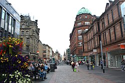
Buchanan Street is one of the main shopping thoroughfares in Glasgow, the largest city in Scotland. It forms the central stretch of Glasgow's famous shopping district with a generally more upmarket range of shops than the neighbouring streets: Argyle Street, and Sauchiehall Street.

The Argyle Line is a suburban railway located in West Central Scotland. The line serves the commercial and shopping districts of Glasgow's central area, and connects towns from West Dunbartonshire to South Lanarkshire. Named for Glasgow's Argyle Street, the line uses the earlier cut-and-cover tunnel running beneath that thoroughfare.

Cowcaddens is an area of the city of Glasgow, Scotland. It sits directly north of the city centre and is bordered by the newer area of Garnethill to the south-west and Townhead to the east.
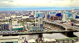
Anderston is an area of Glasgow, Scotland. It is on the north bank of the River Clyde and forms the south western edge of the city centre. Established as a village of handloom weavers in the early 18th century, Anderston was an independent burgh of barony from 1824 until it was incorporated into the City of Glasgow in 1846.
The city of Glasgow, Scotland, has a transport system encompassing air, rail, road and an underground light metro line. Prior to 1962, the city was also served by trams. Commuters travelling into Glasgow from the neighbouring local authorities of North and South Lanarkshire, Renfrewshire, East Renfrewshire, and East and West Dunbartonshire have a major influence on travel patterns, with tens of thousands of residents commuting into the city each day. The most popular mode of transport in the city is the car, used by two-thirds of people for journeys around the city.
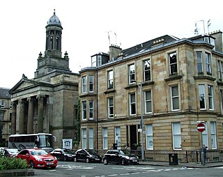
Blythswood Hill, crowned by Blythswood Square, is an area of central Glasgow, Scotland. Its grid of streets extend from the length of the west side of Buchanan Street to Gordon Street and Bothwell Street, and to Charing Cross, Sauchiehall Street and Garnethill. Developed from 1800 onwards, its Georgian and Victorian architecture is a Conservation Area. It started as the "Magnificent New Town of Blythswood", becoming a part of the city-centre's business and social life.

Sauchiehall Street is one of the main shopping streets in the city centre of Glasgow, Scotland, along with Buchanan Street and Argyle Street.
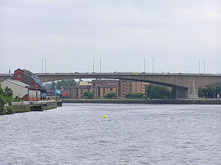
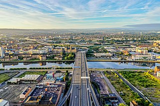
The Glasgow Inner Ring Road is a partially completed ring road encircling the city centre of Glasgow, Scotland. Construction of the roads began in 1965, and half of its circumference was completed by 1972 - forming part of the wider M8 motorway, but no further construction was made and the remaining plans were formally abandoned in 1980.
The Bruce Report is the name commonly given to the First Planning Report to the Highways and Planning Committee of the Corporation of the City of Glasgow published in March 1945. It influenced an intensive programme of regeneration and rebuilding efforts which took place in the city and surroundings from the mid-1950s and lasted until the late 1970s. The author was Robert Bruce, Glasgow Corporation Engineer at the time.

Charing Cross is a major road junction and area within the centre of Glasgow, Scotland. It is situated north of the River Clyde at the intersection of Sauchiehall Street, St George's Road, Woodlands Road, North Street and Newton Street, as well as being at a major interchange of the M8 motorway. Charing Cross marks the notional boundary between the City Centre and the West End of the city.

The A814 road in Scotland is a major arterial route within Glasgow, connecting the city centre to the west end. Running along the right (north) bank of the River Clyde, it continues further west through Clydebank and Dumbarton, leaving the suburban environment and serving as the main road for Helensburgh, turning north to meet the A83 at Arrochar, Argyll and Bute.

Glasgow Cross is at the hub of the ancient royal burgh and now city of Glasgow, Scotland, close to its first crossing over the River Clyde. It marks the notional boundary between the city centre and the East End
Bridge to Nowhere is a nickname used to refer to various unfinished structures around the M8 motorway in the centre of Glasgow, Scotland. They were built in the 1960s as part of the Glasgow Inner Ring Road project but left incomplete for several years. One "bridge", at Charing Cross, was completed in the 1990s as an office block. The Anderston Footbridge, a pedestrian bridge south of St Patrick's church, was finally completed in 2013 as part of a walking and cycling route.
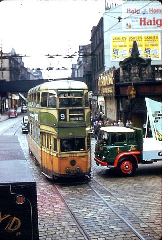
Glasgow Corporation Tramways were formerly one of the largest urban tramway systems in Europe. Over 1000 municipally-owned trams served the city of Glasgow, Scotland, with over 100 route miles by 1922. The system closed in 1962 and was the last city tramway in Great Britain.
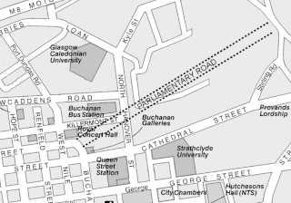
Parliamentary Road was a major street in the Townhead area of the city of Glasgow, Scotland, and was originally the district's main thoroughfare. Most of the street was removed by the late 1980s as part of successive regeneration schemes in Townhead and neighouring Cowcaddens, and as such almost none of the street remains evident to the present day.
Glasgow City Centre is the central business district of Glasgow, Scotland. Is bounded by Saltmarket, High Street and Castle Street to the east, The River Clyde to the south and the M8 motorway to its west and north. Glasgow City Centre is composed of the areas of Garnethill, Blythswood Hill and Merchant City as well as parts of Cowcaddens, Townhead, Anderston and Calton.
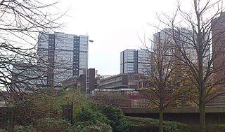
The Anderston Centre is a mixed-use commercial and residential complex, and former bus station located in the Anderston area of Glasgow, Scotland. Completed in 1972 and designed by Richard Seifert, it is one of the earliest examples of the "megastructure" style of urban renewal scheme fashionable in the 1950s and 1960s - the other notable example in Scotland being the infamous Cumbernauld Town Centre development. The complex is a notable landmark on the western edge of Glasgow city centre, and is highly visible from the adjacent Kingston Bridge.
North Street is a street in the city of Glasgow, Scotland. The street was formerly known as Lang Road.
Kelvingrove is a neighbourhood in the city of Glasgow, Scotland. It is situated north of the River Clyde in the West End of the city, and directly borders Kelvingrove Park to the north and the grounds of the Kelvingrove Art Gallery and Museum to the west. Its other boundaries are not precisely defined, but roughly correspond to Sauchiehall Street to the south opposite the Sandyford neighbourhood, and the Charing Cross area to the east.

Sandyford is an area of Glasgow, Scotland. It is north of the River Clyde and forms part of the western periphery of the city centre. Formerly the name of a ward under Glasgow Town Council in the first part of the 20th century, it is within a continuous area of fairly dense urban development bordering several other neighbourhoods whose mutual boundaries have blurred over time, and is possibly less well known than all of the places which adjoin it, particularly Anderston and Finnieston.