
Ellesmere Island is Canada's northernmost and third largest island, and the tenth largest in the world. It comprises an area of 196,236 km2 (75,767 sq mi), slightly smaller than Great Britain, and the total length of the island is 830 km (520 mi).

Grise Fiord is an Inuit hamlet on the southern tip of Ellesmere Island, in the Qikiqtaaluk Region, Nunavut, Canada. It is one of three populated places on the island; despite its low population, it is the largest community on Ellesmere Island. Created by the Canadian Government in 1953 through a relocation of Inuit families from Inukjuak, Quebec, it is Canada's northernmost public community. It is also one of the coldest inhabited places in the world, with an average yearly temperature of −16.5 °C (2.3 °F).
Quttinirpaaq National Park is located on the northeastern corner of Ellesmere Island in the Qikiqtaaluk Region of Nunavut, Canada. It is the second most northerly park on Earth after Northeast Greenland National Park. In Inuktitut, Quttinirpaaq means "top of the world". It was established as Ellesmere Island National Park Reserve in 1988, and the name was changed to Quttinirpaaq in 1999, when Nunavut was created, and became a national park in 2000. The reserve covers 37,775 km2 (14,585 sq mi), making it the second largest park in Canada, after Wood Buffalo National Park.

Nachvak Fjord is a deep fiord in northern Labrador nearly 2 km (1.2 mi) wide and 20 km (12 mi) long. The fjord is divided in two arms on the western end called Tallek Arm and Tasiuyak Arm. The Torngat Mountains that surround Nachvak Fjord are the highest in Labrador, where both Mount Razorback to the north and Mount Caubvick to the south are located.

The Strand Fiord Formation is a Late Cretaceous volcanic component, located on northwestern and west-central Axel Heiberg Island, Nunavut, Canada. The formation contains flood basalts which are found on western Axel Heiberg Island at Dragon Cliff 300 m (980 ft) tall.

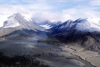
The Garfield Range is a mountain range on Ellesmere Island, Nunavut, Canada. The mountains are made of Paleozoic rocks and rise to heights between 1,067 m (3,501 ft) and 1,433 m (4,701 ft) and are separated by valleys through which flow the major rivers fed by the ice fields and glaciers. Like most of the mountain ranges in the Arctic, it is one of the world's northernmost mountain ranges.
Innuit Mountain is a mountain located 30 km (19 mi) northwest of Mount Caubvick in the Torngat Mountains of northern Labrador, Canada.

The Conger Range, also called the Conger Mountains, is a mountain range in Quttinirpaaq National Park on Ellesmere Island, Nunavut, Canada, beginning about 16 km (10 mi) west of Mount Osborne. It is part of the Arctic Cordillera which is a vast dissected mountain system extending from Ellesmere Island to the northernmost tip of Labrador and northeastern Quebec. The Conger Range is a structural extension of the Garfield Range and continues into the highlands north of the head of Hare Fiord. The overall extent of the range is about 180 km (112 mi). Most of its peaks are ice-covered, although nearly all of the southern slopes are ice-free. Many of the valleys between the peaks are filled with glacial tongues spilling out to the south from the Grand Land Ice Cap. Its highest point is Mount Biederbick at 1,542 m (5,059 ft).

The Osborn Range is a small mountain range located on the northwest flank of Tanquary Fiord on north-central Ellesmere Island, Nunavut, Canada. It lies just outside Quttinirpaaq National Park and is one of the northernmost mountain ranges in the world forming part of the Arctic Cordillera.
The Sawtooth Range is a jagged snow-capped mountain range on central Ellesmere Island, Nunavut, Canada. It lies between the Fosheim Peninsula and the Wolf Valley. The Sawtooth Range is a subrange of the Arctic Cordillera. It also runs through a Canadian Forces Station, called Eureka, a base used to study atmospheric changes.
Atagulisaktalik formerly known as Revoir Pass is a mountain pass in the central Baffin Mountains, Nunavut, Canada. It is named after the Revoir River.
Strand Fiord Pass is a mountain pass on southern Axel Heiberg Island, Nunavut, Canada.
Ukpik Peak is a mountain associated with the Baffin Mountains on Baffin Island, Nunavut, Canada.

Adams Island is an uninhabited island in the Qikiqtaaluk Region of Nunavut, Canada. The island is located in Baffin Bay off the northeastern coast of Baffin Island in the Arctic Archipelago. Nearby are Dexterity Island (northeast), Dexterity Fiord and Baffin Island (east), Tromso Fiord (south), Paterson Inlet (west), Bergesen Island (northwest), and Isbjorn Strait (north).

Kangiqtugaapik formerly Clyde Inlet is a body of water in eastern Baffin Island, Qikiqtaaluk Region, Nunavut. Its mouth opens into the Davis Strait from the west.
Nunatak Island is an uninhabited island in the Qikiqtaaluk Region of Nunavut, Canada. It is located at the northern end of Baffin Island's Cumberland Sound, at the junction of Shark Fiord and Clearwater Fiord. Southeast is Kekertelung Island. Anarnittuq Island, Clear Passage Island, and Iglunga Island are also located within this vicinity.
Borup Fiord is located on Ellesmere Island, Qikiqtaaluk Region, Nunavut Canada. The mouth of the fiord opens into Greely Fiord. To the west is Oobloyah Bay and to the north is the Neil Peninsula and the Neil Icecap. The eastern arm, known as Esayoo Bay leads to Borup Fiord Pass. Detailed studies of the Borup Fiord area between Oobloyah Bay and Esayoo Bay have been done in summer 1988 by geographers from Heidelberg University.
Arviqtujuq Kangiqtua formerly Eglinton Fiord is a fjord on Baffin Island's northeastern coast in the Qikiqtaaluk Region of Nunavut, Canada. The Inuit settlement of Pond Inlet is 355 km (221 mi) to the northwest and Clyde River is 55 km (34 mi) to the east.
Taitetimu / Caswell Sound is a fiord of the South Island of New Zealand. It is one of the fiords that form the coast of Fiordland.
Te Houhou / George Sound is a fiord of the South Island of New Zealand. It is one of the fiords that form the coast of Fiordland.
