
Baffin Island, in the Canadian territory of Nunavut, is the largest island in Canada, the second-largest island in the Americas, and the fifth-largest island in the world. Its area is 507,451 km2 (195,928 sq mi) with a population density of 0.03/km2; the population was 13,039 according to the 2021 Canadian census; and it is located at 68°N70°W. It also contains the city of Iqaluit, which is the capital of Nunavut.

Auyuittuq National Park is a national park located on Baffin Island's Cumberland Peninsula, in the Qikiqtaaluk Region of Nunavut, the largest political subdivision of Canada. The park was initially known as Baffin Island National Park when it was established in 1972, but the name was changed in 1976 to its current name to better reflect the region and its history. It features many terrains of Arctic wilderness, such as fjords, glaciers, and ice fields. Although Auyuittuq was established in 1972 as a national park reserve, it was upgraded to a full national park in 2000.

Sirmilik National Park is a national park located in Qikiqtaaluk, Nunavut, Canada, established in 1999. Situated within the Arctic Cordillera, the park is composed of three areas: most of Bylot Island with the exception for a few areas that are Inuit-owned lands, Kangiqłuruluk, and Baffin Island's Borden Peninsula. Much of the park is bordered by water.

The Arctic Cordillera is a terrestrial ecozone in northern Canada characterized by a vast, deeply dissected chain of mountain ranges extending along the northeastern flank of the Canadian Arctic Archipelago from Ellesmere Island to the northeasternmost part of the Labrador Peninsula in northern Labrador and northern Quebec, Canada. It spans most of the eastern coast of Nunavut with high glaciated peaks rising through ice fields and some of Canada's largest ice caps, including the Penny Ice Cap on Baffin Island. It is bounded to the east by Baffin Bay, Davis Strait and the Labrador Sea while its northern portion is bounded by the Arctic Ocean.

Qikiqtaaluk (ᕿᑭᖅᑖᓗᒃ) formerly Sillem Island is an uninhabited island in the Qikiqtaaluk Region of Nunavut, Canada. It is the second largest of the several hundred islands and islets that are located in Baffin Bay, immediately off the northern coast of Baffin Island. It is defined by Clark and Gibbs Fiords, which join at its northern end to form Scott Inlet. Further north lies Pilattuaq.

Qiajivik Mountain is a mountain in Qikiqtaaluk, Nunavut, Canada. Located in northeastern Baffin Island, it is part of the Baffin Mountains. At 1,965 m (6,447 ft) Qiajivik is the highest mountain in northern Baffin Island and with a topographic prominence of 1,787 m (5,863 ft) it is one of Canada's 142 ultra-prominent peaks.

The Baffin Mountains are a mountain range running along the northeastern coast of Baffin Island and Bylot Island, Nunavut, Canada. The ice-capped mountains are part of the Arctic Cordillera and have some of the highest peaks of eastern North America, reaching a height of 1,525–2,146 metres (5,003–7,041 ft) above sea level. While they are separated by bodies of water to make Baffin Island, they are closely related to the other mountain ranges that make the much larger Arctic Cordillera mountain range.

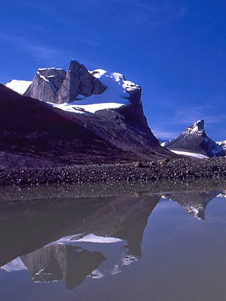
Mount Odin is a mountain in Qikiqtaaluk, Nunavut, Canada. It is located in Auyuittuq National Park along the Akshayuk Pass, 46 km (29 mi) north of Pangnirtung and south of Mount Asgard. Mount Odin is the highest mountain on Baffin Island.

The Byam Martin Mountains are a rugged mountain range extending the length of Bylot Island, Nunavut, Canada. It is one of the most northern ranges in the world and is an extension of the Baffin Mountains, which in turn form part of the Arctic Cordillera mountain system. The highest mountain in the range is Angilaaq Mountain at 1,951 m (6,401 ft), located near the island's center. Sharp peaks and ridges, divided by deep glacier-filled valleys, are typical features in the range and has been extensively modified by glacial erosion. The Byam Martin Mountains have not been conducive to habitation. While there are no permanent settlements in the Byam Martin Mountains, Inuit from Pond Inlet and elsewhere regularly travel to the range.
Angilaaq Mountain is a mountain in Qikiqtaaluk Region, Nunavut, Canada. It is located 62 km (39 mi) north of Pond Inlet. It is the highest mountain on Bylot Island and lies in the Byam Martin Mountains, which is a northern extension of the Baffin Mountains.
Breidablik Peak is a mountain on Baffin Island, located 51 km (32 mi) northeast of Pangnirtung, Nunavut, Canada. It lies in the southern Baffin Mountains which in turn form part of the Arctic Cordillera mountain system. Like Mounts Odin and Asgard and other peaks in the Arctic Cordillera, its name comes from Norse mythology. It is named after Breidablik, the home of Baldr.
Mount Baldr is a mountain on Baffin Island, located 49 km (30 mi) northeast of Pangnirtung, Nunavut, Canada. It lies in the southern Baffin Mountains, which in turn form part of the Arctic Cordillera mountain system. Like nearby Breidablik Peak and Mount Odin and other peaks in the Arctic Cordillera, its name comes from Norse mythology. It is named after Baldr, a god in Germanic paganism and is Odin's second son.
Akshayuk Pass formerly Pangnirtung Pass is a mountain pass in the Baffin Mountains of Nunavut, Canada. It is found within Auyuittuq National Park. To the southwest is Mount Thor, about 17 km (11 mi), and Pangnirtung, about 64 km (40 mi) and to the northeast is Qikiqtarjuaq, about 109 km (68 mi).

Midnight Sun Peak is a mountain in the Baffin Mountains, Baffin Island, Nunavut, Canada. It is part of the Auyuittuq National Park area with an elevation of 1,967 m (6,453 ft).
Kisimngiuqtuq Peak is a mountain in Qikiqtaaluk, Nunavut, Canada. It is associated with the Baffin Mountains on Baffin Island. It is the tenth highest peak in Nunavut and the eleventh highest peak in Nunavut by topographic prominence.
Bastille Peak is a mountain located 74 km (46 mi) north of Pangnirtung, Baffin Island, Nunavut, Canada. It is associated with the Baffin Mountains which in turn form part of the Arctic Cordillera mountain system.
Kangiqtualuk Uqquqti formerly Sam Ford Fiord is an isolated, elongated Arctic fjord on Baffin Island's northeastern coast in the Qikiqtaaluk Region of Nunavut, Canada. The Inuit settlement of Pond Inlet is 320 km (200 mi) to the northwest and Clyde River is 80 km (50 mi) to the east.

The Remote Peninsula is a peninsula located on the eastern coast of Baffin Island. It is part of the Qikiqtaaluk Region of the Canadian territory of Nunavut. The Inuit settlement of Pond Inlet is 295 km (183 mi) to the northwest and Clyde River is 90 km (56 mi) to the southeast.
