
Ellesmere Island is Canada's northernmost and third largest island, and the tenth largest in the world. It comprises an area of 196,236 km2 (75,767 sq mi), slightly smaller than Great Britain, and the total length of the island is 830 km (520 mi).
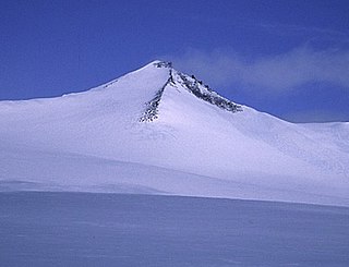
Barbeau Peak is a mountain in Qikiqtaaluk, Nunavut, Canada. Located on Ellesmere Island within Quttinirpaaq National Park, it is the highest mountain in Nunavut and the Canadian Arctic. The mountain was named in 1969 after Marius Barbeau, a Canadian anthropologist whose research into First Nations and Inuit cultures gained him international acclaim.

The British Empire Range is a mountain range on Ellesmere Island in Nunavut, Canada. The range is one of the most northern ranges in the world and the Arctic Cordillera, surpassed only by the Challenger Mountains which lies immediately to the northwest and the United States Range slightly further east. The highest mountain in the range is Barbeau Peak.
Mount Eugene is the highest mountain of the United States Range on Ellesmere Island. Originally named "Mount Arthur Eugene" in 1883 by the States Army Signal Service during their Lady Franklin Bay expedition.
Mount Whisler is a mountain of the British Empire Range on Canada's Ellesmere Island. It is the second highest peak of the British Empire Range, of Ellesmere Island, and of the Arctic Cordillera. It is located about 12 km (7.5 mi) northeast of Barbeau Peak, the highest peak in the Cordillera. The Henrietta Nesmith Glacier completely surrounds Mount Whisler.
Prince of Wales is the title traditionally given to the heir apparent to the reigning monarch of the United Kingdom.

The Arctic Cordillera is a terrestrial ecozone in northern Canada characterized by a vast, deeply dissected chain of mountain ranges extending along the northeastern flank of the Canadian Arctic Archipelago from Ellesmere Island to the northeasternmost part of the Labrador Peninsula in northern Labrador and northern Quebec, Canada. It spans most of the eastern coast of Nunavut with high glaciated peaks rising through ice fields and some of Canada's largest ice caps, including the Penny Ice Cap on Baffin Island. It is bounded to the east by Baffin Bay, Davis Strait and the Labrador Sea while its northern portion is bounded by the Arctic Ocean.

The Challenger Mountains are a mountain range on Ellesmere Island in Nunavut, Canada. The range is the most northern range in the world and of the Arctic Cordillera. The highest mountain in the range is Commonwealth Mountain 2,225 m (7,300 ft). The United States Range is immediately to the east of the Challenger Mountains.
The Victoria and Albert Mountains are a mountain range running on the east coast of Ellesmere Island, Nunavut, Canada. The range is one of the most northern ranges in the world and of the Arctic Cordillera. The highest mountain in the range is Agassiz Ice Cap Summit at 2,201 m (7,221 ft). The range has an area of 37,650 km2 (14,540 sq mi).
The Inglefield Mountains are a mountain range in southeastern Ellesmere Island, Nunavut, Canada. The mountain range is mostly covered by ice fields, with granitic nunataks reaching a height of 1,500 m (4,921 ft) above sea level. Rocky cliffs border the coastal areas. Like most other mountain ranges in the Canadian Arctic, the Inglefield Mountains are part of the Arctic Cordillera.
The Krieger Mountains are a mountain range near Oobloyah Bay in northern Ellesmere Island, Nunavut, Canada. The Kriegar Mountains contain Mesozoic stratigraphy.
The Blue Mountains are a small mountain range on Ellesmere Island, Nunavut, Canada. It is a subrange of the Arctic Cordillera. The Blue Mountains contain Mesozoic stratigraphy.

The Conger Range, also called the Conger Mountains, is a mountain range in Quttinirpaaq National Park on Ellesmere Island, Nunavut, Canada, beginning about 16 km (10 mi) west of Mount Osborne. It is part of the Arctic Cordillera which is a vast dissected mountain system extending from Ellesmere Island to the northernmost tip of Labrador and northeastern Quebec. The Conger Range is a structural extension of the Garfield Range and continues into the highlands north of the head of Hare Fiord. The overall extent of the range is about 180 km (112 mi). Most of its peaks are ice-covered, although nearly all of the southern slopes are ice-free. Many of the valleys between the peaks are filled with glacial tongues spilling out to the south from the Grand Land Ice Cap. Its highest point is Mount Biederbick at 1,542 m (5,059 ft).
The Thorndike Peaks are a mountain range located south of the entrance to Makinson Inlet, on the east coast of Ellesmere Island, Nunavut, Canada. They are part of the Arctic Cordillera and are virtually unexplored. There are no trees or wildlife in the Thorndike Peaks because the mountains are north of the Arctic tree line and because of the harsh cold climate.

The Osborn Range is a small mountain range located on the northwest flank of Tanquary Fiord on north-central Ellesmere Island, Nunavut, Canada. It lies just outside Quttinirpaaq National Park and is one of the northernmost mountain ranges in the world forming part of the Arctic Cordillera.
The Blackwelder Mountains are a small mountain range on Ellesmere Island, Nunavut, Canada. It is a subrange of the Arctic Cordillera.
The Sawtooth Range is a jagged snow-capped mountain range on central Ellesmere Island, Nunavut, Canada. It lies between the Fosheim Peninsula and the Wolf Valley. The Sawtooth Range is a subrange of the Arctic Cordillera. It also runs through a Canadian Forces Station, called Eureka, a base used to study atmospheric changes.

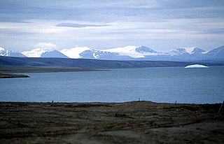
The Agassiz Ice Cap formerly Agassiz Glacier is an ice cap on the central eastern side of Ellesmere Island, Nunavut, Canada. The Agassiz ice cap is about 21,000 km2 (8,100 sq mi) in area. It is located between the North Ellesmere ice field to the north and the Prince of Wales Icefield to the south.
Augusta Bay is a bay of the Ellesmere Island, Nunavut, Canada. Meltwater from the Prince of Wales Icefield channels into the bay with its mouth opening into the Bay Fiord.
The Eurekan orogeny was a Phanerozoic mountain building event that affected the eastern portion of the Arctic Archipelago and, to a lesser extent, northern Greenland. Deformation initiated in the Late Cretaceous, during which time the Sverdrup Basin began to fragment and fold in response to the counterclockwise rotation of Greenland, caused by seafloor spreading in the Canadian Arctic Rift System. Isostatic uplift was most pronounced in the Grantland Mountains and Victoria and Albert Mountains on Ellesmere Island and in the Princess Margaret Range on Axel Heiberg Island, as evidenced by the current physiography. Compression in a broad zone on Ellesmere Island resulted in the formation of the Eurekan Fold Belt.
