
Bylot Island lies off the northern end of Baffin Island in Nunavut Territory, Canada. Eclipse Sound to the southeast and Navy Board Inlet to the southwest separate it from Baffin Island. Parry Channel lies to its northwest. At 11,067 km2 (4,273 sq mi) it is ranked 71st largest island in the world and Canada's 17th largest island. The island measures 180 km (110 mi) east to west and 110 km (68 mi) north to south and is one of the largest uninhabited islands in the world. While there are no permanent settlements on this Canadian Arctic island, Inuit from Pond Inlet and elsewhere regularly travel to Bylot Island. An Inuit seasonal hunting camp is located southwest of Cape Graham Moore.

Auyuittuq National Park is a national park located on Baffin Island's Cumberland Peninsula, in the Qikiqtaaluk Region of Nunavut, the largest political subdivision of Canada. The park was initially known as Baffin Island National Park when it was established in 1972, but the name was changed in 1976 to its current name to better reflect the region and its history. It features many terrains of Arctic wilderness, such as fjords, glaciers, and ice fields. Although Auyuittuq was established in 1972 as a national park reserve, it was upgraded to a full national park in 2000.

Mount Asgard is a twin peaked mountain with two flat-topped, cylindrical, rock towers, separated by a saddle. It is located in Auyuittuq National Park, on the Cumberland Peninsula of Baffin Island, Nunavut, Canada. The peak is named after Asgard, the realm of the Æsir (gods) in Norse mythology. Mount Asgard is perhaps the most famous of the Baffin Mountains.

Mount Thor, officially gazetted as Thor Peak, in Nunavut, Canada, is a mountain with an elevation of 1,675 m (5,495 ft) located in Auyuittuq National Park, on Baffin Island. The mountain is located 46 km (29 mi) northeast of Pangnirtung and features Earth's greatest vertical drop of 1,200 m (4,100 ft), with the cliff overhanging at an average angle of 105 degrees. Despite its remoteness, this feature makes the mountain a popular rock climbing site. Camping is allowed, with several designated campsites located throughout the length of Akshayuk Pass. For climbers looking to scale Mount Thor, there is an established campsite a few kilometres north of its base, complete with windbreaks and emergency shelters.

Qiajivik Mountain is a mountain in Qikiqtaaluk, Nunavut, Canada. Located in northeastern Baffin Island, it is part of the Baffin Mountains. At 1,965 m (6,447 ft) Qiajivik is the highest mountain in northern Baffin Island and with a topographic prominence of 1,787 m (5,863 ft) it is one of Canada's 142 ultra-prominent peaks.

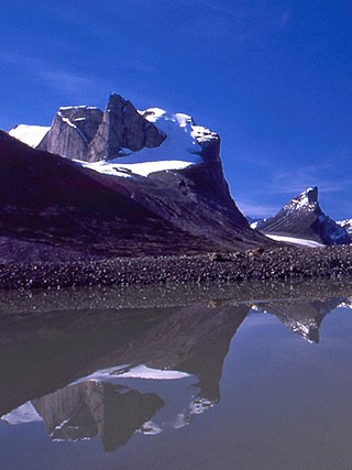
The Baffin Mountains are a mountain range running along the northeastern coast of Baffin Island and Bylot Island, Nunavut, Canada. The ice-capped mountains are part of the Arctic Cordillera and have some of the highest peaks of eastern North America, reaching a height of 1,525–2,146 metres (5,003–7,041 ft) above sea level. While they are separated by bodies of water to make Baffin Island, they are closely related to the other mountain ranges that make the much larger Arctic Cordillera mountain range.

Mount Odin is a mountain in Qikiqtaaluk, Nunavut, Canada. It is located in Auyuittuq National Park along the Akshayuk Pass, 46 km (29 mi) north of Pangnirtung and south of Mount Asgard. Mount Odin is the highest mountain on Baffin Island.
Cirque Mountain is a mountain located 11 km (7 mi) northeast of Mount Caubvick, in Labrador, Canada. It is the third-highest mountain in Labrador, after Caubvick (1,652 m) and Torngarsoak Mountain (1,595 m), and lies in the Selamiut Range, which is a subrange of the Torngat Mountains. Before 1971, it was believed that Cirque Mountain was the highest peak in Canada east of the Rocky Mountains and south of Baffin Island; that distinction is now known to belong to Mount Caubvick.
The Hartz Mountains are a mountain range on Baffin Island, Nunavut, Canada. It is located in Sirmilik National Park which is Baffin Island's northernmost national park. It makes up part of the Arctic Cordillera mountain system.
The Krag Mountains are a mountain range on northern Baffin Island, Nunavut, Canada. It is part of a much larger mountain range called the Baffin Mountains which in turn form part of the Arctic Cordillera mountain system.
Breidablik Peak is a mountain on Baffin Island, located 51 km (32 mi) northeast of Pangnirtung, Nunavut, Canada. It lies in the southern Baffin Mountains which in turn form part of the Arctic Cordillera mountain system. Like Mounts Odin and Asgard and other peaks in the Arctic Cordillera, its name comes from Norse mythology. It is named after Breidablik, the home of Baldr.
Mount Baldr is a mountain on Baffin Island, located 49 km (30 mi) northeast of Pangnirtung, Nunavut, Canada. It lies in the southern Baffin Mountains, which in turn form part of the Arctic Cordillera mountain system. Like nearby Breidablik Peak and Mount Odin and other peaks in the Arctic Cordillera, its name comes from Norse mythology. It is named after Baldr, a god in Germanic paganism and is Odin's second son.
Akshayuk Pass formerly Pangnirtung Pass is a mountain pass in the Baffin Mountains of Nunavut, Canada. It is found within Auyuittuq National Park. To the southwest is Mount Thor, about 17 km (11 mi), and Pangnirtung, about 64 km (40 mi) and to the northeast is Qikiqtarjuaq, about 109 km (68 mi).

Midnight Sun Peak is a mountain in the Baffin Mountains, Baffin Island, Nunavut, Canada. It is part of the Auyuittuq National Park area with an elevation of 1,967 m (6,453 ft).
Mount Battle is a mountain located 65 km (40 mi) northeast of Pangnirtung on Baffin Island, Nunavut, Canada. It is part of the Baffin Mountains which in turn form part of the Arctic Cordillera mountain system.
Kisimngiuqtuq Peak is a mountain in Qikiqtaaluk, Nunavut, Canada. It is associated with the Baffin Mountains on Baffin Island. It is the tenth highest peak in Nunavut and the eleventh highest peak in Nunavut by topographic prominence.
Bastille Peak is a mountain located 74 km (46 mi) north of Pangnirtung, Baffin Island, Nunavut, Canada. It is associated with the Baffin Mountains which in turn form part of the Arctic Cordillera mountain system.
Angna Mountain is a mountain located on Baffin Island, Nunavut, Canada. It is associated with the Baffin Mountains which in turn form part of the Arctic Cordillera mountain system.
Mount Thule is a mountain on Bylot Island, Nunavut, Canada. It is located 38 km (24 mi) north of Pond Inlet on Baffin Island. It is associated with the Baffin Mountains which in turn form part of the Arctic Cordillera mountain system. The area around Mount Thule is permanently covered in ice and snow.
Kanajjut, formerly Wight Inlet, is a body of water in Nunavut's Qikiqtaaluk Region. It lies in western Hudson Strait, forming a wedge into Baffin Island's Meta Incognita Peninsula and the western slopes of the Everett Mountains.
