

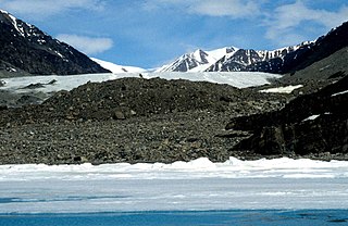
Sermilik Glacier is a glacier located in the southern Byam Martin Mountains of Bylot Island, Nunavut, Canada. [1] It lies in Sirmilik National Park.
Sermilik Glacier is a glacier located in the southern Byam Martin Mountains of Bylot Island, Nunavut, Canada. [1] It lies in Sirmilik National Park.

The Arctic Archipelago, also known as the Canadian Arctic Archipelago, groups together all islands lying to the north of the Canadian continental mainland excluding Greenland.
Baberton is a suburb of Edinburgh, the capital of Scotland. It is south-west of the Edinburgh City Bypass and Wester Hailes and south of the Shotts Line railway line. The village of Juniper Green is situated to the south of Baberton and Baberton Golf Course is to the west.

Glacier morphology, or the form a glacier takes, is influenced by temperature, precipitation, topography, and other factors. The goal of glacial morphology is to gain a better understanding of glaciated landscapes, and the way they are shaped. Types of glaciers can range from massive ice sheets, such as the Greenland ice sheet, to small cirque glaciers found perched on mountain tops. Glaciers can be grouped into two main categories:

The Byam Martin Mountains are a rugged mountain range extending east to west across Bylot Island, Nunavut, Canada. It is one of the most northern ranges in the world and is an extension of the Baffin Mountains which in turn form part of the Arctic Cordillera mountain system. The highest mountain in the range is Angilaaq Mountain, 1,951 m (6,401 ft), located near the island's center. Sharp peaks and ridges, divided by deep glacier-filled valleys are typical features in the range and has been extensively modified by glacial erosion. The Byam Martin Mountains have not been conducive to habitation. While there are no permanent settlements in the Byam Martin Mountains, Inuit from Pond Inlet and elsewhere regularly travel to the range.
Benedict Glacier is a glacier on central Ellesmere Island, Nunavut, Canada.
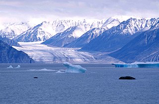
Kaparoqtalik Glacier is a glacier located in the southern coast of the Byam Martin Mountains on Bylot Island, Nunavut, Canada. It lies in Sirmilik National Park.
Narsarsuk Glacier is a glacier in the southeastern Byam Martin Mountains of Bylot Island, Nunavut, Canada.
Jimi Maasi Glacier is a glacier in northeastern Baffin Island, Nunavut, Canada.
Macculloch Glacier is a glacier located in the northeastern coast of the Baffin Mountains on Baffin Island, Nunavut, Canada.
Oliver Glacier is a glacier located on the northeast coast of the Baffin Mountains on Baffin Island, Nunavut, Canada. It is just outside Sirmilik National Park.
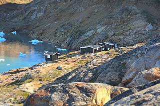
Sermilik Station is a glaciology research station on Ammassalik Island, dedicated to the research of the nearby Mittivakkat Glacier. The station is located approximately at 65°41′N37°55′W on the west side of the Ammasalik island in south east Greenland, on the shore of the Sermilik Fjord. The station is not permanently staffed. However, during most times in summer they will have researchers working there.
The Raanes Peninsula is located on the southwestern coast of Ellesmere Island, a part of the Qikiqtaaluk Region of the Canadian territory of Nunavut. Axel Heiberg Island is approximately 15 km (9.3 mi) to the west.
The Johan Peninsula is located on the eastern coast of Ellesmere Island, a part of the Qikiqtaaluk Region of the Canadian territory of Nunavut. It stretches eastward into Nares Strait. Buchanan Bay is to the north, Rosse Bay to the east, and Baird Inlet lies to the south.

Augusta Bay is a bay of the Ellesmere Island, Nunavut, Canada, located at coordinates 78°53′N81°45′W. Meltwater from the Prince of Wales Icefield channels into the bay with its mouth opening into the Bay Fiord.

Midgard Glacier is a glacier on the east coast of the Greenland ice sheet.

Sermilik is a fjord in eastern Greenland. It is part of the Sermersooq municipality.

Southern Sermilik is a fjord in southwestern Greenland. Administratively it is part of the Kujalleq municipality.

Ikersuaq, old spelling Ikerssuak, is a fjord in southwestern Greenland. Administratively it is part of the Kujalleq municipality.
Connecticut Lakes State Forest is a 1,648-acre (667 ha) state forest in the town of Pittsburg, New Hampshire, in the United States. The forest forms a narrow strip on either side of U.S. Route 3, running south from the Canadian border around Third and south past Second Connecticut Lake before ending up short of First Connecticut Lake. The area is known for its moose viewing opportunities in late spring and summer during the mornings and evenings, earning it the name nickname "Moose Alley".
Coordinates: 72°54′43″N078°11′42″W / 72.91194°N 78.19500°W
| This Qikiqtaaluk Region, Nunavut location article is a stub. You can help Wikipedia by expanding it. |
| This article about a glacier in Canada is a stub. You can help Wikipedia by expanding it. |