
Bledlow Ridge is a village in the civil parish of Bledlow-cum-Saunderton in Buckinghamshire, England. In 2004 the population was 940. It is situated in the Chiltern Hills, about 4 miles SSW of Princes Risborough and on the road between the High Wycombe and Chinnor.

Cotes is a hamlet and very small civil parish near the town of Loughborough in Leicestershire, England.Cotes has a population of about 50. At the 2011 census the population remained less than 100 and was included in the civil parish of Burton on the Wolds.

The Dornoch Firth is a firth on the east coast of Highland, in northern Scotland. It forms part of the boundary between Ross and Cromarty, to the south, and Sutherland, to the north. The firth is designated as a national scenic area, one of 40 such areas in Scotland. The national scenic area covers 15,782 ha in total, of which 4,240 ha is the marine area of the firth below low tide. A review of the national scenic areas by Scottish Natural Heritage in 2010 commented:
By comparison with other east coast firths the Dornoch Firth is narrow and sinuous, yet it exhibits within its compass a surprising variety of landscapes. It is enclosed by abrupt rounded granitic hills clad in heather moor and scree, their Gaelic names of cnoc, meall and creag giving the clue to their character. Their lower slopes are frequently wooded, oakwoods being a noticeable feature of the area, but with other deciduous and coniferous species represented in plantations which vary from the policy plantings of Skibo Castle to the pines of the Struie Forest.

Cowshill is a village in County Durham, England. It is situated at the top of Weardale, between Lanehead and Wearhead. In the 2001 census Cowshill had a population of 156.
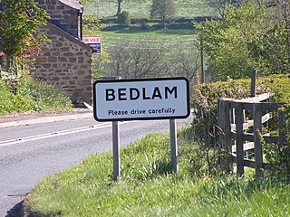
Bedlam is a small village in the Harrogate district of North Yorkshire, England situated north of Harrogate.

Borrowdale is a valley in the English Lake District. It is located in the old county of Westmorland, and is sometimes referred to as Westmorland Borrowdale in order to distinguish it from a more famous Borrowdale located in the traditional county of Cumberland.
Bridgeyate is a hamlet in South Gloucestershire, England. Bridgeyate is situated between the cities of Bristol and Bath. The increase in housebuilding in the area has seen Bridgeyate become attached to the nearby villages of Warmley and North Common, but it still retains its own identity with a large common and three public houses, The Griffin, The White Hart and The Hollybush. The Hollybush reopened in March 2014 after an extensive refit.

Azerley is a village and civil parish in the Harrogate district of North Yorkshire, England. It is about 4 miles (6 km) north-west of Ripon.
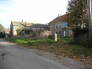
Barden is a village and civil parish in the Richmondshire district of North Yorkshire, England. It is about 5 miles (8 km) south of Richmond. According to the 2001 census the parish had a population of 49, remaining at less than 100 in the 2011 Census. Population information is kept in the parish of Hauxwell.

Barrow is a civil parish, in the unitary authority of Cheshire West and Chester and the ceremonial county of Cheshire, England. The civil parish contains the village of Great Barrow and the hamlets of Little Barrow, Broomhill and Stamford Bridge. Great Barrow is situated about 4.5 miles east-north-east of Chester, 6 miles north-west of Tarporley and 6 miles south of Frodsham.

Bishop Thornton is a village in the civil parish of Bishop Thornton, Shaw Mills and Warsill, in the Harrogate district of North Yorkshire, England. According to the 2001 census it had a population of 521, decreasing to 507 at the 2011 census. The village is about seven miles north of Harrogate.
Croxdale and Hett is a civil parish in County Durham, England. It is situated approximately four miles south of Durham. The population of the civil parish as taken at the 2011 census was 866.

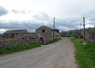
Caldbergh is a hamlet within the Yorkshire Dales, North Yorkshire, England. It lies about four miles south of Leyburn. East Scrafton and Coverham are nearby.

The A104 is an A road in London, England. It runs from Islington Green to Epping.
Burrill is a small village in the Hambleton district of North Yorkshire, England. It is in the parish of Burrill with Cowling and 1 mile west of Bedale.
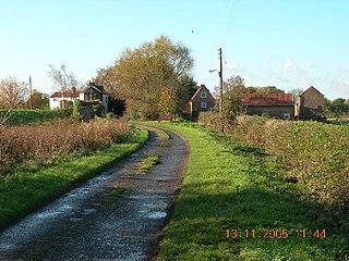
Booth is a hamlet near Goole, in the East Riding of Yorkshire, England. Booth is also known as Boothferry or Boothferry Bridge.

Glasinfryn is a small village in Gwynedd, Wales. It is situated between the village of Tregarth and the city of Bangor, Gwynedd, and in the community of Pentir. The village is residential in nature but with many outlying farms.

Ordnance Survey (OS) is the national mapping agency for Great Britain. The agency's name indicates its original military purpose, which was to map Scotland in the wake of the Jacobite rising of 1745. There was also a more general and nationwide need in light of the potential threat of invasion during the Napoleonic Wars. Since 1 April 2015 Ordnance Survey has operated as Ordnance Survey Ltd, a government-owned company, 100% in public ownership. The Ordnance Survey Board remains accountable to the Secretary of State for Business, Energy and Industrial Strategy. It was also a member of the Public Data Group.

Dun is a rural parish in Angus, Scotland. It contains the House of Dun, home of the Erskine family and is a stop on the Caledonian Railway. It is located on the river South Esk, west of Montrose and east of Brechin. In 1785-7 a bridge was built there across the South Esk. The writer Violet Jacob was born at the House of Dun. William Chalmers Burns, a famous Scottish evangelist was born at Dun in 1815.

Bridge of Alford is a village in Aberdeenshire, Scotland.

