
Dunnet Head is a peninsula in Caithness, on the north coast of Scotland. Dunnet Head includes the most northerly point of both mainland Scotland and the island of Great Britain.

Glunimore Island is an uninhabited island around 3 miles southeast of the Kintyre peninsula, Scotland. It lies alongside Sanda Island and Sheep Island

Airlie is a civil parish in the Scottish council area of Angus. It is the seat of the Earl of Airlie, and the location of Airlie Castle. It comprises Craigton of Airlie, Baitland of Airlie and Kirkton of Airlie. There is a standing stone in a field just east of the Baitland; various Pictish and Roman relics have been uncovered and the primary school is reputed to have been built on the site of an old graveyard. Airlie also contains one of the finest examples of a Pictish souterrain in Scotland, with the carving of a snake clearly visible in the ceiling.

Barrow is a civil parish containing the villages of Great Barrow, Little Barrow and Stamford Bridge. It is situated about 4.5 miles east-north-east of Chester, 6 miles north-west of Tarporley, and 6 miles south of Frodsham.

Morvern, historically also spelt Morven, is a peninsula and traditional district in the Highlands, on the west coast of Scotland. It lies south of the districts of Ardgour and Sunart, and is bounded on the north by Loch Sunart and Glen Tarbert, on the south east by Loch Linnhe and on the south west by the Sound of Mull. The name is derived from the Gaelic A' Mhorbhairne. The highest point is the summit of the Corbett Creach Bheinn which reaches 853 metres (2,799 ft) in elevation.
Bridge of Craigisla is a hamlet in Angus, Scotland. The bridge crosses the River Isla. This settlement lies along the B954 road.
The Douglas Water is a river in South Lanarkshire of south-central Scotland. It is a tributary of the River Clyde.

Eastriggs is a small village located in Dumfries and Galloway in the south of Scotland, the village is located around 2 mi (3.2 km) north of the mud and sandbanks of the channel of the River Eden, which extends west into the Solway Firth.

Foveran is the name of both a parish and village in Aberdeenshire, Scotland. The village is located 11 miles north of Aberdeen and four miles southeast of Ellon; the main group of houses and the village school are located adjacent to the main A90 trunk road.

Auchleven is a village in Aberdeenshire, Scotland. Located approximately 4 miles south of Insch, 17 mi (27 km) south of Huntly and 12 mi (19 km) north-west of Inverurie.

Backwater Reservoir is a reservoir in north west Angus, Scotland. The reservoir's sole purpose is to provide drinking water, and as such, it supplies Angus, Dundee, and parts of Perth and Kinross. Backwater, together with the smaller Lintrathen Reservoir 4 kilometres to the south, is capable of supplying some 300,000 people with drinking water.

Farr is a parish in the county of Sutherland in the Scottish council area of Highland. The parish also includes a small hamlet named Farr. The village of Bettyhill lies less than 1 mile to the west of the hamlet along the A836 road.

The A970 is a single-carriageway road that runs from south to north of Mainland Shetland, Scotland. The road also spurs to Scalloway and North Roe.

The Antonine Wall, known to the Romans as Vallum Antonini, was a turf fortification on stone foundations, built by the Romans across what is now the Central Belt of Scotland, between the Firth of Forth and the Firth of Clyde. Representing the northernmost frontier barrier of the Roman Empire, it spanned approximately 63 kilometres and was about 3 metres high and 5 metres wide. Lidar scans have been carried out to establish the length of the wall and the Roman distance units used. Security was bolstered by a deep ditch on the northern side. It is thought that there was a wooden palisade on top of the turf. The barrier was the second of two "great walls" created by the Romans in Great Britain. Its ruins are less evident than those of the better-known Hadrian's Wall to the south, primarily because the turf and wood wall has largely weathered away, unlike its stone-built southern predecessor.
Balintore is a village in Angus, Scotland. It lies in Glen Isla, four miles north of the Loch of Lintrathen and seven miles west of Kirriemuir. Approximately half a mile to the east is Knowehead of Auldallan farm, where there can be found a pair of uninscribed standing stones.
Little Brechin is a village in Angus, Scotland. It lies approximately two miles north of Brechin on the north side of the A90 road.
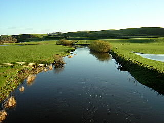
Kirkton of Glenisla is a village in Glen Isla, Angus, Scotland. It is situated on the River Isla, eleven miles north-west of Kirriemuir and ten miles north of Blairgowrie, on the B951 road. The village consists of a church and graveyard, a hotel, and several holiday cottages. The village is situated adjacent to the 64 mile waymarked Cateran Trail. There is a suspension footbridge that was built in 1824 over the River Isla.
Brewlands Bridge is a hamlet in Glen Isla, Angus, Scotland. It is lies situated on the River Isla, eleven miles north-west of Kirriemuir and ten miles north of Blairgowrie, on the B951 road.
Folda is a hamlet in Glen Isla, Angus, Scotland. It is situated on the River Isla, twelve miles north-west of Kirriemuir and eleven miles north of Blairgowrie, on the B951 road.
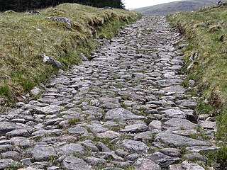
A network of military roads, sometimes called General Wade's Military Roads, was constructed in the Scottish Highlands during the middle part of the 18th century as part of an attempt by the British Government to bring order to a part of the country which had risen up in the Jacobite rebellion of 1715.

