
Angus is one of the 32 local government council areas of Scotland, a registration county and a lieutenancy area. The council area borders Aberdeenshire, Dundee City and Perth and Kinross. Main industries include agriculture and fishing. Global pharmaceuticals company GSK has a significant presence in Montrose in the north of the county.

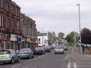
Arbroath or Aberbrothock is a former royal burgh and the largest town in the council area of Angus in Scotland, and has a population of 23,902. It lies on the North Sea coast, around 16 miles (25.7 km) ENE of Dundee and 45 miles (72.4 km) SSW of Aberdeen.

The A92 is a major highway that runs through Fife, Dundee, Angus, Aberdeenshire, and Aberdeen City in Scotland. From south to north, it runs from Dunfermline to Blackdog, just north of Aberdeen.

Carnoustie is a town and former police burgh in the council area of Angus, Scotland. It is at the mouth of the Barry Burn on the North Sea coast. In the 2011 census, Carnoustie had a population of 11,394, making it the fourth largest town in Angus.

Angus is a county constituency of the House of Commons of the Parliament of the United Kingdom. It elects one Member of Parliament (MP) by the first-past-the-post voting system. It is currently represented by Dave Doogan of the Scottish National Party who has been the MP since 2019.
Angus East was a Scottish county constituency represented in the House of Commons of the Parliament of the United Kingdom from 1983 until 1997, when it was replaced largely by Angus with smaller proportions moving to Tayside North, Dundee East and Dundee West. Between 1950 and 1983, the area had been represented by the North Angus & Mearns and South Angus constituencies.
Monifieth is a town and former police burgh in the council area of Angus, Scotland. It is situated on the north bank of the Firth of Tay on the east coast. In 2016, the population of Monifieth was estimated at 8,110, making it the fifth largest town in Angus.
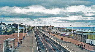
Carnoustie railway station is an unstaffed railway station which serves the town of Carnoustie, Angus, Scotland.

Letham is a village in Angus, Scotland.
Newbigging is a village in Angus, Scotland, two miles north-east of Dundee. The name "Newbigging" originally referred to a "new bigging" or "new cottar town" (hamlet). The village is roughly two miles north of Monifieth and east of Dundee, Scotland's fourth city. Some of the earliest history of the local area is represented approximately four kilometres northwest at the village of Eassie, where the Eassie Stone is displayed in a ruined church; this carved Pictish stone is dated prior to the Early Middle Ages.

Thomas Lowson is traditionally thought to be the founder of the town of Carnoustie, Angus.

The Camus Cross, otherwise known as the Camuston or Camustane Cross, is an Early Medieval Scottish standing stone located on the Panmure Estate near Carnoustie in Angus, Scotland. First recorded in the 15th century in a legal document describing the boundaries between Camuston and the barony of Downie, and described in the 17th century by Robert Maule, it is a freestanding cross, rare in Eastern Scotland.
Muirdrum is a small village in the council area of Angus, Scotland. It is situated at the junction of the old A92 road from Dundee to Arbroath, the A930 to Carnoustie and B9128 to Forfar. Its closest town is Carnoustie, which lies approximately 2 km (1 mi) to the south.
Upper Victoria is a hamlet in Angus, Scotland. It lies on the A92 road between Arbroath and Dundee and is the location of the junction of the A92 and the Marches, the Craigton to Carnoustie road, forming the main route into Carnoustie.
Balmirmer is a hamlet in the council area of Angus, Scotland. It is situated 2 miles (3 km) north-east of Carnoustie and 4 miles (6 km) west of Arbroath. The hamlet is the location of West Balmirmer Farm, the birthplace of Margaret Fairlie, the first woman to hold a university chair in Scotland.
Salmond's Muir is a hamlet in the council area of Angus, Scotland. It is situated 2 miles (3 km) north-east of Carnoustie and 4 miles (6 km) west of Arbroath on the A92 road. The junction of the A92 at Salmond's Muir forms the main route to the villages of Panbride, East Haven, Balmirmer and Scryne.
Woodhill is a settlement in Angus, Scotland. It lies at a central point between Carnoustie and Monifieth on the east on an unclassified road linking the A92 and A930 roads. Woodhill House was erected in 1604 by William Auchinleck, who later became Provost of Dundee. It was demolished and rebuilt in 1908.
Clayholes is a small hamlet in Angus, Scotland. It lies approximately 0.5 kilometres (0.31 mi) north of Carnoustie on the unclassified Balmachie road, that connects the A930 road in Carnoustie with the A92 road at Balmachie.

Carnoustie High School is a comprehensive secondary school in Carnoustie, Angus, Scotland. Situated to the north of the town, the school serves Carnoustie and surrounding villages, including Barry, Monikie, Newbigging, Craigton, Muirdrum, Panbride and Easthaven.

Dundee and Angus College is a further education college in the Tayside region of Scotland. It was created on 1 November 2013 as a merger of Angus College and Dundee College. It is the only college in Dundee, and, with approximately 23,000 enrolments, is one of the largest in the country.
