Monikie

Last updated

Monikie
Angus UK location map.svg
Red pog.svg
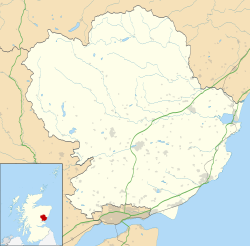
Monikie
Location within Angus
Populationest. 479. [1] (1991)
OS grid reference NO499387
Council area
Lieutenancy area
Country Scotland
Sovereign state United Kingdom
Post town DUNDEE
Postcode district DD5
Dialling code 01382
Police Scotland
Fire Scottish
Ambulance Scottish
UK Parliament
Scottish Parliament
List of places
UK
Scotland
56°32′15″N2°48′58″W / 56.537624°N 2.816236°W / 56.537624; -2.816236

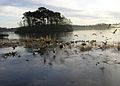
Monikie is a village and civil parish in Angus, Scotland, north-east of Dundee. [2]

Contents

History

The village grew from small beginnings as just one of many hamlets. The other large village in the parish is Newbigging. Because of the siting of the Railway Station, provided mainly to service the farming community and latterly, the Farina Mill or Granary, and the former reservoir ponds for Dundee City Council (now Monikie Country Park), the concentration has centred on the area which became Monikie village, mainly as a result of a new house building programme in the 1970s and 1980s.

The Scottish violinist and fiddler James Scott Skinner lived in Monikie from 1906 to 1909.

It is wrong to think of Monikie as only the village but, as the parish name, it is still relevant in most of the addresses in this rural area, stretching from Hynd Castle in the north, to the coast of the Firth of Tay at the south. Its population in 1991 was 479. [3] There has been a fair bit of development with some new housing in the village since the 1991 figure and the population has increased. Monikie is the northernmost Church of Scotland parish of the Presbytery of Dundee, but changes have occurred.

A rare example of a morthouse is located in the churchyard, built to frustrate the activities of 19th century bodysnatchers.

Landmarks

It is the location of Affleck Castle , formerly Auchinleck Castle, which stands on the western outskirts of the village toward the centre of the parish. It consists of a tower built on high ground. The castle was inhabited as late as 1746, although it has since been used as a granary. The 17th-century Panmure House, seat of the Earl of Panmure, was located to the east of the village, although it was demolished in the 1950s. Only the stables and the 105-foot (32 m) Panmure Testimonial remain on the estate, as well as the remains of the earlier Panmure Castle.

Amenities

Monikie has a coffee shop called “Sweet Nix”. There is also a cafe/restaurant in the country park called “Cafe Byzantium” which operates late spring to early autumn. Monikie also has a number of local groups and clubs which run at the Monikie Memorial Hall.

Monikie Scout Hut is the home to the 53rd Angus (1st Newbigging) Scout Group, providing activities for boys and girls aged 6 –14. The Camus Explorer Scout Unit (boys and girls aged 14–17) as well as the Monikie Rainbows and Brownies also use the Scout Hut.

Monikie Country Park also provides a number of nature based activities as well as providing Outdoor activities such as water sports, high ropes and climbing activities during the summer months.

Buses

Moffat & Williamson operate a two-hourly bus service, numbered the 78 & 79, which both go from Monikie to Dundee via Broughty Ferry daily. The buses stop at Broomwell Gardens, Monikie Country Park [lower-alpha 1] and Monikie Primary School. [4] Stagecoach Strathtay operate a one-bus-a-day service, numbered the 181, which goes from Monikie to Forfar or Monifieth on Mondays, Wednesdays and Fridays only. [5]

Notes

  1. Buses serve Monikie Country Park on Sundays only

Related Research Articles

<span class="mw-page-title-main">Angus, Scotland</span> Council area of Scotland

Angus is one of the 32 local government council areas of Scotland, a registration county and a lieutenancy area. The council area borders Aberdeenshire, Dundee City and Perth and Kinross. Main industries include agriculture and fishing. Global pharmaceuticals company GSK has a significant presence in Montrose in the east of the county.

<span class="mw-page-title-main">Forfar</span> County town and administrative centre in Scotland

Forfar is the county town of Angus, Scotland and the administrative centre for Angus Council, with a new multi-million pound office complex located on the outskirts of the town. As of 2021, the town has a population of 16,280.

<span class="mw-page-title-main">Broughty Ferry</span> Suburb of Dundee, Scotland

Broughty Ferry is a suburb of Dundee, Scotland. It is situated four miles east of the city centre on the north bank of the Firth of Tay. The area was a separate burgh from 1864 until 1913, when it was incorporated into Dundee. Historically it is within the County of Angus.

<span class="mw-page-title-main">Carnoustie</span> Town in Angus, Scotland

Carnoustie is a town and former police burgh in the council area of Angus, Scotland. It is at the mouth of the Barry Burn on the North Sea coast. In the 2011 census, Carnoustie had a population of 11,394, making it the fourth-largest town in Angus. The town was founded in the late 18th century, and grew rapidly throughout the 19th century due to the growth of the local textile industry. It was popular as a tourist resort from the early Victorian era up to the latter half of the 20th century, due to its seaside location, and is best known for the Carnoustie Golf Links course that often hosts the Open Championship.

<span class="mw-page-title-main">Monifieth</span> Town in Angus, Scotland

Monifieth is a town and former police burgh in the council area of Angus, Scotland. It is situated on the north bank of the Firth of Tay on the east coast. In 2016, the population of Monifieth was estimated at 8,110, making it the fifth largest town in Angus.

<span class="mw-page-title-main">East Haven, Angus</span> Human settlement in Scotland

East Haven is a fishing village in the council area of Angus, Scotland. It is situated 1.5 miles (2 km) east of Carnoustie and 5 miles (8 km) south west of Arbroath. The closest city, Dundee, is 13 miles (21 km) to the west.

<span class="mw-page-title-main">Seagate bus station</span> Bus station in Dundee, Scotland

Seagate bus station serves Dundee, Scotland. It has eight stances. The Seagate Bus Station is the main stop for journeys leaving the city, while in-town services are operated by Xplore Dundee and do not stop at Dundee Seagate Bus Station.

<span class="mw-page-title-main">Newbigging, Angus</span> Human settlement in Scotland

Newbigging is a village in Angus, Scotland, two miles northeast of Dundee. The name "Newbigging" originally referred to a "new bigging" or "new cottar town" (hamlet). The village is roughly two miles north of Monifieth.

<span class="mw-page-title-main">Newtyle</span> Human settlement in Scotland

Newtyle is a village in the west of Angus, Scotland. It lies eleven miles north of Dundee in the southwest of Strathmore, between Hatton Hill and Newtyle in the Sidlaws. The village sits on gently sloping ground with a northwest aspect. The main communication link is the B954 road. The population was about 800 as of 2004.

<span class="mw-page-title-main">Lunan, Angus</span> Human settlement in Scotland

Lunan is a hamlet in Angus, Scotland, in the parish of the same name, 6 kilometres (3.7 mi) south of Montrose. The hamlet overlooks Lunan Bay, which is itself also a hamlet, at the mouth of the Lunan Water. A 16th-century priest of Lunan church, which is in the hamlet of Lunan Bay, Walter Mill, was one of the last Scottish Protestant martyrs to be burned at St. Andrews. The church itself was rebuilt in 1844. The 15th-century Red Castle, so called from the red sandstone it is built from, is located 500 metres (1,600 ft) to the south of the hamlet, on the south bank of the Lunan Water.

<span class="mw-page-title-main">Battle of Barry</span> Legendary battle in 1010 AD

The Battle of Barry is a legendary battle in which the Scots, purportedly led by Malcolm II, defeated a Danish invasion force in 1010 AD. Its supposed site in Carnoustie, Angus can be seen in early Ordnance Survey maps. The history of the event relies heavily on tradition and it is considered to be apocryphal. The battle was named for the Parish of Barry, rather than the village, and was formerly thought to have taken place at the mouth of the Lochty burn, in the vicinity of the area that is now occupied by Carnoustie High Street. While the battle is not historically authentic, its romantic appeal continues to capture the popular imagination.

<span class="mw-page-title-main">Camus Cross</span> Sculpture in Angus, Scotland, UK

The Camus Cross, otherwise known as the Camuston or Camustane Cross, is an Early Medieval Scottish standing stone on the Panmure Estate near Carnoustie in Angus, Scotland. First recorded in the 15th century in a legal document describing the boundaries between Camuston and the barony of Downie, and described in the 17th century by Robert Maule, it is a freestanding cross, rare in Eastern Scotland.

Camuston was a village that once existed in Angus, Scotland until the late 18th/early 19th centuries. No trace of it can be found today, but its former location on land between Panmure House and Camustane Hill can be seen for example in the 1794 map by Ainslie, about half a mile to the East of the Camus Cross Camuston can be found with earlier spelling variations, for example, 'Cambistown' as it is called in documents from 1425–6, and has a Celtic rather than Scandinavian etymology.

<span class="mw-page-title-main">Craigton, Angus</span> Human settlement in Scotland

Craigton is a village in Angus, Scotland. It lies to the north of the Downie Hills, approximately three miles north of Carnoustie. Immediately to the west of the village lie the reservoirs of Monikie Country Park, and to the south is the Panmure Testimonial.

Wellbank is a village in Angus, Scotland. It lies approximately three miles north of Dundee, on the B978 road.

Kellas is a village in Angus, Scotland. It lies approximately two miles north of Dundee, on the B978 road.

<span class="mw-page-title-main">Panbride</span> Human settlement in Scotland

Panbride is a village and civil parish in the council area of Angus, Scotland. It is situated 0.5 miles (1 km) north-east of Carnoustie and 6 miles (10 km) west of Arbroath.

<span class="mw-page-title-main">Salmond's Muir</span> Human settlement in Scotland

Salmond's Muir is a hamlet in the council area of Angus, Scotland. It is situated 2 miles (3 km) north-east of Carnoustie and 4 miles (6 km) west of Arbroath on the A92 road. The junction of the A92 at Salmond's Muir forms the main route to the villages of Panbride, East Haven, Balmirmer and Scryne.

<span class="mw-page-title-main">Carnoustie High School</span> School in Carnoustie, Angus, Scotland

Carnoustie High School is a comprehensive secondary school in Carnoustie, Angus, Scotland. Situated to the north of the town, the school serves Carnoustie and surrounding villages, including Barry, Monikie, Newbigging, Craigton, Muirdrum, Panbride and Easthaven.

References

  1. "Details of Monikie".
  2. "Dundee and Montrose, Forfar and Arbroath", Ordnance Survey Landranger Map (B2 ed.), 2007, ISBN   0-319-22980-7
  3. "Details of Monikie". Scottish-places.info. 15 August 2004. Retrieved 26 March 2013.
  4. 78A/78C/79A/79C bus timetable
  5. "Forfar Guide 20/21/22, 27, 181" (PDF). stagecoachbus.com.