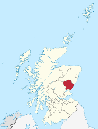
Angus is one of the 32 local government council areas of Scotland, a registration county and a lieutenancy area. The council area borders Aberdeenshire, Dundee City and Perth and Kinross. Main industries include agriculture and fishing. Global pharmaceuticals company GSK has a significant presence in Montrose in the east of the county.

Forfar is the county town of Angus, Scotland and the administrative centre for Angus Council, with a new multi-million pound office complex located on the outskirts of the town. As of 2021, the town has a population of 16,280.

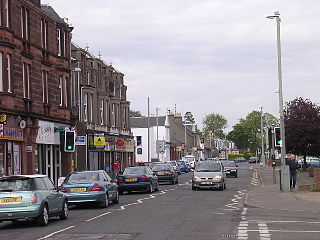
Carnoustie is a town and former police burgh in the council area of Angus, Scotland. It is at the mouth of the Barry Burn on the North Sea coast. In the 2011 census, Carnoustie had a population of 11,394, making it the fourth-largest town in Angus. The town was founded in the late 18th century, and grew rapidly throughout the 19th century due to the growth of the local textile industry. It was popular as a tourist resort from the early Victorian era up to the latter half of the 20th century, due to its seaside location, and is best known for the Carnoustie Golf Links course that often hosts the Open Championship.
Glamis is a small village in Angus, Scotland, located 5 miles (8 km) south of Kirriemuir and 5 miles (8 km) southwest of Forfar. It is the location of Glamis Castle, the childhood home of Queen Elizabeth the Queen Mother.
Monifieth is a town and former police burgh in the council area of Angus, Scotland. It is situated on the north bank of the Firth of Tay on the east coast. In 2016, the population of Monifieth was estimated at 8,110, making it the fifth largest town in Angus.
Liff is a village in Angus, Scotland, situated 4+1⁄2 miles west-northwest of Dundee on a south-facing slope two miles north of the River Tay. It had a population of 568 in 2011.

East Haven is a fishing village in the council area of Angus, Scotland. It is situated 1.5 miles (2 km) east of Carnoustie and 5 miles (8 km) south west of Arbroath. The closest city, Dundee, is 13 miles (21 km) to the west.

Seagate bus station serves Dundee, Scotland. It has eight stances. The Seagate Bus Station is the main stop for journeys leaving the city, while in-town services are operated by Xplore Dundee and do not stop at Dundee Seagate Bus Station.
Barnhill is an area in Dundee, located within the suburb of Broughty Ferry. It is approximately 4½ miles east of Dundee City Centre. Until the late 19th century, Barnhill was a separate village.

Birkhill and neighbouring Muirhead are two small villages in Angus, just to the west of Dundee, Scotland.

Newtyle is a village in the west of Angus, Scotland. It lies eleven miles north of Dundee in the southwest of Strathmore, between Hatton Hill and Newtyle in the Sidlaws. The village sits on gently sloping ground with a northwest aspect. The main communication link is the B954 road. The population was about 800 as of 2004.

The Eassie Stone is a Class II Pictish stone of about the mid 8th century AD in the village of Eassie, Angus, Scotland. The stone was found in Eassie burn in the late 18th century and now resides in a purpose-built perspex building in the ruined Eassie church.

Eassie is a village located along the A94 road in Angus, Scotland. The church in Eassie is dedicated to Saint Fergus, a monk who worked at nearby Glamis. Eassie is noted for the presence of the Eassie Stone, a carved Pictish stone, which resides in the ruins of Eassie Old Church.

Kirkinch, meaning 'kirk (church) on the island' in Scots and Gaelic, is a small village in Angus, Scotland. The 'island' is the knoll on which stand the remains of the late 16th century Nevay Church and its medieval burial ground. Nevay parish is now united with Eassie parish. Originally it was an 'island' of slightly higher land surrounded by boggy country. The village houses are adjacent to the knoll, which is encompassed by the wall of the old churchyard. Some of the earliest history of the local area is represented approximately two kilometres northwest at the village of Eassie, where the Eassie Stone is displayed in a modern transparent shelter in the ruined former parish church; this finely carved Pictish cross-slab probably dates to the first half of the 8th century. The church site at Kirkinch is itself probably of early Christian origin. A simple disc-headed cross-slab found here is on display at the Meffan Institute in Forfar.
Wellbank is a village in Angus, Scotland. It lies approximately three miles north of Dundee, on the B978 road.
Kellas is a village in Angus, Scotland. It lies approximately two miles north of Dundee, on the B978 road.

The Hunter's Hill Stone, otherwise known as the Glamis 1 Stone, is a Class II Pictish standing stone at Hunter's Hill to the south east of Glamis village, Angus, Scotland.
Monikie is a village and civil parish in Angus, Scotland, north-east of Dundee.

Carnoustie High School is a comprehensive secondary school in Carnoustie, Angus, Scotland. Situated to the north of the town, the school serves Carnoustie and surrounding villages, including Barry, Monikie, Newbigging, Craigton, Muirdrum, Panbride and Easthaven.

