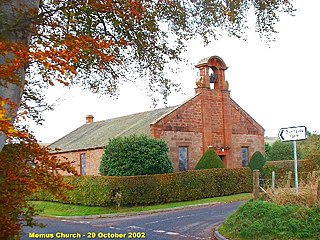
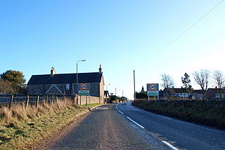
Memus is a small village in Angus, Scotland, north of Kirriemuir. It is home to the Drovers Pub. A story is told of a kelpie at Shielhill Bridge, leaving its cloven hoofprint behind on a stone as a petrosomatoglyph.

Carmyllie is a rural parish in Angus, Scotland. It is situated on high ground between Arbroath, on the coast, and the inland county town of Forfar. The main settlements in the parish are Redford, Greystone, Guynd and Milton of Carmyllie. There is a Church of Scotland church and a primary school. The Elliot Water rises in the west of the parish.
Guthrie is a village in Angus, Scotland, roughly at the centre point of the towns of Arbroath, Brechin and Forfar. The principal building in the village is Guthrie Castle, which has its own public golf course and is a popular venue for events such as markets, parties and weddings. The village of Guthrie is centered on the Guthrie parish church, containing the Guthrie Aisle, built in 1450.
Oathlaw is a village in Angus, Scotland, 4 miles north of Forfar.
Caldhame is a village in Angus, Scotland. It lies approximately 1 mile to the south of Forfar.
Boysack is a village in Angus, Scotland, four miles north of Arbroath.
The Dundee and Arbroath Railway was an early railway in Scotland. It opened in 1838, and used the unusual track gauge of 5 ft 6 in (1,676 mm). In 1848 it changed to standard gauge and connected to the emerging Scottish railway network.
Colliston is a roadside hamlet in Angus, Scotland that is four miles north of Arbroath on the A933 Arbroath to Brechin road, in the parish of St Vigeans.
Marywell is a village in Angus, Scotland, that is north of Arbroath, in the parish of St Vigeans.
Inverarity is a village in Angus, Scotland, UK, on the A90, 6 miles from Forfar, and 7 miles from Dundee. The nearest villages are Gateside, Invereighty, Kincaldrum and Gallowfauld. Inverarity used to be in the old county of Forfarshire. Its name means "creek of Arity".
Kingsmuir is a small village in Angus, one mile south-east of Forfar on the B9128 Carnoustie to Forfar road.
Kirkbuddo is a village in the county of Angus, Scotland, between the towns of Forfar and Carnoustie. Nearby lie the remains of a temporary Roman marching camp dating to the third century AD. A worn type II Pictish stone was found in the kirkyard there in the mid-twentieth century and has subsequently been donated to the Meffan institute in Forfar.
Whigstreet is a village in the county of Angus, Scotland, between the towns of Forfar and Carnoustie. Nearby lie the remains of a temporary Roman marching camp dating to the third century AD.
Greystone is a hamlet in Angus, Scotland. It lies between the towns of Carnoustie and Forfar in the parish of Carmyllie.
Milton of Finavon is a hamlet in Angus, Scotland that lies adjacent to the A90 road on its southern side by the River South Esk. It is approximately 5 miles north-east of Forfar.
Craichie is a hamlet in the parish of Dunnichen, Angus, Scotland. Craichie is three miles south-east of Forfar and two miles south-west of Letham, at a junction on the B9128 Carnoustie to Forfar road.
Gateside is a hamlet in the county of Angus, Scotland. It lies 7 miles south of Forfar on the A90 road.
The Elliot Water is a minor river in Angus, Scotland. The Elliot rises near West Hills in Carmyllie and flows through the parish and village of Arbirlot before reaching the North Sea at Elliot, on the west side of Arbroath. The total length is around 7½ miles or 12 km.
Dun is a rural parish in Angus, Scotland. It contains the House of Dun, home of the Erskine family and is a stop on the Caledonian Railway. It is located on the river South Esk, west of Montrose and east of Brechin. In 1785-7 a bridge was built there across the South Esk. The writer Violet Jacob was born at the House of Dun. William Chalmers Burns, a famous Scottish evangelist was born at Dun in 1815.

Kincaldrum is a hamlet in the county of Angus, Scotland. It lies 1 km northwest of Gateside. Kincaldrum House lies in ruins. A corn mill once stood near the hamlet.

