Hog Island is an island in the wetlands of the Petaluma River in Sonoma County, California, located at 38°09′33″N122°32′18″W near the Marin County line. San Antonio Creek enters the river just west of this island. It is mentioned in a newspaper article from 1914.

Dead Horse Island is an island in the San Joaquin River delta, in California. It is located in Sacramento County, owned by the Wilson Family and managed by Reclamation District 2111. Its coordinates are 38.2290821°N 121.5021750°W.

Little Mandeville Island is a small, mostly submerged island in the San Joaquin River delta, in California. It is part of San Joaquin County, and its coordinates are 38.0104776°N 121.5649522°W. In 1994, 376 acres (152 ha) of former farmland was inundated with water after a levee broke.

Prospect Island is a small island in the San Joaquin River delta, in California. It is part of Solano County, and managed by Reclamation District 1667. Its coordinates are 38.2463030°N 121.6655110°W. It appears on a 1952 USGS map; by 1978, survey maps show it cut diagonally by the Sacramento River Deep Water Ship Channel.

Mallard Island is a small island in Suisun Bay, at the confluence of the Sacramento and San Joaquin rivers. It is part of Contra Costa County, California. Its coordinates are 38°02′31″N121°55′07″W, and the United States Geological Survey measured its elevation as 3 ft (0.91 m) in 1981. It appears in a 1953 USGS map of the area.

Spud Island is a small island of the San Joaquin River, located in the Sacramento–San Joaquin River Delta in northern California. It was once used to farm onions; while it is no longer used for agriculture, it remains inhabited. In the late 20th century it was the site of a county park, which offered camping, fishing and swimming amenities free of charge.

Hog Island is an island in the San Joaquin River, and is one of many islands which constitute the Sacramento–San Joaquin River Delta. It was used for agriculture in the early 20th century, but has now mostly become marsh or submerged land; it remains a spot for fishing, particularly halibut and striped bass.

Day Island is an island at the mouth of the Petaluma River in San Pablo Bay. It is part of Marin County, California. Its coordinates are 38°06′13″N122°29′26″W, and the United States Geological Survey measured its elevation as 105 ft (32 m) in 1981. It appears on a 1951 USGS map of the area. The "1880 History of Marin County" by Alley, Bowen and Co. mentions "a man by name of Day" who "settled on an island in Novato township which has since borne his name" in 1851." To this day, there are still 2 houses on the island, both inhabited.

Deer Island is a former island in Marin County, California, close to the Novato Creek, upstream of San Pablo Bay. It is now the location of Deer Island Preserve. It used to be inhabited by Antonio DeBorba, who diked the nearby wetlands to avoid having to use a boat to get home. The building is still there on the Northeastern part of the island. Deer Island's coordinates are 38°05′52″N122°32′13″W, and the United States Geological Survey measured its elevation as 167 ft (51 m) in 1981. It appears in a 1954 USGS map of the region.

Neils Island is a former island in Sonoma County, California, close to the Petaluma River, upstream of San Pablo Bay. Its coordinates are 38°11′27″N122°34′41″W, and the United States Geological Survey measured its elevation as 82 ft (25 m) in 1981. It appears in a 1954 USGS map of the region.

Wood Island is a former island in Marin County, California, formerly in the Corte Madera Creek but now surrounded by land. Its coordinates are 37°56′37″N122°30′42″W, and the United States Geological Survey measured its elevation as 13 ft (4.0 m) in 1981. It appears in a 1954 USGS map of the region. In the 1960s, its principal owner was Spero Spiliotis. In 1969, the city of Larkspur passed a resolution of intent to annex the island, and in the 1970s, a ferry terminal had been proposed.

Coon Island is an island in the Napa River, upstream of San Pablo Bay. It is in Napa County, California, and managed as part of the Napa-Sonoma Marshes Wildlife Area. Its coordinates are 38°11′33″N122°19′24″W, and the United States Geological Survey measured its elevation as 3 ft (0.91 m) in 1981.
Edgerly Island is an island in the Napa River, upstream of San Pablo Bay. It is in Napa County, California, and managed as part of the Napa-Sonoma Marshes Wildlife Area. Its coordinates are 38°12′12″N122°18′52″W, and the United States Geological Survey measured its elevation as 3 ft (0.91 m) in 1981.

Green Island is an island in the Napa River, upstream of San Pablo Bay. It is in Napa County, California, and managed as part of the Napa-Sonoma Marshes Wildlife Area. Its coordinates are 38°12′09″N122°18′16″W, and the United States Geological Survey measured its elevation as 23 ft (7.0 m) in 1981. It, long with Island No. 1, Island No. 2 and Tubbs Island, are labeled on a 1902 USGS map of the area.
Island No. 1 is a partially submerged island in the Napa River, upstream of San Pablo Bay. It is in Napa and Solano County, California, and parts of it are managed as part of the Napa-Sonoma Marshes Wildlife Area. Its coordinates are 38°08′35″N122°20′40″W, and the United States Geological Survey measured its elevation as 3 ft (0.91 m) in 1981. It, along with Island No. 2, Green Island and Tubbs Island, are labeled on a 1902 USGS map of the area.

Knight Island is a mostly-submerged island in the Napa River, upstream of San Pablo Bay. It is in Solano County, California, and managed as part of the Napa-Sonoma Marshes Wildlife Area. Its coordinates are 38°08′09″N122°17′58″W, and the United States Geological Survey measured its elevation as 3 ft (0.91 m) in 1981.

Tubbs Island is an island in San Pablo Bay. It is in Sonoma County, California, and parts of it are managed as part of the Napa-Sonoma Marshes Wildlife Area. Its coordinates are 38°08′59″N122°25′27″W, and the United States Geological Survey measured its elevation as 0 ft (0 m) in 1981. It, long with Island No. 1, Island No. 2 and Green Island, are labeled on a 1902 USGS map of the area.
Simms Island is a former marsh island in San Francisco Bay. It is in Marin County, California; Its coordinates are 37°57′33″N122°30′18″W, and the United States Geological Survey (USGS) gave its elevation as 13 ft (4.0 m) in 1981. It appears as an island on a USGS map in 1897; it is labeled in a 1954 map, but fully connected to the mainland.

Jakes Island is an island in San Francisco Bay. It is in Marin County, California. Its coordinates are 38°00′47″N122°29′20″W, and the United States Geological Survey gave its elevation as 52 ft (16 m) in 1999. It appears on a 2015 United States Geological Survey map of the area. Egrets can be seen there.

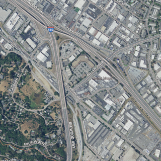
Richardson Island is a former island in San Francisco Bay, in northern California. While it was once surrounded by water and marsh, development of surrounding areas caused it to become completely surrounded by land by the mid-20th century. It is located in Marin County, in the city of Corte Madera. The United States Geological Survey (USGS) gave its elevation as 16 ft (4.9 m) in 1981. It is near the end of Corte Madera Creek, where it flows into San Francisco Bay.