Pacifica is a city in San Mateo County, California, on the coast of the Pacific Ocean between San Francisco and Half Moon Bay.

Milagra Ridge is a 275-acre (111 ha) open space park that is an isolated island ecosystem, located about 7 miles (11 km) south of San Francisco, between the cities of Pacifica and Daly City. It was first inhabited by the Ohlone indigenous people, and was later claimed by Spanish settlers and Mexican ranchers.
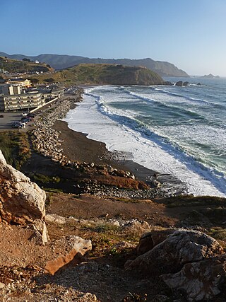
Rockaway Beach is a shoreline area of the Pacific Ocean in the southern portion of Pacifica, California, United States, approximately 7 miles (11 km) south of the city of San Francisco. It is located within a gently curving embayment with direct access via Rockaway Beach Avenue and providing easy access to Highway 1.

Mussel Rock is a rock formation on the coast of San Mateo County, California, offshore from Daly City. It consists of one large and numerous smaller rocks of a type known as a stack, where a headland is eroded unevenly, leaving small islands. The rock itself is located 15 meters from the shore of Mussel Rock Park and stands 18 meters tall.
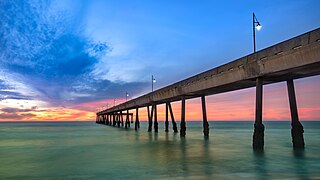
Pacifica State Beach is the southernmost of Pacifica, California's large beaches. It is a 0.75-mile-long (1.21 km) crescent-shaped beach located at the mouth of the San Pedro Valley in downtown Pacifica off State Route 1, in San Mateo County. Over one million people visit this beach annually.

Francisco María Sánchez was a Californio politician, military officer, and ranchero who served as 8th Alcalde of San Francisco and Commandant of the Presidio of San Francisco.

The Sánchez Adobe Park, home to the Sánchez Adobe, is located in Pacifica, California, at 1000 Linda Mar Boulevard, on the north bank of San Pedro Creek, approximately 0.91 miles (1,470 m) from the Pacific Ocean in Linda Mar Valley. The 5.46-acre (2.21 ha) county park, established in 1947 contains the Sanchez Adobe Historical site, designated a National Register Historical District in 1976 and is California registered landmark 391.

Pedro Mountain Road describes a series of historical road crossings of Pedro Mountain, a promontory ridge located between Montara Mountain and the coastal cliffs of Devil's Slide in San Mateo County, California. This Pedro Mountain headland blocks the easy passage of coastal travelers between the Pedro Valley in Pacifica, California and Montara, California. The most prominent of these Pedro Mountain roads was Coastside Boulevard, the 1914 to 1937 coastal highway 57, which remains in use today as part of the trail network of McNee Ranch State Park.

Montara Mountain, positioned between the unincorporated community of Montara, California, to the southwest and the city of Pacifica, California, to the north, forms the northern spur of the Santa Cruz Mountains, a narrow mountain range running the length of the San Francisco Peninsula that separates San Francisco Bay from the Pacific Ocean. Its highest point rises to 1,898 feet (579 m) above sea level. Montara and Pacifica are connected by the Tom Lantos Tunnels, which run through the Mountain.

La Casa Pacifica is a classic California beachfront mansion located in the gated community of Cottons Point Estates/Cypress Shores in the South Orange County beach town of San Clemente, California, and overlooks the Pacific Ocean from its blufftop position. This estate is also known as President Richard Nixon's Western White House, used while living and working outside of the official presidential residence, the White House in Washington, D.C.

McNee Ranch is located in the Santa Cruz Mountains of the United States, near the unincorporated community of Montara, California in San Mateo County. The highest point in the 690-acre ranch rises to 1,898 feet above sea level. An unpaved fire road, the North Peak Access Road, accessible from the Pedro Mountain Road, provides access to the summit by hikers. The mountain has an extensive biodiversity especially on the serpentine soils of the lower slopes where such endangered species as Hickman's potentilla and San Mateo thornmint, Acanthomintha duttonii, are found. On rare occasions light snow has dusted the summit. On clear days the summit provides views of much of the San Francisco Bay Area.
Double Peak is located south of San Marcos, California. The elevation at the summit is 1,646 ft (502 m), and approximately 1,000 feet above the north foot of the mountain. Most trails leading to the summit of Double Peak are classified as "moderately strenuous."
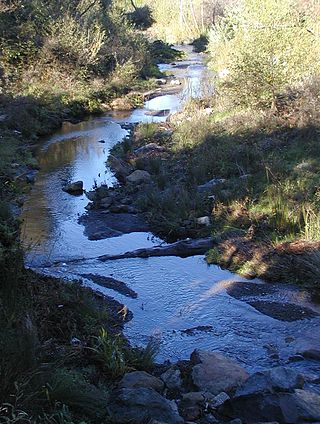
San Pedro Creek is a perennial stream in the City of Pacifica, San Mateo County, California in the San Francisco Bay Area whose tributaries originate on Sweeney Ridge in the Golden Gate National Recreation Area and Montara Mountain in the Santa Cruz Mountains.The creek mainstem flows 2.5 miles (4.0 km) through the San Pedro Valley to its mouth near Shelter Cove of the Pacific Ocean The stream is notable as the 1769 campsite for Gaspar de Portolà before he ascended Sweeney Ridge and discovered San Francisco Bay.

Sweeney Ridge, is a 1,200-acre (5 km2) hilly hiking area of ridges and ravines between San Bruno and Pacifica, California, about a 25-minute drive south from San Francisco. The ridge's 1,200-foot-high summit, covered with coastal scrub and grassland, slopes down to San Francisco Bay on the east and to the Pacific Ocean on the west. The ridge is part of the Golden Gate National Recreation Area. Historically, the ridge is the location of the San Francisco Bay Discovery Site, commemorating the Portolá expedition's first sighting of San Francisco Bay on November 4, 1769.

San Pedro Valley County Park is a San Mateo County park located in Pacifica, California, which includes the headwaters of San Pedro Creek.

The James Rolph was a schooner that transported cargo around the United States West Coast and Hawaii. Built near Eureka, California in 1899, the ship was based in San Francisco and owned by its namesake, shipping executive and future Governor of California, James Rolph.
Hot Springs Mountain is a peak located in the Peninsular Ranges in California. The mountain rises to an elevation of 6,533 feet (1,991 m) and is the highest point in San Diego County. Some snow falls on the mountain peak during winter. It is located in a remote region of the county, 4 miles from the community of Warner Springs, 12 miles from Borrego Springs, and 50 miles from San Diego. The mountain and its immediate surroundings belong to the Los Coyotes Band of Cahuilla and Cupeno Indians. The summit and fire tower can be hiked via the Sukat Road route from the campground. Hikers and campers must pay an entry fee to access the area.

Aravaipa Creek is a drainage between three mountain ranges in southwest Graham County, Arizona – the Galiuro Mountains, the Santa Teresa Mountains and the Pinaleno Mountains. These mountains are part of the high altitude Madrean Sky Islands located in southern Arizona and New Mexico in the United States, and northern Sonora and Chihuahua states in Mexico.

The Palos Verdes Peninsula Land Conservancy (PVPLC) is a non-profit organization that is based on the Palos Verdes Peninsula in southwestern Los Angeles County, California.


