Butchertown, Louisville

Last updated

Butchertown Historic District
BtPicture 003.jpg
Washington Street in Butchertown
USA Kentucky location map.svg
Red pog.svg
Usa edcp location map.svg
Red pog.svg
LocationRoughly bounded by Main, Hancock, Geiger, Quincy Sts., US 42, South Fork of Beargrass Creek, and Baxter Ave., Louisville, Kentucky
Coordinates 38°15′26.96″N85°43′41.53″W / 38.2574889°N 85.7282028°W / 38.2574889; -85.7282028
Area50 acres (20 ha)
Built1873
Architect Adolph Druiding; D.X. Murphy and Company
Architectural styleGreek Revival, Shingle Style, shot-gun
Website louisvillebutchertown.com
NRHP reference No. 76000900 [1]  (original)
100004421  (increase)
Significant dates
Added to NRHPAugust 11, 1976
Boundary increaseSeptember 27, 2019

Butchertown is a neighborhood just east of downtown Louisville, Kentucky, United States, bounded by I-65, Main Street, I-71, Beargrass Creek and Mellwood Avenue.

Contents

The Butchertown Historic District is a 50 acres (20 ha) part which was listed on the National Register of Historic Places in 1976. [1] [2] It includes the 1914-built Beaux Arts Stockyard Exchange Building designed by D.X. Murphy and Brother. [3]

History

The first homes in the area were laid out in the 1820s along the newly completed Louisville to Lexington turnpike, referred to in that stretch as Story Avenue. Two of the first landowners in the area, Whig Party loyalist George Buchanan and Isaac Stewart, had the new community's streets named after major Whig Party members, such as John Quincy Adams, Daniel Webster and Henry Clay. In the 1850s Beargrass Creek was rerouted away from what is now downtown Louisville and through the area, making it an ideal area for butchers and stockyards because the animal remains could be dumped in the creek and such businesses were banned in the downtown area for sanitation reasons. The population swelled as waves of German immigrants entered the area. Bourbon Stockyards, built in 1836, was the first stockyard to locate in Butchertown. A bank is in portions of the original building.[ citation needed ]

Due to the high German population, and resentment of them by supporters of the Know Nothing party, Butchertown was where the "Bloody Monday" riots of August 1855 began as Know Nothings tried to prevent Germans and Irish from voting in an election. The riots killed 22 people.

For the first 100 years of its existence, Butchertown was a thriving residential and industrial area, though other Louisville neighborhoods regarded it as a haven for drunkards and brawlers. However, the area began declining after the great Ohio River flood of 1937 destroyed many of the homes there. Many other homes were demolished for the construction of the Ohio River flood wall, the construction of interstates and the Kennedy Interchange ("Spaghetti Junction") through the area, and the expansion of industrial land into formerly residential areas. Suburbanization continued to bring the residential areas into decline, until the few remaining residents began lobbying for rezoning (the entire area was zoned as industrial), and fixing up vacant and underrepaired houses.

Since the 1990s the area has attracted many young professionals. In recent years, the east Market Street area of downtown Louisville has seen a great deal of revitalization, including the expansion of Waterfront Park, Louisville Slugger Field, and the conversion of empty store fronts into new condominiums. This has helped spur further improvements in Butchertown itself, as many new antique shops and art galleries have opened off the Market Street corridor.

In the 2000s, there were plans as part of the Ohio River Bridges Project to move the Kennedy Interchange further south when it was to be reconfigured by 2018, meaning that more buildings in Butchertown would be razed. However, these plans were scrapped in favor of reconfiguring the interchange in its existing location.[ citation needed ] Furthermore, the project included a second interstate bridge just east of the John F. Kennedy Memorial Bridge that opened as the Abraham Lincoln Bridge on December 6, 2015. The necessity of flyover ramps for the new bridge led to the demolishing of about one-third of Butchertown's David Armstrong Extreme Park, along with a rebuild of facilities on an adjacent property. [4]

Demographics

As of 2000, the population of Butchertown was 975, [5] of which Whites were 82.8%, Blacks were 7.2%, Hispanics were 5.3%, and other races were 4.7%. Males of all races were 60.1% of the population, while females were 39.9%.

Attractions

Thomas Edison House Thomas Edison House Louisville.jpg
Thomas Edison House

Butchertown contains several attractions, including the David Armstrong Extreme Park and Thomas Edison House, a shotgun house near where Thomas Edison lived in 1866 on Washington Street. The remaining front facade of the former early 19th century Heigold House, which features a detailed sketch of important early Whig Party leaders, displays the words "dedicated the greatest man in history, George Washington" etched across its front. The rest of the Fulton Street house has been razed.

Butchertown is also known for its emergence of more modern shops, restaurants, and destination spots. Located on E. Washington Street is Copper & Kings, a brandy and absinthe distillery that offers daily tours and various community events. It is also home to an LGBT night club and a variety of newer eateries.

Lynn Family Stadium, a soccer stadium for Louisville City FC, was planned to open in April 2020 at the eastern edge of the neighborhood, though the opening has since been delayed due to the coronavirus pandemic. It will anchor a larger complex of offices, retail, and hotel that is planned to open at a later date. [6]

See also

Related Research Articles

<span class="mw-page-title-main">David Armstrong Extreme Park</span>

The David Armstrong Extreme Park, formerly called the Louisville Extreme Park, is a 40,000 square foot public skatepark located near downtown Louisville, Kentucky, United States, in the Butchertown neighborhood. It opened on April 5, 2002, and gained national recognition after the release of Tony Hawk's Gigantic Skatepark Tour, in which the park was featured. The park was designed with the input of a local task force. The public skatepark is owned by Louisville Metro Government and operated by Metro Parks.

<span class="mw-page-title-main">Tyler Park, Louisville</span>

Tyler Park is a neighborhood three miles (5 km) southeast of downtown Louisville, Kentucky, USA. It is considered a part of a larger area of Louisville called The Highlands. Near the middle of the neighborhood is a city park of the same name, and many houses in the neighborhood feature park views. The neighborhood boundaries are St Louis Cemetery to the north, Bardstown Road to the east, Eastern Parkway to the south and Beargrass Creek to the west.

<span class="mw-page-title-main">Original Highlands, Louisville</span> United States historic place

The Original Highlands is a historic neighborhood in the Highlands area of Louisville, Kentucky, United States.

<span class="mw-page-title-main">Downtown Louisville</span> Central business district of Louisville, Kentucky, U.S.

Downtown Louisville is the largest central business district in the Commonwealth of Kentucky and the urban hub of the Louisville, Kentucky Metropolitan Area. Its boundaries are the Ohio River to the north, Hancock Street to the east, York and Jacob Streets to the south, and 9th Street to the west. As of 2015, the population of downtown Louisville was 4,700, although this does not include directly surrounding areas such as Old Louisville, Butchertown, NuLu, and Phoenix Hill.

Germantown is a neighborhood three miles southeast of downtown Louisville, Kentucky, USA. Germantown is also a general term for an area of Louisville from the Original Highlands to St Joseph and Bradley neighborhoods that were predominantly settled by Germans. The actual neighborhood is bounded by Barrett Ave, Eastern Parkway, and the South Fork of Beargrass Creek.

<span class="mw-page-title-main">Clifton, Louisville</span> United States historic place

Clifton is a neighborhood east of downtown Louisville, Kentucky USA. Clifton was named because of its hilly location on the Ohio River valley escarpment. Clifton is bounded by I-64, N Ewing Ave, Brownsboro Road, and Mellwood Ave.

Irish Hill is a neighborhood east of downtown Louisville, Kentucky USA. It is bounded by Baxter Avenue to the west, Lexington Road to the north, the middle fork of Beargrass Creek and I-64 to the east. Cave Hill Cemetery is located directly south of Irish Hill. It is in the inner Highlands area of Louisville.

<span class="mw-page-title-main">Kennedy Interchange</span> Highway interchange in Kentucky

The Kennedy Interchange, unofficially, though universally, referred to as Spaghetti Junction, is the intersection of Interstate 64 (I-64), I-65 and I-71 at the northeastern edge of downtown Louisville, Kentucky, United States. It is named for the John F. Kennedy Memorial Bridge, which carries I-65, located immediately to the north of the interchange.

<span class="mw-page-title-main">Crescent Hill, Louisville</span> United States historic place

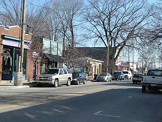
Crescent Hill is a neighborhood four miles (6 km) east of downtown Louisville, Kentucky USA. This area was originally called "Beargrass" because it sits on a ridge between two forks of Beargrass Creek. The boundaries of Crescent Hill are N Ewing Ave to the St. Matthews city limit by Brownsboro Road to Lexington Road. Frankfort Avenue generally bisects the neighborhood.

<span class="mw-page-title-main">Neighborhoods in Louisville, Kentucky</span>

This is a list of official neighborhoods in Louisville, Kentucky. Like many older American cities, Louisville has well-defined neighborhoods, many with well over a century of history as a neighborhood.

<span class="mw-page-title-main">Phoenix Hill, Louisville</span>

Phoenix Hill is a neighborhood of Louisville, Kentucky just east of Downtown. Its boundaries are Market Street to the North, Preston Street to the West, Broadway to the South, and Baxter Avenue to the East. The Phoenix Hill neighborhood, settled before 1850 by German immigrants, is now a rich tapestry of people and a diverse mix of business, industry and residences.

Poplar Level is a neighborhood five miles (8 km) southeast of downtown Louisville, Kentucky, United States. It is part of the larger Camp Zachary Taylor area.

The Point was a thriving 19th century neighborhood in Louisville, Kentucky, east of Downtown Louisville and opposite Towhead Island along the Ohio River. It was also located north of the present day Butchertown area.

<span class="mw-page-title-main">Ohio River Bridges Project</span> Transportation project

The Ohio River Bridges Project was a transportation project in the Louisville metropolitan area involving the reconstruction of the Kennedy Interchange, the completion of two new Ohio River bridges, and the reconstruction of ramps on Interstate 65 between Muhammad Ali Boulevard and downtown Louisville.

<span class="mw-page-title-main">The Highlands, Louisville</span>

The Highlands is an area in Louisville, Kentucky which contains a high density of nightclubs, eclectic businesses, and many upscale and fast food restaurants. It is centered along a three-mile (5 km) stretch of Bardstown Road and Baxter Avenue and is so named because it sits atop a ridge between the middle and south forks of Beargrass Creek. The commercial area extends from the intersection of Bardstown Road and Taylorsville Road/Trevillian Way in the south, to the intersection of Baxter Avenue and Lexington Road in the north, a length of 3.2 miles (5.1 km). A 12-mile (800 m) section of the nearby Barret Avenue also contains many similar businesses. The residential area is separated from other adjacent areas like Germantown and Crescent Hill by the south and north forks of Beargrass Creek. The middle fork runs through Cherokee Park, and the south fork divides Germantown from Tyler Park, after flowing past several cemeteries and undeveloped forests downstream from Joe Creason Park. Due to its large collection of night clubs and restaurants, it is locally known as "Restaurant Row".

<span class="mw-page-title-main">Beargrass Creek (Kentucky)</span> River in the United States

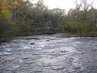
Beargrass Creek is the name given to several forks of a creek in Jefferson County, Kentucky. The Beargrass Creek watershed is one of the largest in the county, draining over 60 square miles (160 km2). It is fairly small, with an average discharge of 103 cubic feet per second at River Road in Louisville.

<span class="mw-page-title-main">Cityscape of Louisville, Kentucky</span>

Louisville, Kentucky is home to numerous structures that are noteworthy due to their architectural characteristics or historic associations, the most noteworthy being the Old Louisville neighborhood, the third largest historic preservation district in the United States. The city also boasts the postmodern Humana Building and an expanding Waterfront Park which has served to remove the former industrial appearance of the riverfront.

<span class="mw-page-title-main">Interstate 64 in Kentucky</span> Interstate Highway in Kentucky, US

Interstate 64 (I-64) in the US state of Kentucky travels for 191 miles (307 km), passing by the major towns and cities of Louisville, Frankfort, Lexington, and Ashland. It has several major junctions with other Interstates, including I-65, I-71, I-264, and I-265 in Louisville and I-75 in Lexington.

<span class="mw-page-title-main">East Market District, Louisville</span>

The East Market District, colloquially referred to as NuLu, is an unofficial district of Louisville, Kentucky, situated along Market Street between downtown to the west, Butchertown to the north, Phoenix Hill to the south, and Irish Hill to the east. The area is home to schools, churches, large and small businesses and some of the city's oldest homes and businesses. A destination since Louisville's founding, Market Street has played host to a variety of businesses throughout the city's history that have drawn Louisvillians for generations to its addresses.

<span class="mw-page-title-main">Parkways of Louisville, Kentucky</span> United States historic place

The parkway system of Louisville, Kentucky, also known as the Olmsted Park System, was designed by the firm of preeminent 19th century landscape architect Frederick Law Olmsted. The 26-mile (42 km) system was built from the early 1890s through the 1930s, and initially owned by a state-level parks commission, which passed control to the city of Louisville in 1942.

References

  1. 1 2 "National Register Information System". National Register of Historic Places . National Park Service. July 9, 2010.
  2. Walter E. Langsam (1976). "National Register of Historic Places Inventory/Nomination: Butchertown Historic District / Butchertown". National Park Service. Archived from the original on January 18, 2023. Retrieved January 17, 2023. With accompanying 54 photos from 1973–1975
  3. Marty Poynter Hedgepeth (July 1982). "National Register of Historic Places Inventory/Nomination". National Park Service . Retrieved February 24, 2018. With 45 photos from 1982.
  4. Shafer, Sheldon (January 1, 2014). "Louisville Extreme Park rebuild getting under way". The Courier-Journal . Louisville, Kentucky. Retrieved February 17, 2016.
  5. "Community Resource Network" . Retrieved November 18, 2005.[ dead link ]
  6. Finley, Marty (October 15, 2019). "As Louisville City FC's era at Slugger Field closes, here's the next stadium milestones to watch". Louisville Business First . Archived from the original on January 30, 2024. Retrieved November 17, 2019.

Further reading