
U.S. Route 150 is a 571-mile (919 km) long northwest–southeast United States highway, signed as east–west. It runs from U.S. Route 6 outside of Moline, Illinois to U.S. Route 25 in Mount Vernon, Kentucky.

Deer Park is a neighborhood four miles southeast of downtown Louisville, Kentucky, USA. Most of the neighborhood was developed from 1890 through the 1920s as a streetcar suburb, with all but six of its 24 subdivisions being developed by 1917, and the last laid out by 1935, although some development west of Norris Place continued after World War II.

Tyler Park is a neighborhood three miles (5 km) southeast of downtown Louisville, Kentucky, USA. It is considered a part of a larger area of Louisville called The Highlands. Near the middle of the neighborhood is a city park of the same name, and many houses in the neighborhood feature park views. The neighborhood boundaries are St Louis Cemetery to the north, Bardstown Road to the east, Eastern Parkway to the south and Beargrass Creek to the west.
Irish Hill is a neighborhood east of downtown Louisville, Kentucky USA. It is bounded by Baxter Avenue to the west, Lexington Road to the north, the middle fork of Beargrass Creek and I-64 to the east. Cave Hill Cemetery is located directly south of Irish Hill. It is in the inner Highlands area of Louisville.

Bonnycastle is a neighborhood four miles (6 km) southeast of downtown Louisville, Kentucky USA. It is considered a part of a larger area of Louisville called The Highlands. Its boundaries are Bardstown Road, Cherokee Road, Eastern Parkway and Speed Avenue.
Highlands–Douglass is a neighborhood five miles (8 km) southeast of downtown Louisville, Kentucky, United States. The neighborhood is bound by Bardstown Road, Speed Avenue, Taylorsville Road, and Cherokee Park. It is considered a part of a larger area of Louisville called The Highlands. It is often simply called Douglass.
Phoenix Hill is a neighborhood of Louisville, Kentucky just east of Downtown. Its boundaries are Market Street to the North, Preston Street to the West, Broadway to the South, and Baxter Avenue to the East. The Phoenix Hill neighborhood, settled before 1850 by German immigrants, is now a rich tapestry of people and a diverse mix of business, industry and residences.
Hawthorne is a neighborhood in eastern Louisville, Kentucky, United States. Its boundaries are Taylorsville Road, Hawthorne Avenue, Bardstown Road and I-264. The land was once part of John Speed's Farmington estate, known for its plantation house built around 1815–16. The neighborhood is primarily residential and was first subdivided in 1909, but saw its fastest grown in the 1920s. It takes its name from Hawthorne Avenue, and most of the other streets are named after writers or poets. Sullivan University is located in the neighborhood.
Hayfield-Dundee is a neighborhood in eastern Louisville, Kentucky. Its boundaries are Dundee Road, Emerson Avenue, Newburg Road, I-264, and Tremont Drive to the east. Prior to subdivision, much of the land had been part of the Hayfield Farm, owned by Dr. Charles Wilkens Short, a founding professor of the University of Louisville medical school.
Gardiner Lane is a neighborhood in eastern Louisville, Kentucky, United States. Its boundaries are Emerson Avenue to the north, Bardstown Road to the east, I-264 to the south, and Tremont Drive to the west. As with surrounding neighborhoods, it was farmland well into the first half of the 1900s. 16 subdivisions were developed from 1913 to 1950.
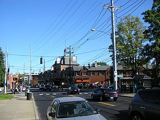
The Highlands is an area in Louisville, Kentucky which contains a high density of nightclubs, eclectic businesses, and many upscale and fast food restaurants. It is centered along a three-mile (5 km) stretch of Bardstown Road and Baxter Avenue and is so named because it sits atop a ridge between the middle and south forks of Beargrass Creek. The commercial area extends from the intersection of Bardstown Road and Taylorsville Road/Trevillian Way in the south, to the intersection of Baxter Avenue and Lexington Road in the north, a length of 3.2 miles (5.1 km). A 1⁄2-mile (800 m) section of the nearby Barret Avenue also contains many similar businesses. The residential area is separated from other adjacent areas like Germantown and Crescent Hill by the south and north forks of Beargrass Creek. The middle fork runs through Cherokee Park, and the south fork divides Germantown from Tyler Park, after flowing past several cemeteries and undeveloped forests downstream from Joe Creason Park. Due to its large collection of night clubs and restaurants, it is locally known as "Restaurant Row".
The Schuster Building is a mixed-use structure at the intersection of Bardstown Road and Eastern Parkway in the Highlands area of Louisville, Kentucky. Added to the National Register of Historic Places in 1980 as a "significant example" of Colonial Revival architecture as applied to commercial buildings, the Schuster building is one of Louisville's most prominent examples of that style.
The Episcopal Church of the Advent is located in Louisville, Kentucky. The congregation began as a Sunday school of Louisville's Christ Church Cathedral in 1870 which met in a store at Broadway and Baxter Avenue and was called "Sunday School of the Advent". In 1872 it moved to Rubel Avenue near Broadway, and was formally organized as a congregation in 1874.
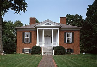
Rose Hill is an antebellum house in Louisville, Kentucky. It was added to the National Register of Historic Places in 1980.

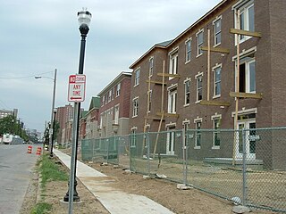
The East Market District, colloquially referred to as NuLu, is an unofficial district of Louisville, Kentucky, situated along Market Street between downtown to the west, Butchertown to the north, Phoenix Hill to the south, and Irish Hill to the east. The area is home to schools, churches, large and small businesses and some of the city's oldest homes and businesses. A destination since Louisville's founding, Market Street has played host to a variety of businesses throughout the city's history that have drawn Louisvillians for generations to its addresses.
Bardstown Road is a major road in Louisville, Kentucky. It is known as "Restaurant Row", which comes from Bardstown Road's many restaurants, bakeries, and cafes, such as: "SuperChefs ", "Ramsi's Cafe on the World ", "Mark's Feed Store ", "Kizito Cookies ", and "Louisville Joe's Coffee Company ". It carries U.S. Route 31E and U.S. Route 150, from the intersection of Baxter Avenue (US 31E) and Broadway (US 150), southeast through Jefferson and Bullitt counties; in Spencer and Nelson counties, the road is named Louisville Road; that road becomes 3rd Street in Bardstown, where US 31E and US 150 split at the intersection with U.S. Route 62.

The Cherokee Triangle is a historic neighborhood in Louisville, Kentucky, USA, known for its large homes displaying an eclectic mix of architectural styles. Its boundaries are Bardstown Road to the southwest, Cherokee Park and Eastern Parkway to the southeast, and Cave Hill Cemetery to the north, and is considered a part of a larger area of Louisville called The Highlands. It is named for nearby Cherokee Park, a 409 acres (1.7 km2) park designed by Frederick Law Olmsted, the designer of New York's Central Park.

James J. Gaffney, most often known as J. J. Gaffney, was an American architect in Louisville, Kentucky.
Belknap is an urban neighborhood three and a half miles east of downtown Louisville, Kentucky, USA. The neighborhood is bound by Bardstown Road, Douglass Boulevard, Dundee Road and Newburg Road. It is part of a larger area of Louisville called the Highlands. Belknap is often described as the neighborhood in the heart of The Highlands.


