Fairmeade, St. Matthews, Kentucky

Last updated
Fairmeade
USA Kentucky location map.svg
Red pog.svg
Fairmeade
Location within the state of Kentucky
Coordinates: 38°14′58″N85°38′7″W / 38.24944°N 85.63528°W / 38.24944; -85.63528 Coordinates: 38°14′58″N85°38′7″W / 38.24944°N 85.63528°W / 38.24944; -85.63528
Country United States
State Kentucky
City St. Matthews
Area
  Total0.1 sq mi (0.2 km2)
  Land0.1 sq mi (0.2 km2)
  Water0.0 sq mi (0.0 km2)
Elevation
525 ft (160 m)
Population
 (2000)
  Total264
  Density4,180.4/sq mi (1,614.1/km2)
Time zone UTC-5 (Eastern (EST))
  Summer (DST) UTC-4 (EDT)
FIPS code 21-26074
GNIS feature ID0491881

Fairmeade is a neighborhood of St. Matthews, Kentucky. The population was 264 at the 2000 census.

Contents

History

Until 2000 Fairmeade was an independent Sixth class city in Jefferson County, Kentucky, United States. Fairmeade was incorporated on October 8, 1953 and dissolved on September 1, 2000. Fairmeade was annexed by St. Matthews on January 8, 2001.

Geography

Fairmeade is located at 38°14′58″N85°38′7″W / 38.24944°N 85.63528°W / 38.24944; -85.63528 (38.249471, -85.635260). [1]

According to the United States Census Bureau, the city has a total area of 0.1 square miles (0.26 km2), all of it land.

Demographics

As of the census [2] of 2000, there were 264 people, 115 households, and 71 families residing in the city. The population density was 4,180.4 inhabitants per square mile (1,614.1/km2). There were 117 housing units at an average density of 1,852.7 per square mile (715.3/km2). The racial makeup of the city was 97.35% White, 1.14% Black or African American, 1.14% Asian, and 0.38% from two or more races.

There were 115 households, out of which 25.2% had children under the age of 18 living with them, 49.6% were married couples living together, 12.2% had a female householder with no husband present, and 37.4% were non-families. 33.0% of all households were made up of individuals, and 10.4% had someone living alone who was 65 years of age or older. The average household size was 2.30 and the average family size was 2.90.

In the city, the population was spread out, with 22.3% under the age of 18, 5.7% from 18 to 24, 27.7% from 25 to 44, 24.2% from 45 to 64, and 20.1% who were 65 years of age or older. The median age was 41 years. For every 100 females, there were 85.9 males. For every 100 females age 18 and over, there were 79.8 males.

The median income for a household in the city was $60,875, and the median income for a family was $74,583. Males had a median income of $61,806 versus $32,500 for females. The per capita income for the city was $33,243. About 5.6% of families and 5.5% of the population were below the poverty line, including none of those under the age of eighteen and 25.0% of those 65 or over.

Related Research Articles

<span class="mw-page-title-main">Laguna Beach, Florida</span> Census-designated place in Florida, United States

Laguna Beach is a census-designated place (CDP) in Bay County, Florida, United States. The population was 3,932 at the 2010 census. It is part of the Panama City–Lynn Haven–Panama City Beach Metropolitan Statistical Area. Laguna Beach was named for the many coastal dune lakes unique to this area of Northwest Florida.

<span class="mw-page-title-main">Three Lakes, Florida</span> CDP in Florida, United States

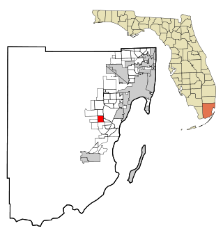
Three Lakes is a census-designated place (CDP) in Miami-Dade County, Florida, United States. The population was 6,955 at the 2000 census. Its name comes from the planned community of Three Lakes, which is located inside Three Lakes CDP boundaries.

<span class="mw-page-title-main">Beechwood Village, Kentucky</span> City in Kentucky, United States

Beechwood Village is a home rule-class city in Jefferson County, Kentucky, United States. The city was formally incorporated by the state assembly in 1950. The population was 1,324 at the 2010 census, up from 1,173 at the 2000 census.

<span class="mw-page-title-main">Bellewood, Kentucky</span> City in Kentucky, United States

Bellewood is a home rule-class city in Jefferson County, Kentucky, United States. The city was formally incorporated by the state assembly in 1950. The population was 321 at the 2010 census.

Broad Fields is a neighborhood of St. Matthews, Kentucky. Broad Fields was a Sixth Class city in Jefferson County, Kentucky, United States. Broad Fields was incorporated on May 24, 1957. Broad Fields was dissolved on July 1, 2000, and annexed by St. Matthews on January 8, 2001. The population was 250 at the 2000 census.

<span class="mw-page-title-main">Brownsboro Village, Kentucky</span> City in Kentucky, United States

Brownsboro Village is a home rule-class city in Jefferson County, Kentucky, United States. The population was 319 at the 2010 census.

Cherrywood Village is a neighborhood and former city in Jefferson County, Kentucky, United States. Cherrywood Village was annexed by the City of St. Matthews in 2001. The population was 327 at the 2000 census.

<span class="mw-page-title-main">Houston Acres, Kentucky</span> City in Kentucky, United States

Houston Acres is a home rule-class city in Jefferson County, Kentucky, United States. The population was 507 at the 2010 census.

<span class="mw-page-title-main">Maryhill Estates, Kentucky</span> City in Kentucky, United States

Maryhill Estates is a home rule-class city in Jefferson County, Kentucky, United States. The population was 179 as of the 2010 census.

<span class="mw-page-title-main">Norwood, Kentucky</span> City in Kentucky, United States

Norwood is a home rule-class city in Jefferson County, Kentucky, United States. The population was 370 at the 2010 census.

Plymouth Village is a neighborhood of St. Matthews, Kentucky a city in Jefferson County, Kentucky, United States. The population was 201 at the 2000 census.

<span class="mw-page-title-main">Richlawn, Kentucky</span> City in Kentucky, United States

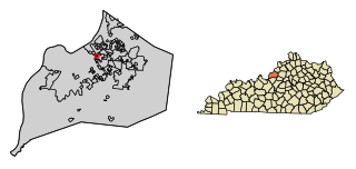
Richlawn is a home rule-class city in eastern Jefferson County, Kentucky, United States. The population was 415 at the 2020 United States Census. The population was 405 at the 2010 census, down from 454 at the 2000 census. It is surrounded by the larger city of St. Matthews.

Springlee is a neighborhood of St. Matthews, Kentucky, an area of Louisville. The population was 426 at the 2000 census. Until 2000 Springlee was an independent Sixth Class city in Jefferson County, Kentucky, United States. Springlee was incorporated on April 25, 1950. Springlee was dissolved on December 5, 2000 and annexed by the City of St. Matthews on January 8, 2001

<span class="mw-page-title-main">St. Regis Park, Kentucky</span> City in Kentucky, United States

St. Regis Park is a home rule-class city in Jefferson County, Kentucky, United States, and a part of the Louisville Metro government. The population was 1,454 as of the 2010 census.

<span class="mw-page-title-main">Watterson Park, Kentucky</span> City in Kentucky, United States

Watterson Park is a home rule-class city in Jefferson County, Kentucky, United States. The population was 976 at the 2010 census.

<span class="mw-page-title-main">Windy Hills, Kentucky</span> City in Jefferson County, Kentucky, United States

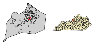
Windy Hills is a home rule-class city, incorporated in 1952, in eastern Jefferson County, Kentucky, United States. The population was 2,385 at the 2010 census.

<span class="mw-page-title-main">Woodlawn Park, Kentucky</span> City in Kentucky, United States

Woodlawn Park is a home rule-class city in Jefferson County, Kentucky, United States. The population was 942 at the 2010 census, down from 1,033 at the 2000 census.

<span class="mw-page-title-main">Oakland, Kentucky</span> City in Kentucky, United States

Oakland is a home rule-class city in Warren County, Kentucky, in the United States. The population was 260 during the year 2000 U.S. Census. It is included in the Bowling Green metropolitan area.

<span class="mw-page-title-main">Mount Vernon, Maryland</span> CDP in Maryland, United States

Mount Vernon is a census-designated place (CDP) in Somerset County, Maryland, United States. The population was 761 at the 2000 census. It is included in the Salisbury, Maryland-Delaware Metropolitan Statistical Area.

<span class="mw-page-title-main">Matthews, Missouri</span> City in Missouri, United States

Matthews is a city in New Madrid County, Missouri, United States. The population was 628 at the 2010 census.

References

  1. "US Gazetteer files: 2010, 2000, and 1990". United States Census Bureau. 2011-02-12. Retrieved 2011-04-23.
  2. "U.S. Census website". United States Census Bureau . Retrieved 2008-01-31.