
Louisville is the most populous city in the Commonwealth of Kentucky, sixth-most populous city in the Southeast, and the 27th-most-populous city in the United States. By land area, it is the country's 24th-largest city, although by population density, it is the 265th most dense city. Louisville is the historical county seat and, since 2003, the nominal seat of Jefferson County, on the Indiana border.

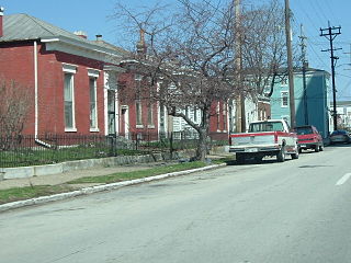
Old Louisville is a historic district and neighborhood in central Louisville, Kentucky, United States. It is the third largest such district in the United States, and the largest preservation district featuring almost entirely Victorian architecture. It is also unique in that a majority of its structures are made of brick, and the neighborhood contains the highest concentration of residential homes with stained glass windows in the U.S. Many of the buildings are in the Victorian-era styles of Romanesque, Queen Anne, Italianate, among others; and many blocks have had few or no buildings razed. There are also several 20th-century buildings from 15 to 20 stories.

East Liberty is a neighborhood in Pittsburgh, Pennsylvania's East End. It is bordered by Highland Park, Morningside, Stanton Heights, Garfield, Friendship, Shadyside and Larimer, and is represented on Pittsburgh City Council by Councilwoman Deborah Gross and Rev. Ricky Burgess. One of the most notable features in the East Liberty skyline is the East Liberty Presbyterian Church, which is an area landmark.

Portland is a neighborhood and former independent town northwest of downtown Louisville, Kentucky. It is situated along a bend of the Ohio River just below the Falls of the Ohio, where the river curves to the north and then to the south, thus placing Portland at the northern tip of urban Louisville. In its early days it was the largest of the six major settlements at the falls, the others being Shippingport and Louisville in Kentucky and New Albany, Clarksville, and Jeffersonville on the Indiana side. Its modern boundaries are the Ohio River along the northwest, north, and northeast, 10th Street at the far east, Market Street on the south, and the Shawnee Golf Course at the far west.

Russell is a neighborhood immediately west of downtown Louisville, Kentucky, U.S.. It is nicknamed "Louisville's Harlem". It was named for renowned African American educator and Bloomfield, Kentucky native, Harvey Clarence Russell Sr.. Its boundaries are West Market Street, 9th Street, West Broadway and I-264.
Shawnee is a neighborhood in western Louisville, Kentucky. Its boundaries are the Ohio River on the West, Bank Street and the Portland neighborhood on the North, I-264 on the East, and West Broadway on the South. Maps sometimes identify the area as Shawneeland.
Downtown Louisville is the largest central business district in the Commonwealth of Kentucky and the urban hub of the Louisville, Kentucky Metropolitan Area. Its boundaries are the Ohio River to the north, Hancock Street to the east, York and Jacob Streets to the south, and 9th Street to the west. As of 2015, the population of downtown Louisville was 4,700, although this does not include directly surrounding areas such as Old Louisville, Butchertown, NuLu, and Phoenix Hill.
Irish Hill is a neighborhood east of downtown Louisville, Kentucky USA. It is bounded by Baxter Avenue to the west, Lexington Road to the north, the middle fork of Beargrass Creek and I-64 to the east. Cave Hill Cemetery is located directly south of Irish Hill. It is in the inner Highlands area of Louisville.
Smoketown is a neighborhood one mile (1.6 km) southeast of downtown Louisville, Kentucky. Smoketown has been a historically black neighborhood since the Civil War. It is the only neighborhood in the city that has had such a continuous presence. Smoketown is bounded by Broadway, CSX railroad tracks, Kentucky Street, and I-65.

This is a list of official neighborhoods in Louisville, Kentucky. Like many older American cities, Louisville has well-defined neighborhoods, many with well over a century of history as a neighborhood.
HOPE VI is a program of the United States Department of Housing and Urban Development. It is intended to revitalize the worst public housing projects in the United States into mixed-income developments. Its philosophy is largely based on New Urbanism and the concept of defensible space.
Park DuValle is a neighborhood southwest of downtown Louisville, Kentucky. It was developed starting in the late-19th century and historically been a predominantly African-American community. Its boundaries are I-264 to the west, the Norfolk Southern Railway tracks to the north, Cypress Street to the east, and Bells Lane and Algonquin Parkway to the south. The neighborhood reflects the presence of several nearby parks, and DuValle Junior High School; all named after Lucie DuValle, the first female principal of a high school in Louisville.

North Heights is a neighborhood in Youngstown, Ohio, located on the city's upper North Side. The neighborhood's name derives from the fact that it sits at a higher elevation than the Wick Park District, Youngstown State University, and Downtown Youngstown. The neighborhood is bordered on the north by Liberty Township, with Gypsy Lane marking the city limit ; Belmont Avenue to the west; Redondo Road and Crandall Park to the south; and Fifth Avenue to the east.

The Highlands is an area in Louisville, Kentucky which contains a high density of nightclubs, eclectic businesses, and many upscale and fast food restaurants. It is centered along a three-mile (5 km) stretch of Bardstown Road and Baxter Avenue and is so named because it sits atop a ridge between the middle and south forks of Beargrass Creek. The commercial area extends from the intersection of Bardstown Road and Taylorsville Road/Trevillian Way in the south, to the intersection of Baxter Avenue and Lexington Road in the north, a length of 3.2 miles (5.1 km). A 1⁄2-mile (800 m) section of the nearby Barret Avenue also contains many similar businesses. The residential area is separated from other adjacent areas like Germantown and Crescent Hill by the south and north forks of Beargrass Creek. The middle fork runs through Cherokee Park, and the south fork divides Germantown from Tyler Park, after flowing past several cemeteries and undeveloped forests downstream from Joe Creason Park. Due to its large collection of night clubs and restaurants, it is locally known as "Restaurant Row".
The Near East Side is a neighborhood located near downtown Columbus, Ohio, made up of several neighborhoods: Mount Vernon, King-Lincoln Bronzeville, Eastgate, Franklin Park, Nelson Park, Olde Towne East, and Woodland Park.
Louisville, Kentucky is home to numerous structures that are noteworthy due to their architectural characteristics or historic associations, the most noteworthy being the Old Louisville neighborhood, the third largest historic preservation district in the United States. The city also boasts the postmodern Humana Building and an expanding Waterfront Park which has served to remove the former industrial appearance of the riverfront.

The East Market District, colloquially referred to as NuLu, is an unofficial district of Louisville, Kentucky, situated along Market Street between downtown to the west, Butchertown to the north, Phoenix Hill to the south, and Irish Hill to the east. The area is home to schools, churches, large and small businesses and some of the city's oldest homes and businesses. A destination since Louisville's founding, Market Street has played host to a variety of businesses throughout the city's history that have drawn Louisvillians for generations to its addresses.
The Clarksdale Housing Complex was a housing project located in Louisville, Kentucky directly east of downtown in the Phoenix Hill neighborhood.
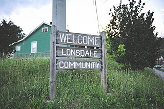
Lonsdale is a neighborhood in Knoxville, Tennessee, United States, located northwest of the city's downtown area. Established in the late-19th century as a land development project, Lonsdale incorporated as a separate city in 1907, and was annexed by Knoxville in 1917. After a period of decline in the latter half of the 20th century, Lonsdale has recently undergone several major revitalization efforts.

Gentrification of Atlanta's inner-city neighborhoods began in the 1970s, and it has continued, at varying levels of intensity, into the present. Many factors have contributed to the city's gentrification. A major increase in gentrification that occurred in the last years of the 20th century has been attributed to the 1996 Summer Olympics. However, during the 2000s, Atlanta underwent a profound transformation demographically, physically, and culturally. Suburbanization, rising prices, a booming economy, and new migrants decreased the city’s black percentage from a high of 67% in 1990 to 54% in 2010. From 2000 to 2010, Atlanta gained 22,763 white residents, 5,142 Asian residents, and 3,095 Hispanic residents, while the city’s black population decreased by 31,678. Much of the city’s demographic change during the decade was driven by young, college-educated professionals: from 2000 to 2009, the three-mile radius surrounding Downtown Atlanta gained 9,722 residents aged 25 to 34 holding at least a four-year degree, an increase of 61%. Between the mid-1990s and 2010, stimulated by funding from the HOPE VI program, Atlanta demolished nearly all of its public housing, a total of 17,000 units and about 10% of all housing units in the city. In 2005, the $2.8 billion BeltLine project was adopted, with the stated goals of converting a disused 22-mile freight railroad loop that surrounds the central city into an art-filled multi-use trail and increasing the city’s park space by 40%. Lastly, Atlanta’s cultural offerings expanded during the 2000s: the High Museum of Art doubled in size; the Alliance Theatre won a Tony Award; and numerous art galleries were established on the once-industrial Westside.


