Related Research Articles

Druid Hills is a home rule-class city in Jefferson County, Kentucky, United States. The population was 308 at the 2010 census. It was incorporated in 1950.
Fern Creek is a historic community in southeastern Jefferson County, Kentucky, United States. The population was 20,009 at the 2008 census. In 2003, The area was annexed to the city of Louisville as part of a merger between the city and Jefferson County's unincorporated communities. Fern Creek was formerly a census-designated place. It is now considered a neighborhood of Louisville. It is located about 12 miles from Downtown Louisville.
Indian Hills is a home rule-class city along the Ohio River in Jefferson County, Kentucky, United States. The population was 2,868 as of the 2010 census. Indian Hills and the nearby cities of Mockingbird Valley, Glenview, and Anchorage have been cited as the most prosperous suburbs of Louisville since the mid-20th century. It was among the highest-income places in the United States as of the 2000 U.S. census.
Maryhill Estates is a home rule-class city in Jefferson County, Kentucky, United States. The population was 179 as of the 2010 census.
Okolona is a former census-designated place (CDP) in southern Louisville/Jefferson County, Kentucky, United States. It is centered on the intersection of Preston Highway and the Outer Loop. The population was 17,807 at the 2000 census. When the government of Jefferson County merged with the city of Louisville, Kentucky in 2003, residents of Okolona also became citizens of Louisville Metro. As a result, Okolona is now a neighborhood within the city limits of Louisville.
Pleasure Ridge Park is a former census-designated place (CDP) in southwest Jefferson County, Kentucky, United States. The population was 26,212 at the 2010 census. In 2003, the area was annexed to the city of Louisville due to a merger between the city and Jefferson County's unincorporated communities. Pleasure Ridge Park is now a neighborhood within the city limits of Louisville.
Shively is a home rule-class city in Jefferson County, Kentucky, United States, and a suburb of Louisville within the Louisville Metro government. As of the 2010 census, the city's population was 15,264, reflecting an increase of 107 (+0.7%) from 15,157 in 2000.
Valley Station is a former census-designated place in southwest Jefferson County, Kentucky, United States. It is known for housing the largest mobile home community in all of Jefferson County. The population was 22,946 at the 2000 census. When the government of Jefferson County merged with the city of Louisville, Kentucky in 2003, residents of Valley Station also became citizens of Louisville Metro. As a result, Valley Station is now a neighborhood within the city limits of Louisville. It was named for its location in the valley between Muldraugh Hill and the Knobs.

The Dixie Highway was a United States automobile highway, first planned in 1914 to connect the US Midwest with the Southern United States. It was part of the National Auto Trail system and was expanded from an earlier Miami to Montreal highway. The final system is better understood as a network of connected paved roads, rather than one single highway. It was constructed and expanded from 1915 to 1929.

The Jefferson Memorial Forest is a forest located in southwest Louisville, Kentucky, in the Knobs region of Kentucky. At 6,500 acres (26 km2), it is the largest municipal urban forest in the United States.
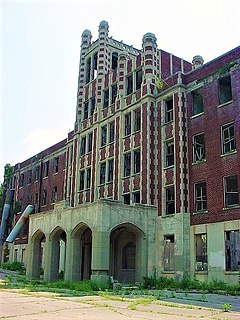
The Waverly Hills Sanatorium is a former sanatorium located in southwestern Louisville/Jefferson County, Kentucky.
Irish Hill is a neighborhood east of downtown Louisville, Kentucky USA. It is bounded by Baxter Avenue to the west, Lexington Road to the north, the middle fork of Beargrass Creek and I-64 to the east. Cave Hill Cemetery is located directly south of Irish Hill. It is in the inner Highlands area of Louisville.
California is a neighborhood in urban Louisville, Kentucky, United States. It is bounded on the north by Broadway, on the east by Ninth Street, on the south by Oak Street, and on the west by Twenty-Sixth Street. There are no written records of the beginning of the neighborhood, but the area was settled by German immigrants around 1849. It is said that the subdivision, initially called Henderson, came to be known as California because it was the "far west" of Louisville.
Hallmark is a small, primarily residential neighborhood in western Louisville, Kentucky, United States founded in 1965. Its boundaries are Cane Run Road to the west, Algonquin Parkway to the north, and Cypress street to the east. The origins of its name are not known. The area sits along Algonquin Park east to west near the border of Louisville and Shively. There are few distinctions that separate Hallmark from the surrounding areas of Park Duvalle or Shively.

Louisville is a city in Jefferson County, in the U.S. state of Kentucky. It is located at the Falls of the Ohio River.
Kosmosdale is a neighborhood in southwestern Louisville, Kentucky located along Dixie Highway near Depot Lane and is named after the Kosmos Cement Company. The Kosmos Cement Company was purchased by the Flintkote Corporation in 1957 and operated as a Division of Flintkote for many years. It is now operated by Cemex, Inc. as a joint venture.
Bethany is a neighborhood of Louisville, Kentucky located on Dixie Highway by Bethany Cemetery.
Johnsontown is a neighborhood of Louisville, Kentucky located along Dixie Highway and Johnsontown Road.
Orell is a neighborhood of Louisville, Kentucky centered along Dixie Highway and Orell Road.

The Cherokee Triangle is a historic neighborhood in Louisville, Kentucky, USA, known for its large homes displaying an eclectic mix of architectural styles. Its boundaries are Bardstown Road to the southwest, Cherokee Park and Eastern Parkway to the southeast, and Cave Hill Cemetery to the north, and is considered a part of a larger area of Louisville called The Highlands. It is named for nearby Cherokee Park, a 409 acres (1.7 km2) park designed by Frederick Law Olmsted, the designer of New York's Central Park.
References
- ^ "HomeTownLocator" . Retrieved 2006-06-10.
