Neighborhoods in Louisville, Kentucky

Last updated
The fountain at St. James Court in Old Louisville St. James Court fountain.jpg
The fountain at St. James Court in Old Louisville

This is a list of official neighborhoods in Louisville, Kentucky . Like many older American cities, Louisville has well-defined neighborhoods, many with well over a century of history as a neighborhood.

Contents

The oldest neighborhoods are the riverside areas of Downtown and Portland (initially a separate settlement), representing the early role of the river as the most important form of commerce and transportation. As the city expanded, peripheral neighborhoods like Butchertown, Phoenix Hill, Russell, Shelby Park, Smoketown and others were developed to house and employ the growing population.

The arrival of the streetcar allowed suburbs to be built further out, such as Beechmont, Belknap, Old Louisville, Shawnee and the Highlands. An interurban rail line in the early 1900s led to communities east of Louisville such as Anchorage and Glenview becoming year-round homes for the rich. Some of Louisville's very rich also moved to mansions along Alta Vista road, in today's Cherokee-Seneca neighborhood.

Pre-merger

Percentage of housing units built before 1940. Dark green represents a 53% to 83% concentration, and is seen in the Old Louisville, Highlands, Crescent Hill, Portland and Butchertown neighborhoods. A 30% to 52% concentration (pea green) can be found throughout many other areas inside I-264. Housing age.gif
Percentage of housing units built before 1940. Dark green represents a 53% to 83% concentration, and is seen in the Old Louisville, Highlands, Crescent Hill, Portland and Butchertown neighborhoods. A 30% to 52% concentration (pea green) can be found throughout many other areas inside I-264.
  1. Algonquin
  2. Auburndale
  3. Audubon
  4. Avondale-Melbourne Heights
  5. Bashford Manor
  6. Beechmont
  7. Belknap
  8. Belmar
  9. Bon Air
  10. Bonnycastle
  11. Bradley
  12. Brownsboro-Zorn
  13. Butchertown
  14. California
  15. Camp Taylor
  16. Cherokee Gardens
  17. Cherokee-Seneca
  18. Cherokee Triangle
  19. Chickasaw
  20. Clifton
  21. Clifton Heights
  22. Cloverleaf
  23. Crescent Hill
  24. Deer Park
  25. Douglass Loop
  26. Downtown
  27. Edgewood
  28. Gardiner Lane
  29. Germantown
  30. Hallmark
  31. Hawthorne
  32. Hayfield Dundee
  33. Hazelwood
  34. Highland Park - Defunct
  35. Highlands
  36. Hikes Point
  37. Irish Hill
  38. Iroquois (Bryn Mawr)
  39. Iroquois (Kenwood)
  40. Iroquois Park
  41. Jacobs
  42. Kenwood Hill
  43. Klondike
  44. Limerick
  45. Lucky Horseshoe
  46. Meriwether
  47. NuLu
  48. Old Louisville
  49. Original Highlands
  50. Paristown Pointe
  51. Park DuValle
  52. Park Hill
  53. Parkland
  54. Phoenix Hill
  55. Poplar Level
  56. Portland
  57. Prestonia
  58. Rockcreek-Lexington Road
  59. Russell
  60. Saint Joseph
  61. Schnitzelburg
  62. Shawnee
  63. Shelby Park
  64. Smoketown
  65. SoBro
  66. South Louisville
  67. Southern Heights
  68. Southland Park
  69. Southside
  70. Standiford - Defunct
  71. Taylor-Berry
  72. Tyler Park
  73. Wilder Park
  74. Wyandotte (also called Oakdale)

Unincorporated places

After merger, unincorporated census designated places in Jefferson County were considered by many (local media for example) to have become neighborhoods of Louisville.

Select unincorporated places, most of which were previously considered CDPs (census-designated places), are:

Other unincorporated places include:

Incorporated places

After merger, incorporated places in Jefferson County became a part of Louisville while retaining their respective small city governments. Most of these small cities are considered neighborhoods of Louisville although the neighborhood boundaries are not necessarily contiguous with the boundaries of the small cities. Listed under St. Matthews are former cities it annexed and thus are now included as its neighborhoods.

Designated as neighborhoods

Some attractions and areas in Louisville are officially designated as neighborhoods.

Historic neighborhoods

See also

Further reading

Related Research Articles

<span class="mw-page-title-main">Jefferson County, Kentucky</span> County in Kentucky, United States

Jefferson County is located in the north central portion of the U.S. state of Kentucky. As of the 2020 census, the population was 782,969. It is the most populous county in the commonwealth.

<span class="mw-page-title-main">Barbourmeade, Kentucky</span> City in Kentucky, United States

Barbourmeade is a home rule-class city in Jefferson County, Kentucky, United States. It was formally incorporated by the state assembly in 1962. The population was 1,216 as of the 2020 census, stagnant from 1,218 at the 2010 census.

<span class="mw-page-title-main">Glenview, Kentucky</span> City in Kentucky, United States

Glenview is a 6th-class city along the southern bank of the Ohio River in northeastern Jefferson County, Kentucky, United States The population was 531 at the 2010 census.

<span class="mw-page-title-main">Indian Hills, Kentucky</span> City in Kentucky, United States

Indian Hills is a home rule-class city along the Ohio River in Jefferson County, Kentucky, United States. The population was 2,860 as of the 2020 census. Indian Hills and the nearby cities of Mockingbird Valley, Glenview, and Anchorage have been cited as Louisville's most prosperous suburbs since the mid-20th century. Indian Hills was among the nation's highest-income places as of the 2000 U.S. census.

<span class="mw-page-title-main">Kingsley, Kentucky</span> City in Kentucky, United States

Kingsley is a home rule-class city in Jefferson County, Kentucky, United States. The population was 381 as of the 2010 census, down from 428 at the 2000 census. It is a suburb of Louisville.

<span class="mw-page-title-main">St. Matthews, Kentucky</span> City in Kentucky, United States

St. Matthews is a city in Jefferson County, Kentucky, United States. It forms part of the Louisville Metro government but is separately incorporated as a home rule-class city. The population was 17,472 at the 2010 census, up from 15,852 at the 2000 census. It is the 23rd-largest city in the state. St. Matthews is one of the state's major shopping areas, home to the fifth-largest mall in Kentucky along with many smaller shopping centers along Shelbyville Road.

<span class="mw-page-title-main">Ten Broeck, Kentucky</span> City in Kentucky, United States

Ten Broeck is a home rule-class city in Jefferson County, Kentucky, United States. The population was 103 at the 2010 census.

<span class="mw-page-title-main">Cherokee Park</span> Municipal park in Louisville, KY, US

Cherokee Park is a 409-acre (166 ha) municipal park located in Louisville, Kentucky, United States and is part of the Louisville Olmsted Parks Conservancy. It was designed in 1891 by Frederick Law Olmsted, the father of landscape architecture along with 18 of Louisville's 123 parks. Beargrass Creek runs through much of the park, and is crossed by numerous pedestrian and automobile bridges.

<span class="mw-page-title-main">Louisville metropolitan area</span> Geographic region surrounding Louisville, KY, USA

The Louisville metropolitan area is the 43rd largest metropolitan statistical area (MSA) in the United States. It had a population of 1,395,855 in 2020 according to the latest official census, and its principal city is Louisville, Kentucky.

<span class="mw-page-title-main">Jerry Abramson</span> Kentucky politician

Jerry Edwin Abramson is an American Democratic politician who was the 55th lieutenant governor of Kentucky. On November 6, 2014, Governor Steve Beshear announced that Abramson would step down from his position as lieutenant governor to accept the job of Director of Intergovernmental Affairs in the Obama White House. He was replaced by former State Auditor Crit Luallen.

<span class="mw-page-title-main">Clifton, Louisville</span> United States historic place

<span class="mw-page-title-main">Crescent Hill, Louisville</span> United States historic place

Crescent Hill is a neighborhood four miles (6 km) east of downtown Louisville, Kentucky USA. This area was originally called "Beargrass" because it sits on a ridge between two forks of Beargrass Creek. The boundaries of Crescent Hill are N Ewing Ave to the St. Matthews city limit by Brownsboro Road to Lexington Road. Frankfort Avenue generally bisects the neighborhood.

Iroquois is a neighborhood on the south side of Louisville, Kentucky, United States. It is split into two parts by Beechmont. From a historical perspective, the northwestern section would be the Bryn Mawr neighborhood and the southeastern section would be the Kenwood neighborhood. The Iroquois neighborhood is roughly bounded by Hazelwood Avenue, Beechmont, Third Street, Kenwood Drive, and Iroquois Park. Located near the Louisville International Airport, residents have frequently complained of noise and challenged airport expansion. The largely residential neighborhood was developed as a suburb after World War II and into the 1950s.

<span class="mw-page-title-main">The Highlands, Louisville</span>

<span class="mw-page-title-main">Beargrass Creek (Kentucky)</span> River in the United States

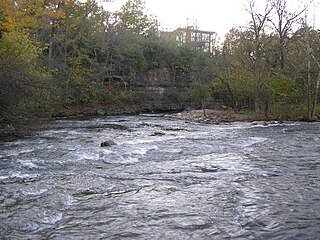
Beargrass Creek is the name given to several forks of a creek in Jefferson County, Kentucky. The Beargrass Creek watershed is one of the largest in the county, draining over 60 square miles (160 km2). It is fairly small, with an average discharge of 103 cubic feet per second at River Road in Louisville.

<span class="mw-page-title-main">Cityscape of Louisville, Kentucky</span>

Louisville, Kentucky is home to numerous structures that are noteworthy due to their architectural characteristics or historic associations, the most noteworthy being the Old Louisville neighborhood, the third largest historic preservation district in the United States. The city also boasts the postmodern Humana Building and an expanding Waterfront Park which has served to remove the former industrial appearance of the riverfront.

<span class="mw-page-title-main">U.S. Route 150 in Kentucky</span> Section of U.S. Numbered Highway in Kentucky, United States

U.S. Route 150 (US 150) in Kentucky is a 121.097-mile-long (194.887 km) east–west highway that runs from the Indiana state line above the Ohio River to US 25/KY 1249 at Mount Vernon.

Belknap is an urban neighborhood three and a half miles east of downtown Louisville, Kentucky, USA. The neighborhood is bound by Bardstown Road, Douglass Boulevard, Dundee Road and Newburg Road. It is part of a larger area of Louisville called the Highlands. Belknap is often described as the neighborhood in the heart of The Highlands.

References

  1. "Standiford". The Encyclopedia of Louisville (1 ed.). 2001.
  2. "Street map of Standiford". ecentral.com. Retrieved 2023-11-18.