Beckley is a neighborhood of Louisville, Kentucky located along North Beckley Station Road and the Chenoweth Run watershed. It is sometimes referred to by its largest subdivision, Lake Forest.
Fairmount is a neighborhood of Louisville, Kentucky located along Bardstown Road and Fairmount Road.
Freys Hill is a neighborhood of the U.S. city of Louisville, Kentucky, located along Freys Hill Road and Westport Road. It is sometimes referred to by its largest subdivision and accompanying shopping center, Springhurst.
Greenwood is a neighborhood of Louisville, Kentucky located along Cane Run Road and Greenwood Road. It is sometimes referred to by its large industrial park and shipping facility, Riverport.
Waverly Hills is a neighborhood in Southwestern Louisville, Kentucky which is centered at Dixie Highway and Pages Lane. It is located in a hilly section of the city, which is part of the larger Knobs Region which extends into southeastern Kentucky. Its boundaries are roughly Stonestreet Road and 3rd Street Road to the south, Dixie Highway to the west, St Andrews Church Road to the north, and Auburndale to the east.
Worthington is a neighborhood of Louisville, Kentucky located along Brownsboro Road and Ballardsville Road. In the 1870s, a toll gate was built on Brownsboro Road at its intersection with Ballardsville Road. In the early 1900s the area was primarily potato farms, but residential development which began in the 1940s accelerated with the opening of Interstates 71 and 265 in the late 1960s.
Berrytown is a neighborhood of Louisville, Kentucky centered along English Station Road. It is named for Alfred Berry, an early settler who bought a 10-acre (40,000 m2) parcel in 1874. The community was then and still is predominantly African-American, once composed of numerous servants of the wealthy residents of nearby Anchorage, Kentucky. Urban renewal redevelopment was planned for the neighborhood in the 1960s, but eventually only expanded the southern part due to resistance by residents.

Eastwood is a neighborhood of Louisville, Kentucky centered along Shelbyville Road and Johnson Road.

English Station is a neighborhood of Louisville, Kentucky centered along Shelbyville Road and the Floyds Fork watershed.
Johnsontown is a neighborhood of Louisville, Kentucky located along Dixie Highway and Johnsontown Road.

Riverside Gardens is a neighborhood of Louisville, Kentucky centered along Campground Road and Lees Lane. In 2007, the first stretch of the proposed 110-mile Louisville Loop bike and pedestrian trail was completed to Lees Lane in Riverside Gardens from Riverview Park. The project included a $2 million bridge over Mill Creek. The concrete trail is expected to be connected to Shawnee Park by spring of 2008. In the future, a wharf and riverfront park is planned for Riverside Gardens.
Long Run is a neighborhood of Louisville, Kentucky located near Shelbyville Road (US 60) and Clark Station Road.
Clark Station is a neighborhood of Louisville, Kentucky located on Clark Station Road.
Medora is a neighborhood of Louisville, Kentucky, centered along Pendleton Road and Medora Road.
Orell is a neighborhood of Louisville, Kentucky centered along Dixie Highway and Orell Road.
Valley Gardens is a neighborhood of Louisville, Kentucky, in the United States. It is centered along Johnsontown Road and Terry Road.
Sylvania is a neighborhood of Louisville, Kentucky located near Terry Road along Sylvania Road.
Valley Downs is a neighborhood of Louisville, Kentucky, USA located along Omar Khayyam Boulevard south of Johnsontown Road.
WNBY is a radio station licensed to Newberry, Michigan broadcasting a classic country format. The station has been owned by Sovereign Communications since 2004, and shares a call-sign and ownership history with sister station WNBY-FM, also based out of Newberry.
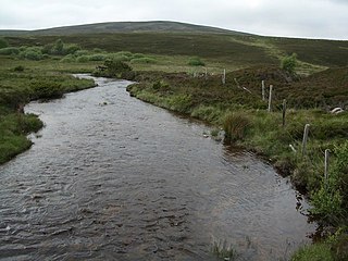
The Dorback Burn is a right-bank tributary of the River Findhorn in northeast Scotland. It emerges from the northeast end of Lochindorb (57.4152°N 3.7038°W) and flows northeast to a point where the A939 road and A940 road meet, where it is joined on its right by the Anaboard Burn. The Dorback then flows north, accompanied by the A940 for several miles until it is joined by the River Divie, which also enters from the right (east). Their combined waters flow on for a couple more miles to pass under the B9007 road and immediately enter the Findhorn (57.5279°N 3.6702°W).
This page is based on this
Wikipedia article Text is available under the
CC BY-SA 4.0 license; additional terms may apply.
Images, videos and audio are available under their respective licenses.
