
Thameslink is a 24-hour mainline route on the British railway network, running from Bedford, Luton, St Albans City, Peterborough, Welwyn Garden City, London Blackfriars and Cambridge via central London to Sutton, Orpington, Sevenoaks, Rainham, Horsham, Three Bridges, Brighton and East Grinstead. The network opened as a through service in 1988, with severe overcrowding by 1998, carrying more than 28,000 passengers in the morning peak. All the services are currently operated by Govia Thameslink Railway.

Wallington railway station is in the London Borough of Sutton in south London. The station, and all trains serving it, is operated by Southern, and is in Travelcard Zone 5. It is between Waddon and Carshalton Beeches, 13 miles 5 chains down the line from London Bridge, measured via Forest Hill.

Mitcham Junction is a National Rail station served by Southern and Thameslink trains, and a Tramlink stop. It is in the London Borough of Merton and is in Travelcard Zone 4.

Blackfriars, also known as London Blackfriars, is a central London railway station and connected London Underground station in the City of London. It provides Thameslink services: local, and regional and limited Southeastern commuter services to South East London and Kent. Its platforms span the River Thames, the only one in London to do so, along the length of Blackfriars Railway Bridge, a short distance downstream from Blackfriars Bridge. There are two station entrances either side of the Thames, along with a connection to the London Underground District and Circle lines.

City Thameslink is a central London railway station within the City of London, with entrances on Ludgate Hill and Holborn Viaduct. The station is on the Thameslink route between Blackfriars to the south and Farringdon to the north.

Streatham railway station is a station in central Streatham in south London. Its main entrance now is on Streatham High Road, and is in Travelcard Zone 3.

Epsom railway station serves the town of Epsom in Surrey, England. It is located off Waterloo Road and is less than two minutes' walk from the town's high street. It is 14 miles 18 chains (22.9 km) down the line from London Waterloo.

Tulse Hill railway station is in the Tulse Hill area of the London Borough of Lambeth in south London, between railway bridges over the A205, South Circular Road and the A215, Norwood Road. It is 5 miles 2 chains (8.1 km) measured from London Victoria. At the moment, there are 4 platforms, each long enough for 8 coaches.

Hackbridge railway station is a railway station at Hackbridge in the London Borough of Sutton in South London. The station is served by Southern and Thameslink. It is in Travelcard Zone 4.

Sutton railway station (sometimes referred to as Sutton (Surrey) on tickets and timetables) is in the London Borough of Sutton in South London and is the main station serving the town of Sutton. It is served by Southern and Thameslink trains, and lies in Travelcard Zone 5, 14 miles 75 chains (14.94 miles, 24.04 km) down the line from London Bridge, measured via Forest Hill.

West Sutton railway station is in the London Borough of Sutton in South London, England. The station is served by Thameslink trains on the Sutton Loop Line. It is in Travelcard Zone 5. It is close to Gander Green Lane, the home ground of Sutton United.
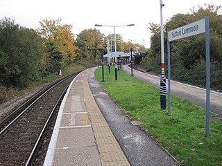
Sutton Common railway station is in Sutton Common in the London Borough of Sutton in South London. The station is served by Thameslink and Southern trains on the Sutton Loop Line. It is in Travelcard Zone 4. It has a single stepped entrance accessible from Sutton Common Road. It is the nearest rail station to the adjoining neighbourhood Benhilton via the footbridge at Angel Hill.
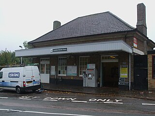
Carshalton Beeches railway station is in south Carshalton in the London Borough of Sutton in south London. The station, and all trains serving it, is operated by Southern, and is in Travelcard Zone 5. It is between Wallington and Sutton, 13 miles 72 chains down the line from London Bridge, measured via Forest Hill.
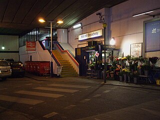
Mill Hill Broadway railway station is on the Midland Main Line in England, serving the suburb of Mill Hill in the London Borough of Barnet, north London. It is 9 miles 28 chains (15.0 km) down the line from St Pancras and is situated between Hendon to the south and Elstree & Borehamwood to the north. Its three-letter station code is MIL.

The Sutton and Mole Valley lines were constructed between 1847 and 1868 by the London, Brighton and South Coast Railway, the London and South Western Railway and the LBSCR-sponsored Horsham, Dorking and Leatherhead Railway.

Horsham railway station serves the town of Horsham in West Sussex, England. It is 37 miles 56 chains (60.7 km) down the line from London Bridge, measured via Redhill, on the Arun Valley Line and the Sutton & Mole Valley Lines, and train services are provided by Southern and Thameslink. Services on the Sutton & Mole Valley Line from London Victoria via Dorking terminate here, as do Thameslink services from Peterborough via London Bridge. The other services continue into the Arun Valley: a half-hourly service from London Victoria to Bognor Regis, and hourly services to Southampton Central or Portsmouth & Southsea. These trains usually divide here with the front (Southampton/Portsmouth) portion travelling fast and the rear half providing stopping services.

St Albans City railway station, also known simply as St Albans, is one of two railway stations serving the city of St Albans in Hertfordshire, England. The 'City' station is the larger of the two, as it is on the better-connected Midland Main Line 19 miles 71 chains (32.0 km) from London St Pancras, being served by Govia Thameslink trains on the Thameslink route.

Dorking railway station is a railway station in Dorking, Surrey, England. Located on the Mole Valley line, it is 22 miles 8 chains (35.6 km) down the line from London Waterloo. The station is one of three that serve the town of Dorking, alongside Dorking Deepdene and Dorking West stations. Dorking and Dorking Deepdene stations are within walking distance of each other and interchange between them on a through ticket is permitted.

Holmwood railway station serves the villages of Beare Green and South Holmwood in Surrey, England, on the Sutton and Mole Valley Lines between Dorking and Horsham, 27 miles 5 chains (43.6 km) from London Waterloo.

Mitcham Eastfields is a railway station in London, United Kingdom, which opened on 2 June 2008. The station is located at Eastfields Road level crossing, in an area previously poorly served by public transport. The nearest station was Mitcham Junction, which along with Mitcham tram stop, was over 1 mile (1.6 km) from the district. It is in fare zone 3.


