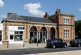
Chalfont & Latimer is a London Underground and National Rail station in Travelcard Zone 8 on the Metropolitan line, in Buckinghamshire. It also serves the Chiltern Railways line to Aylesbury. Chalfont & Latimer station is located just before the junction for trains to Chesham. The station serves Chalfont St Giles, Chalfont St Peter, Little Chalfont and Latimer. It is located in Little Chalfont. It opened as "Chalfont Road" on 8 July 1889 but changed to the present name from 1 November 1915. The station is a good location to alight from to explore the Chess Valley.

Peckham Rye is a railway station in Peckham town centre, South London. It opened on 1 December 1865 for LC&DR trains and on 13 August 1866 for LB&SCR trains. It was designed by Charles Henry Driver (1832–1900), the architect of Abbey Mills and Crossness pumping stations, who also designed the grade II listed Denmark Hill and Battersea Park stations between here and London Victoria. The station is served by Southern, London Overground, Southeastern and Thameslink.

Queens Road Peckham railway station is in the London Borough of Southwark and also serves the area to the east of Peckham, in the London Borough of Lewisham. It is on the South London Line, 2 miles 58 chains (4.4 km) from London Bridge, and trains also go to Croydon via various routes and beyond. It is on the road of that name and is in Travelcard Zone 2.

East Croydon is a railway station and tram stop in Croydon, Greater London, England, and is located in Travelcard Zone 5. At 10 miles 28 chains from London Bridge, it is the 17th busiest station in Britain, was the 10th busiest in 2020–21, and is one of the busiest non-terminal stations in the country. It is one of three railway stations in the London Borough of Croydon with Croydon in their name, the others being West Croydon and South Croydon. A Tramlink tram stop is located immediately outside the main station entrance.

Catford Bridge railway station is on the Mid-Kent Line, serving Hayes line trains from London to Hayes. It lies between Ladywell and Lower Sydenham stations, 7 miles 42 chains (12.1 km) from London Charing Cross and in Travelcard Zone 3. It is adjacent to Catford railway station on the Catford Loop line. The station entrance is on Catford Road, a part of the South Circular Road (A205), and has brick buildings on both platforms, though the up side building is no longer in use by the railway. The station is managed by Southeastern, who operate all trains serving it.

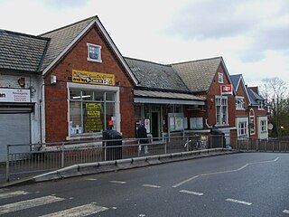
Chorleywood is a London Underground and National Rail station in Travelcard Zone 7 on the Metropolitan line. The village of Chorleywood is in the Three Rivers district of Hertfordshire about 20 miles (32 km) from London. Chorleywood station is also served by Chiltern Railways, which runs trains from London Marylebone station through to Aylesbury.

Beckenham Junction is the main railway and tram station in Beckenham in the London Borough of Bromley, south London. The railway stop is on the Chatham Main Line, 8 miles 53 chains (13.9 km) down the line from London Victoria and situated between Kent House and Shortlands. The tram stop is one of the eastern termini of Tramlink.
Gipsy Hill railway station is in the London Borough of Lambeth in south London. It is situated on the Crystal Palace line, 7 miles 77 chains (12.8 km) measured from London Victoria. The station, and all trains serving it, are operated by Southern, and it is in Travelcard Zone 3.

West Norwood railway station is in the London Borough of Lambeth in West Norwood, South London. It is 7 miles 2 chains (11.3 km) measured from London Victoria. The station, and all trains serving it, are operated by Southern, and it lies in Travelcard Zone 3. Services from Platform 1 go to London Victoria and London Bridge via Tulse Hill. Services from Platform 2 operate to more varied destinations, including West Croydon and London Bridge via Crystal Palace.

Tulse Hill railway station is in the Tulse Hill area of the London Borough of Lambeth in south London, between railway bridges over the A205, South Circular Road and the A215, Norwood Road. It is 5 miles 2 chains (8.1 km) measured from London Victoria. At the moment, there are 4 platforms, each long enough for 8 coaches.

Ladywell railway station is in Ladywell, in the London Borough of Lewisham in south east London, in Travelcard Zone 3. It is 6 miles 62 chains (10.9 km) measured from London Charing Cross.

New Beckenham railway station serves Beckenham in the London Borough of Bromley in south-east London, in Travelcard Zone 4. It is 9 miles 44 chains (15.4 km) measured from London Charing Cross.

Penge East railway station is on the Chatham Main Line in England, serving part of the Penge and Sydenham areas in the London Borough of Bromley, south London. It is 7 miles 15 chains (11.6 km) down the line from London Victoria and is situated between Sydenham Hill and Kent House.

Sydenham Hill railway station is on the Chatham Main Line in England, serving Sydenham Hill, the Kingswood Estate, and Upper Sydenham, in south London. It is 5 miles 57 chains (9.2 km) down the line from London Victoria and is situated between West Dulwich and Penge East. The station and all trains that call are operated by Southeastern, as part of the Bromley South Metro service. Sydenham Hill is in Travelcard Zone 3.
West Dulwich railway station is on the Chatham Main Line in England, serving the West Dulwich area in the London Borough of Southwark, south London. It is located on opposite side of the south circular road from Belair Park, 5 miles 2 chains (8.1 km) down the line from London Victoria and between Herne Hill and Sydenham Hill. The station and all services are operated by Southeastern.

Kent House railway station is on the Chatham Main Line in England, serving part of the Penge and Beckenham areas in the London Borough of Bromley, south London. It is 7 miles 66 chains (12.6 km) down the line from London Victoria and is situated between Penge East and Beckenham Junction. It takes its name from the nearby Kent House farm, the first house in the historic county of Kent after crossing the Surrey border.

Sundridge Park railway station serves Sundridge and Plaistow in the London Borough of Bromley in Greater London, in Travelcard Zone 4. It is 10 miles 12 chains (16.3 km) down the line from Charing Cross.

Ravensbourne railway station is in the London Borough of Bromley in south London. The station adjoins Beckenham Place Park and serves the north edge of Beckenham and Shortlands.
East Dulwich railway station is in the London Borough of Southwark in East Dulwich, south London. The station, and the trains which serve it are operated by Southern, and it is in Travelcard Zone 2, 4 miles 23 chains (6.9 km) down the line from London Bridge. The station was named Champion Hill when it first opened in 1868. It stands where Grove Vale meets Dog Kennel Hill.

Barnes railway station is a Grade II listed station in the London Borough of Richmond upon Thames, in southwest London, and is in Travelcard Zone 3. It is 7 miles 7 chains (11.4 km) down the line from London Waterloo. The station and all trains serving it are operated by South Western Railway.