
Dyfed is a preserved county in southwestern Wales. It is a mostly rural area with a coastline on the Irish Sea and the Bristol Channel.

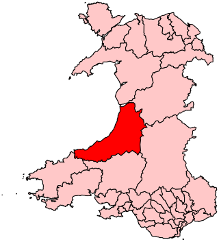
Ceredigion ( ), historically Cardiganshire, is a county in the west of Wales. It borders Gwynedd across the Dyfi estuary to the north, Powys to the east, Carmarthenshire and Pembrokeshire to the south, and the Irish Sea to the west. Aberystwyth is the largest settlement and, together with Aberaeron, is an administrative centre of Ceredigion County Council.

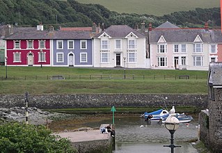
Borth is a village and seaside resort in Ceredigion, Mid Wales; it is located 7 miles (11 km) north of Aberystwyth, on the Ceredigion Coast Path. The community includes the settlement of Ynyslas and the population was 1,399 in 2011. From being largely Welsh-speaking, the village has become anglicised; over 54 per cent of its residents were born in England. According to both the 1991 and 2001 censuses, 43 per cent of the residents of Borth were primarily Welsh-speakers.
Aberaeron, previously anglicised as Aberayron, is a town, community and electoral ward in Ceredigion, Wales. Located on the coast between Aberystwyth and Cardigan, its resident population was 1,274 in the 2021 census.

Lampeter is a town, community and electoral ward in Ceredigion, Wales, at the confluence of the Afon Dulas with the River Teifi. It is the third largest urban area in Ceredigion, after Aberystwyth and Cardigan, and has a campus of the University of Wales Trinity Saint David. At the 2011 Census, the population was 2,970. Lampeter is the smallest university town in the United Kingdom. The university adds approximately 1,000 people to the town's population during term time.

Tregaron is an ancient market town in Ceredigion, Wales. It is sited astride the River Brenig, a tributary of the River Teifi, and is 11 miles (18 km) north-east of Lampeter. According to the 2011 Census, the population of the ward of Tregaron was 1,213 and 67% of the population could speak Welsh; Tregaron is a community covering 33 square miles (85 km2); two-thirds of the population were born in Wales.
Mid Wales, or Central Wales, is a region of Wales, encompassing its midlands, in-between North Wales and South Wales. The Mid Wales Regional Committee of the Senedd covered the unitary authority areas of Ceredigion and Powys and the area of Gwynedd that had previously been the district of Meirionnydd. A similar definition is used by the BBC. The Wales Spatial Plan defines a region known as "Central Wales" which covers Ceredigion and Powys.
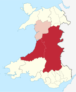
Ceredigion is a parliamentary constituency represented in the House of Commons of the UK Parliament. Created in 1536, the franchise expanded in the late 19th century and on the enfranchisement of women. Its boundaries remained virtually unchanged until 1983. From 1536 until 1885 the area had two seats : a county constituency (Cardiganshire) comprising the rural areas, the other the borough constituency known as the Cardigan District of Boroughs comprising a few separate towns; in 1885 the latter was abolished, its towns and electors incorporated into the former, reduced to one MP. The towns which comprised the Boroughs varied slightly over this long period, but primarily consisted of Cardigan, Aberystwyth, Lampeter and Adpar, the latter now a suburb of Newcastle Emlyn across the Teifi, in Carmarthenshire.

Pen Dinas is a large hill in Penparcau, on the coast of Ceredigion, Wales, upon which an extensive Iron Age, Celtic hillfort is situated. The site can easily be reached on foot from Aberystwyth town centre and is accessible via a series of well marked trails. Boasting a commanding position at the confluence of the River Ystwyth and Afon Rheidol, it has been described as "the pre-eminent hillfort on the Cardigan Bay coast".
Penparcau is a village and electoral ward in Ceredigion, Wales, situated to the south of Aberystwyth.

Ceredigion County Council is the governing body for the county of Ceredigion, since 1996 one of the unitary authorities of Wales. The council's main offices are in Aberaeron.
Cardiganshire County Council was the local government authority for the county of Cardiganshire, Wales, between 1889 and 1974. It was superseded by Dyfed County Council.
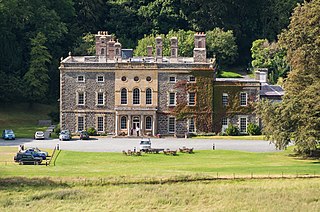
Nanteos is an 18th-century former country house in Llanbadarn-y-Creuddyn, near Aberystwyth, Ceredigion, Wales. A Grade I listed building, it is now a country house hotel. The gardens and parkland surrounding the mansion are listed on the Cadw/ICOMOS Register of Parks and Gardens of Special Historic Interest in Wales.

Aberystwyth is a university and seaside town and a community in Ceredigion, Wales. It is the largest town in Ceredigion and 16 miles (26 km) from Aberaeron, the county's administrative centre. In 2021, the population of the town was 14,640.

Trawsgoed is both a community and an estate in Ceredigion, Wales. The estate is 8 miles (13 km) southeast of Aberystwyth, and has been in the possession of the Vaughan family since 1200. The Vaughans are descended from Collwyn ap Tangno, founder of the fifth noble tribe of North Wales, Lord of Eifionydd, Ardudwy, and part of Llŷn, who had his residence on the site of Harlech Castle.

John Humphreys Davies was a Welsh lawyer, bibliographer and educator. He joined the movement to start a National Library of Wales.

Ceredigion Museum is a museum in Aberystwyth, Ceredigion, Wales.
Aberystwyth Town Council is the community council that governs the ancient borough, town and community of Aberystwyth. For electoral purposes, it is divided into five electoral divisions.
Ceredigion District Council was one of six district-level authorities in the county of Dyfed, Wales, from 1974 until 1996. The district had an identical area to the pre-1974 administrative county of Cardiganshire. From its creation in 1974 the district used the name "Ceredigion" rather than "Cardiganshire", which had been used for the former county council. Further local government reorganisation in 1996 saw Dyfed County Council abolished and Ceredigion become a unitary authority, with the district council taking over county-level services to become Ceredigion County Council.
Ysgubor-y-coed is a community in the northernmost part of Ceredigion, Wales, with a population of 310 as of the 2011 UK census. It includes the villages of Eglwys Fach, Glandyfi, and Furnace, Ceredigion. It is 12 miles (19 km) from Aberystwyth.


