Chain Lake, Washington

Last updated
Chain Lake, Washington
CDP
USA Washington location map.svg
Red pog.svg
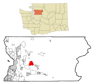
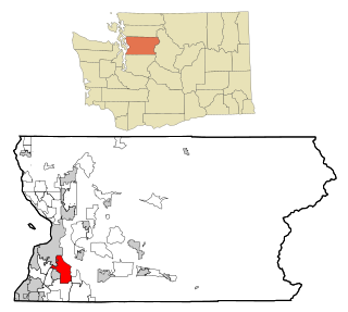
Chain Lake, Washington
Location of Chain Lake, Washington.
Coordinates: 47°54′11″N121°59′13″W / 47.90306°N 121.98694°W / 47.90306; -121.98694 Coordinates: 47°54′11″N121°59′13″W / 47.90306°N 121.98694°W / 47.90306; -121.98694
Country United States
State Washington
County Snohomish
Area
  Total 10.60 sq mi (27.46 km2)
  Land 10.55 sq mi (27.33 km2)
  Water 0.05 sq mi (0.13 km2)
Population (2010)
  Total 3,741
  Density 354.5/sq mi (136.9/km2)
Time zone Pacific (PST) (UTC-8)
  Summer (DST) PDT (UTC-7)
GNIS feature ID 2584957 [1]

Chain Lake is a census-designated place (CDP) in Snohomish County, Washington, United States. The population was 3,741 at the 2010 census.

A census-designated place (CDP) is a concentration of population defined by the United States Census Bureau for statistical purposes only. CDPs have been used in each decennial census since 1980 as the counterparts of incorporated places, such as self-governing cities, towns, and villages, for the purposes of gathering and correlating statistical data. CDPs are populated areas that generally include one officially designated but currently unincorporated small community, for which the CDP is named, plus surrounding inhabited countryside of varying dimensions and, occasionally, other, smaller unincorporated communities as well. CDPs include small rural communities, colonias located along the U.S. border with Mexico, and unincorporated resort and retirement communities and their environs.

Snohomish County, Washington County in the United States

Snohomish County is a county located in the U.S. state of Washington. With an estimated population of 801,633 as of 2017, it is the third-most populous county in Washington, after nearby King and Pierce counties. The county seat and largest city is Everett. The county was created out of Island County on January 14, 1861 and is named for the Snohomish tribe.

2010 United States Census 23rd national census of the United States, taken in 2010

The 2010 United States Census is the twenty-third and most recent United States national census. National Census Day, the reference day used for the census, was April 1, 2010. The census was taken via mail-in citizen self-reporting, with enumerators serving to spot-check randomly selected neighborhoods and communities. As part of a drive to increase the count's accuracy, 635,000 temporary enumerators were hired. The population of the United States was counted as 308,745,538, a 9.7% increase from the 2000 Census. This was the first census in which all states recorded a population of over half a million, as well as the first in which all 100 largest cities recorded populations of over 200,000.

Geography

Chain Lake is located at 47°54′11″N121°59′13″W / 47.90306°N 121.98694°W / 47.90306; -121.98694 (47.903093, -121.987047). [2]

According to the United States Census Bureau, the CDP has a total area of 10.60 square miles (27.46 km²), of which, 10.55 square miles (27.33 km²) of it is land and 0.05 square miles (0.13 km²) of it (0.47%) is water.

United States Census Bureau Bureau of the United States responsible for the census and related statistics

The United States Census Bureau is a principal agency of the U.S. Federal Statistical System, responsible for producing data about the American people and economy. The Census Bureau is part of the U.S. Department of Commerce and its director is appointed by the President of the United States.

Related Research Articles

Lake of the Pines, California census-designated place in California, United States

Lake of the Pines is a census-designated place (CDP) and a gated residential community in Nevada County, California, United States. The population was 3,917 at the 2010 census.

Almanor, California census-designated place in California, United States

Almanor was a census-designated place (CDP) in Plumas County, California, United States. The population was 0 at the 2010 Census. Almanor is located 7 miles (11.3 km) south-southeast of Chester.

Lake Asbury, Florida Census-designated place in Florida, United States

Lake Asbury is an unincorporated community and census-designated place (CDP) in Clay County, Florida, United States. The population was 8,700 at the 2010 census, which calls it Asbury Lake.

Fairfield Beach, Ohio Census-designated place in Ohio, United States

Fairfield Beach is an unincorporated community and census-designated place (CDP) in Fairfield County, Ohio, United States. The population was 1,292 at the 2010 census.

Ames Lake, Washington CDP in Washington, United States

Ames Lake is a census-designated place (CDP) in King County, Washington, United States. The population was 1,486 at the 2010 census.

Lake Marcel-Stillwater, Washington CDP in Washington, United States

Lake Marcel-Stillwater is a census-designated place (CDP) in King County, Washington, United States. The population was 1,277 at the 2010 census.

High Bridge, Washington CDP in Washington, United States

High Bridge is a census-designated place (CDP) in Snohomish County, Washington, United States. The population was 2,994 at the 2010 census. High Bridge includes the Echo Lake community and the former Echo Lake CDP, which was superseded by the larger High Bridge CDP in 2010.

Lake Bosworth, Washington CDP in Washington, United States

Lake Bosworth is a census-designated place (CDP) in Snohomish County, Washington, United States. The population was 667 at the 2010 census.

Lake Roesiger, Washington CDP in Washington, United States

Lake Roesiger is a census-designated place (CDP) in Snohomish County, Washington, United States. The population was 503 at the 2010 census.

North Sultan, Washington CDP in Washington, United States

North Sultan is a census-designated place (CDP) in Snohomish County, Washington, United States. The population was 264 at the 2010 census.

Lake Stickney, Washington CDP in Washington, United States

Lake Stickney is a census-designated place (CDP) in Snohomish County, Washington, United States. The population was 7,777 at the 2010 census. The CDP was known as Paine Field-Lake Stickney prior to 2010. The new Lake Stickney CDP no longer contains the Paine Field airport.

Silver Firs, Washington CDP in Washington, United States

Silver Firs is a census-designated place (CDP) in Snohomish County, Washington, United States. The population was 20,891 at the 2010 census. It lies northeast of the city of Mill Creek. Silver Firs is one of two CDPs that were created out of the former Seattle Hill-Silver Firs CDP in 2010, the other being Eastmont.

Three Lakes, Washington CDP in Washington, United States

Three Lakes is a census-designated place (CDP) in Snohomish County, Washington, United States. The population was 3,184 at the 2010 census.

Verlot, Washington CDP in Washington, United States

Verlot is a census-designated place (CDP) in Snohomish County, Washington, United States. The population was 285 at the 2010 census.

Woods Creek, Washington CDP in Washington, United States

Woods Creek is a census-designated place (CDP) in Snohomish County, Washington, United States. The population was 5,589 at the 2010 census.

Wanakah, New York Census-designated place in New York, United States

Wanakah is a hamlet in the town of Hamburg in Erie County, New York, United States. As of the 2010 census, it had a population of 3,199.

Lake Holm, Washington CDP in Washington, United States

Lake Holm is a census-designated place (CDP) in King County, Washington, United States. The population was 3,221 at the 2010 census.

Shadow Lake, Washington CDP in Washington, United States

Shadow Lake is a census-designated place (CDP) in King County, Washington, United States. The population was 2,262 at the 2010 census.

Wilderness Rim, Washington CDP in Washington, United States

Wilderness Rim is a census-designated place (CDP) in King County, Washington, United States. It lies at an elevation of 1043 ft. The population was 1,523 at the 2010 census.

Cavalero, Washington CDP in Washington, United States

Cavalero is a census-designated place (CDP) in Snohomish County, Washington, United States. The population was 4,660 at the 2010 census. Cavalero was created out of the former West Lake Stevens CDP in 2010.

References