Woods Creek, Washington

Last updated

Woods Creek, Washington
CDP
Snohomish County Washington Incorporated and Unincorporated areas Woods Creek Highlighted.svg
Location of Woods Creek, Washington
Coordinates: 47°53′15″N121°53′50″W / 47.88750°N 121.89722°W / 47.88750; -121.89722
CountryUnited States
State Washington
County Snohomish
Area
  Total12.5 sq mi (32.3 km2)
  Land12.4 sq mi (32.2 km2)
  Water0.0 sq mi (0.1 km2)
Elevation
367 ft (112 m)
Population
 (2020)
  Total6,017
  Density480/sq mi (190/km2)
Time zone UTC-8 (Pacific (PST))
  Summer (DST) UTC-7 (PDT)
FIPS code 53-79825 [1]
GNIS feature ID1852961 [2]

Woods Creek is a census-designated place (CDP) in Snohomish County, Washington, United States. The population was 6,017 at the 2020 census. [3]

Contents

Geography

According to the United States Census Bureau, the CDP has a total area of 12.5 square miles (32.3 km2), of which, 12.4 square miles (32.2 km2) of it is land and 0.04 square miles (0.1 km2) of it (0.24%) is water.

Demographics

As of the census [1] of 2000, there were 4,502 people, 1,518 households, and 1,243 families residing in the CDP. The population density was 362.3 people per square mile (139.8/km2). There were 1,578 housing units at an average density of 127.0/sq mi (49.0/km2). The racial makeup of the CDP was 93.8% White, 0.1% African American, 0.6% Native American, 0.7% Asian, 0.2% Pacific Islander, 2.4% from other races, and 2.2% from two or more races. Hispanic or Latino of any race were 4.6% of the population.

There were 1,518 households, out of which 41.3% had children under the age of 18 living with them, 70.4% were married couples living together, 7.8% had a female householder with no husband present, and 18.1% were non-families. 13.0% of all households were made up of individuals, and 3.5% had someone living alone who was 65 years of age or older. The average household size was 2.97 and the average family size was 3.25.

In the CDP, the age distribution of the population shows 29.9% under the age of 18, 7.0% from 18 to 24, 30.8% from 25 to 44, 25.1% from 45 to 64, and 7.2% who were 65 years of age or older. The median age was 36 years. For every 100 females, there were 101.6 males. For every 100 females age 18 and over, there were 99.4 males.

The median income for a household in the CDP was $66,139, and the median income for a family was $68,424. Males had a median income of $50,756 versus $27,148 for females. The per capita income for the CDP was $25,582. About 2.5% of families and 4.6% of the population were below the poverty line, including 4.3% of those under age 18 and none of those age 65 or over.

Related Research Articles

<span class="mw-page-title-main">Bayview-Montalvin, California</span> Former CDP in California, United States

Bayview-Montalvin is a former census-designated place (CDP) in Contra Costa County, California, United States. The population was 5,004 at the 2000 census.

<span class="mw-page-title-main">Garden Acres, California</span> Census-designated place in California, United States

Garden Acres is a census-designated place (CDP) in San Joaquin County, California, United States. The population was 10,648 at the 2010 census, up from 9,747 at the 2000 census. It is the most populous CDP in San Joaquin County.

<span class="mw-page-title-main">Twin Lakes, California</span> Census-designated place in California, United States

Twin Lakes is a census-designated place (CDP) in Santa Cruz County, California, United States. The population is at an estimated 5,378 as of 2016 which is up by 461 in 2010.

<span class="mw-page-title-main">Charlotte Park, Florida</span> Census-designated place in Florida, United States

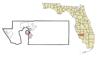
Charlotte Park is a census-designated place (CDP) in Charlotte County, Florida, United States. The population was 2,667 at the 2020 census. It is part of the Sarasota-Bradenton-Punta Gorda Combined Statistical Area.

<span class="mw-page-title-main">Naval Academy, Maryland</span> Census-designated place in Maryland, United States

Naval Academy is a census-designated place (CDP) in Anne Arundel County, Maryland, United States, which covers the campus of the United States Naval Academy. The population was 4,802 at the 2010 census.

<span class="mw-page-title-main">Pine Point, Minnesota</span> Census-designated place in Minnesota, United States

Pine Point is a census-designated place (CDP) in Becker County, Minnesota, United States. The population was 338 at the 2010 census.

<span class="mw-page-title-main">Covedale, Ohio</span> Census-designated place in Ohio, United States

Covedale is a census-designated place (CDP) in Green Township, Hamilton County, Ohio, United States. The population was 6,472 at the 2020 census. The CDP represents the part of the former village of Covedale that was not annexed by the city of Cincinnati in 1930.

<span class="mw-page-title-main">Dry Run, Ohio</span> Census-designated place in Ohio, United States

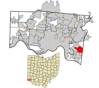
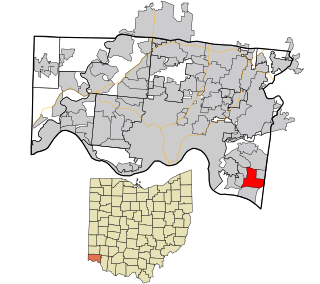
Dry Run is a census-designated place (CDP) in Hamilton County, Ohio, United States. The population was 7,672 at the 2020 census.

<span class="mw-page-title-main">Forestville, Ohio</span> Census-designated place in Ohio, United States

Forestville is a census-designated place (CDP) in Hamilton County, Ohio, United States. The population was 10,615 at the 2020 census.

<span class="mw-page-title-main">Fruit Hill, Ohio</span> Census-designated place in Ohio, United States

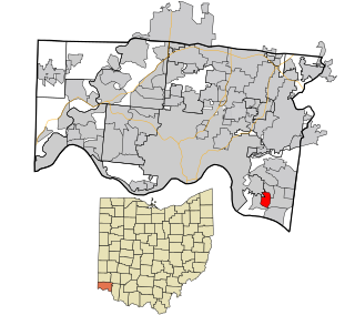
Fruit Hill is a census-designated place (CDP) in Hamilton County, Ohio, United States. The population was 3,748 at the 2020 census.

<span class="mw-page-title-main">Northgate, Ohio</span> Census-designated place in Ohio, United States

Northgate is a census-designated place (CDP) in Colerain Township, Hamilton County, Ohio, United States. The population was 7,277 at the 2020 census.

<span class="mw-page-title-main">Sherwood, Hamilton County, Ohio</span> Census-designated place in Ohio, United States

Sherwood is a census-designated place (CDP) in Hamilton County, Ohio, United States. The population was 3,633 at the 2020 census.

<span class="mw-page-title-main">Turpin Hills, Ohio</span> Census-designated place in Ohio, United States

Turpin Hills is a census-designated place (CDP) in Anderson Township, Hamilton County, Ohio, United States. The population was 5,162 at the 2020 census.

<span class="mw-page-title-main">Murphys Estates, South Carolina</span> CDP in Edgefield County

Murphys Estates is a census-designated place (CDP) in Edgefield County, South Carolina, part of the larger Augusta metropolitan area. The population was 1,719 as of the 2020 census. The community is notable for having the largest number of Irish Traveller Americans in the United States.

<span class="mw-page-title-main">Green Valley, South Dakota</span> CDP in South Dakota, United States

Green Valley is a census-designated place (CDP) and unincorporated community in Pennington County, South Dakota, United States. The population was 1,051 at the 2020 census.

<span class="mw-page-title-main">Three Lakes, Washington</span> CDP in Washington, United States

Three Lakes is a census-designated place (CDP) in Snohomish County, Washington, United States. The population was 3,941 at the 2020 census.

<span class="mw-page-title-main">Piney View, West Virginia</span> Census-designated place in West Virginia, United States

Piney View is a census-designated place (CDP) in Raleigh County, West Virginia, United States. The population was 989 at the 2010 census.

<span class="mw-page-title-main">Loveland Park, Ohio</span> Census-designated place in Ohio, United States

Loveland Park is a census-designated place (CDP) located in Symmes Township, Hamilton County and Deerfield Township, Warren County, in the southwestern part of the U.S. state of Ohio. The CDP is named after the city of Loveland. The population was 1,737 at the 2020 census.

Howland is a census-designated place (CDP) in Penobscot County, Maine, United States. The population was 1,096 at the 2010 census.

<span class="mw-page-title-main">West Seneca (CDP), New York</span> Census-designated place in New York, United States

West Seneca is a hamlet and census-designated place (CDP) in Erie County, New York, United States. The population was 44,711 at the 2010 census. It is part of the Buffalo–Niagara Falls Metropolitan Statistical Area. The CDP corresponds exactly to the area of the town of West Seneca.

References

  1. 1 2 "U.S. Census website". United States Census Bureau . Retrieved January 31, 2008.
  2. "US Board on Geographic Names". United States Geological Survey. October 25, 2007. Retrieved January 31, 2008.
  3. "Census Bureau profile: Woods Creek, Washington". United States Census Bureau. May 2023. Retrieved May 8, 2024.