Arlington Heights, Washington

Last updated

Arlington Heights, Washington
CDP
Snohomish County Washington Incorporated and Unincorporated areas Arlington Heights Highlighted.svg
Location of Arlington Heights, Washington
Coordinates: 48°12′31″N122°3′11″W / 48.20861°N 122.05306°W / 48.20861; -122.05306
CountryUnited States
State Washington
County Snohomish
Area
  Total11.3 sq mi (29.4 km2)
  Land11.3 sq mi (29.4 km2)
  Water0.0 sq mi (0.0 km2)
Elevation
308 ft (94 m)
Population
 (2020)
  Total2,477
  Density220/sq mi (84/km2)
Time zone UTC-8 (Pacific (PST))
  Summer (DST) UTC-7 (PDT)
ZIP code
98223 [1]
Area code 360
FIPS code 53-02620 [2]
GNIS feature ID1515948 [3]

Arlington Heights is a census-designated place (CDP) in Snohomish County, Washington, United States. As of the 2020 census, the population was 2,477, [4] up from 2,284 at the 2010 census.

Contents

Geography

Arlington Heights is located at 48°12′31″N122°3′11″W / 48.20861°N 122.05306°W / 48.20861; -122.05306 (48.208682, -122.052999). [5]

According to the United States Census Bureau, the CDP has a total area of 11.3 square miles (29 km2), all of it land.

Demographics

As of the census [2] of 2000, there were 2,510 people, 838 households, and 682 families living in the CDP. The population density was 221.3 people per square mile (85.4 people/km2). There were 859 housing units at an average density of 75.7 per square mile (29.2/km2). The racial makeup of the CDP was 95.70% White, 0.24% African American, 0.40% Native American, 0.80% Asian, 0.92% from other races, and 1.95% from two or more races. Hispanic or Latino of any race were 1.75% of the population.

There were 838 households, out of which 39.0% had children under the age of 18 living with them, 70.9% were married couples living together, 6.9% had a female householder with no husband present, and 18.6% were non-families. 13.7% of all households were made up of individuals, and 4.5% had someone living alone who was 65 years of age or older. The average household size was 3.00 and the average family size was 3.27.

In the CDP, the age distribution of the population shows 29.5% under the age of 18, 7.0% from 18 to 24, 28.1% from 25 to 44, 26.2% from 45 to 64, and 9.2% who were 65 years of age or older. The median age was 38 years. For every 100 females, there were 101.9 males. For every 100 females age 18 and over, there were 96.8 males.

The median income for a household in the CDP was $60,518, and the median income for a family was $60,590. Males had a median income of $42,440 versus $31,250 for females. The per capita income for the CDP was $22,107. About 8.6% of families and 8.6% of the population were below the poverty line, including 14.1% of those under age 18 and 6.5% of those age 65 or over.

Related Research Articles

<span class="mw-page-title-main">East Richmond Heights, California</span> Unincorporated community in California, United States

East Richmond Heights is an unincorporated community and census-designated place (CDP) in western Contra Costa County, California, United States. Its population was 3,280 at the 2010 census.

<span class="mw-page-title-main">Samsula-Spruce Creek, Florida</span> CDP in Florida, United States

Samsula-Spruce Creek is a census-designated place (CDP) in Volusia County, Florida, United States. The population was 5,047 at the 2010 census. While many households reside here, it is principally an agricultural area west of the cities of Port Orange and New Smyrna Beach.

<span class="mw-page-title-main">Holiday Heights, New Jersey</span> Populated place in Ocean County, New Jersey, US

Holiday Heights is an unincorporated community and census-designated place (CDP) located within Berkeley Township, in Ocean County, in the U.S. state of New Jersey. As of the 2010 United States Census, the CDP's population was 2,099.

<span class="mw-page-title-main">Day Heights, Ohio</span> Census-designated place in Ohio, United States

Day Heights is a census-designated place (CDP) in Clermont County, Ohio, United States. The population was 2,625 at the 2020 census.

<span class="mw-page-title-main">Mount Healthy Heights, Ohio</span> Census-designated place in Ohio, United States

Mount Healthy Heights is a census-designated place (CDP) in Hamilton County, Ohio, United States. The population was 2,918 at the 2020 census.

Arlington Heights is a census-designated place (CDP) in Monroe County, Pennsylvania, United States. The population was 6,331 at the 2020 census. One notable location in Arlington Heights is the Stroud Mall.

Woodland Heights is a census-designated place (CDP) in Venango County, Pennsylvania, United States. The population was 1,402 at the 2000 census.

Lawson Heights is a census-designated place (CDP) in Unity Township, Westmoreland County, Pennsylvania, United States. The population was 2,339 at the 2000 census.

<span class="mw-page-title-main">Ashland Heights, South Dakota</span> CDP in South Dakota, United States

Ashland Heights is a census-designated place (CDP) and unincorporated community in Pennington County, South Dakota, United States. The population was 678 at the 2020 census.

<span class="mw-page-title-main">Longview Heights, Washington</span> CDP in Washington, United States

Longview Heights is a census-designated place (CDP) in Cowlitz County, Washington, United States. The population was 3,851 at the 2010 Census. The CDP is known locally as Columbia Heights.

<span class="mw-page-title-main">Maple Heights-Lake Desire, Washington</span> Census-designated place in Washington, United States

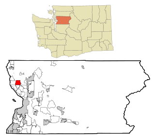
Maple Heights-Lake Desire is a census-designated place (CDP) in King County, Washington, United States. At the 2020 census, the population was 3,873.

<span class="mw-page-title-main">Bay View, Washington</span> CDP in Washington, United States

Bay View is a census-designated place (CDP) in Skagit County, Washington, United States. The population was 696 at the 2010 census. It is included in the Mount Vernon–Anacortes, Washington Metropolitan Statistical Area.

<span class="mw-page-title-main">Lake Cavanaugh, Washington</span> CDP in Washington, United States

Lake Cavanaugh is a census-designated place (CDP) in Skagit County, Washington, United States. The population was 167 at the 2010 census. It is included in the Mount Vernon–Anacortes, Washington Metropolitan Statistical Area.

<span class="mw-page-title-main">Lake Goodwin, Washington</span> Former CDP in Washington, United States

Lake Goodwin is a former census-designated place (CDP) in Snohomish County, Washington, United States. The population was 3,354 at the 2000 census. The CDP was discontinued at the 2010 census.

<span class="mw-page-title-main">Lake Ketchum, Washington</span> CDP in Washington, United States

Lake Ketchum is a census-designated place (CDP) in Snohomish County, Washington, United States. The population was 1,268 at the 2020 census, up from 930 at the 2010 census.

<span class="mw-page-title-main">Lochsloy, Washington</span> CDP in Washington, United States

Lochsloy is a census-designated place (CDP) in Snohomish County, Washington, United States. The population was 2,806 at the 2020 census, up from 2,533 at the 2010 census.

<span class="mw-page-title-main">North Marysville, Washington</span> CDP in Washington, United States

North Marysville is a census-designated place (CDP) in Snohomish County, Washington, United States. The majority of the community and its 20,000 residents were annexed into the city of Marysville in 2009. The population was 108 at the 2010 census.

<span class="mw-page-title-main">Northwest Stanwood, Washington</span> CDP in Washington, United States

Northwest Stanwood is a census-designated place (CDP) in Snohomish County, Washington, United States. The population was 137 at the 2020 census. The CDP was known as North Stanwood prior to the 2010 census, and it included area that is now part of the city of Stanwood.

<span class="mw-page-title-main">Geneva, Washington</span> CDP in Washington, United States

Geneva is an unincorporated area and census-designated place (CDP) in Whatcom County, Washington, United States. The population was 2,321 at the 2010 census.

<span class="mw-page-title-main">Peaceful Valley, Washington</span> CDP in Washington, United States

Peaceful Valley is a census-designated place (CDP) in Whatcom County, Washington, United States, near Kendall. The population was 3,324 at the 2010 census.

References

  1. "Arlington Heights WA ZIP Code". zipdatamaps.com. 2023. Retrieved June 16, 2023.
  2. 1 2 "U.S. Census website". United States Census Bureau . Retrieved January 31, 2008.
  3. "US Board on Geographic Names". United States Geological Survey. October 25, 2007. Retrieved January 31, 2008.
  4. "Census Bureau Profile: Arlington Heights CDP, Washington". United States Census Bureau. Retrieved May 7, 2024.
  5. "US Gazetteer files: 2010, 2000, and 1990". United States Census Bureau. February 12, 2011. Retrieved April 23, 2011.