North Marysville, Washington

Last updated

North Marysville, Washington
CDP
Snohomish County Washington Incorporated and Unincorporated areas North Marysville Highlighted.svg
Location of North Marysville, Washington
Coordinates: 48°5′48″N122°9′18″W / 48.09667°N 122.15500°W / 48.09667; -122.15500
CountryUnited States
State Washington
County Snohomish
Area
  Total1.3 sq mi (3.4 km2)
  Land1.3 sq mi (3.4 km2)
  Water0.0 sq mi (0.0 km2)
Elevation
82 ft (25 m)
Population
 (2010)
  Total108
  Density83.3/sq mi (32.2/km2)
Time zone UTC-8 (Pacific (PST))
  Summer (DST) UTC-7 (PDT)
FIPS code 53-49992 [1]
GNIS feature ID1867623 [2]

North Marysville is a census-designated place (CDP) in Snohomish County, Washington, United States. The majority of the community and its 20,000 residents were annexed into the city of Marysville in 2009. [3] The population was 108 at the 2010 census. [4]

Contents

Geography

North Marysville is located at 48°5′48″N122°9′18″W / 48.09667°N 122.15500°W / 48.09667; -122.15500 (48.096777, -122.155135). [5]

According to the United States Census Bureau, the CDP has a total area of 1.3 square miles (3.4 km2), all of it land.

Demographics

Historical population
CensusPop.Note
1980 15,159
1990 18,71123.4%
2000 21,16113.1%
2010 108−99.5%
U.S. Decennial Census

As of the census [1] of 2000, there were 21,161 people, 7,031 households, and 5,744 families residing in the CDP. The population density was 1,539.6 people per square mile (594.6/km2). There were 7,186 housing units at an average density of 522.8/sq mi (201.9/km2). The racial makeup of the CDP was 89.84% White, 0.71% African American, 1.27% Native American, 3.35% Asian, 0.17% Pacific Islander, 1.75% from other races, and 2.92% from two or more races. Hispanic or Latino of any race were 4.60% of the population.

There were 7,031 households, out of which 44.6% had children under the age of 18 living with them, 67.2% were married couples living together, 9.7% had a female householder with no husband present, and 18.3% were non-families. 13.3% of all households were made up of individuals, and 4.0% had someone living alone who was 65 years of age or older. The average household size was 3.01 and the average family size was 3.27.

In the CDP, the age distribution of the population shows 30.9% under the age of 18, 7.4% from 18 to 24, 32.8% from 25 to 44, 21.2% from 45 to 64, and 7.7% who were 65 years of age or older. The median age was 34 years. For every 100 females, there were 100.1 males. For every 100 females age 18 and over, there were 97.7 males.

The median income for a household in the CDP was $56,699, and the median income for a family was $59,694. Males had a median income of $45,420 versus $29,935 for females. The per capita income for the CDP was $20,842. About 3.6% of families and 4.9% of the population were below the poverty line, including 5.6% of those under age 18 and 3.0% of those age 65 or over.

Related Research Articles

<span class="mw-page-title-main">Millville, California</span> Census-designated place in California, United States

Millville is a census-designated place (CDP) in Shasta County, California, United States. Its population is 724 as of the 2020 census, down from 727 from the 2010 census.

<span class="mw-page-title-main">South Sarasota, Florida</span> Census-designated place in Florida, United States

South Sarasota is a census-designated place (CDP) in Sarasota County, Florida, United States. The population was 4,950 at the 2010 census. It is part of the Bradenton–Sarasota–Venice Metropolitan Statistical Area.

<span class="mw-page-title-main">Papaikou, Hawaii</span> Census-designated place in Hawaii, U.S.

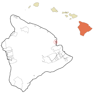
Papaikou is a census-designated place (CDP) in Hawaii County, Hawaii, United States, and is a few miles north of the county seat, Hilo. The population of Papaikou was 1,314 at the 2010 census, down from 1,414 at the 2000 census.

<span class="mw-page-title-main">Algonquin, Maryland</span> Census-designated place in Maryland, United States

Algonquin is a census-designated place (CDP) in Dorchester County, Maryland, United States. The population was 1,241 at the 2010 census. The community was named for the Algonquin people, one of the Native American tribes in the East.

<span class="mw-page-title-main">West Gate, Prince William County, Virginia</span> Unincorporated community & Former Census-designated place in Virginia, United States

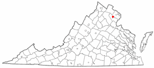
West Gate is an unincorporated community and former census-designated place (CDP) in Prince William County, Virginia, United States. The population was 7,493 at the 2000 census. It contained the now-defunct Sunnybrook Golf Club.

<span class="mw-page-title-main">Lewisville, Washington</span> Census-designated place in Washington, United States

Lewisville is a census-designated place (CDP) in Clark County, Washington, United States. The population was 1,722 at the 2010 census.

<span class="mw-page-title-main">Minnehaha, Washington</span> Census-designated place in Washington, United States

Minnehaha is a census-designated place (CDP) in Clark County, Washington, United States. The population was 9,771 at the 2010 census, up from 7,689 at the 2000 census.

<span class="mw-page-title-main">Parkwood, Washington</span> CDP in Washington, United States

Parkwood is a census-designated place (CDP) in Kitsap County, Washington, United States. The population was 7,126 at the 2010 census.

<span class="mw-page-title-main">Bay View, Washington</span> CDP in Washington, United States

Bay View is a census-designated place (CDP) in Skagit County, Washington, United States. The population was 696 at the 2010 census. It is included in the Mount Vernon–Anacortes, Washington Metropolitan Statistical Area.

<span class="mw-page-title-main">Lake Cavanaugh, Washington</span> CDP in Washington, United States

Lake Cavanaugh is a census-designated place (CDP) in Skagit County, Washington, United States. The population was 167 at the 2010 census. It is included in the Mount Vernon–Anacortes, Washington Metropolitan Statistical Area.

<span class="mw-page-title-main">Arlington Heights, Washington</span> CDP in Washington, United States

Arlington Heights is a census-designated place (CDP) in Snohomish County, Washington, United States. The population was 2,284 at the 2010 census.

<span class="mw-page-title-main">Lake Goodwin, Washington</span> Former CDP in Washington, United States

Lake Goodwin is a former census-designated place (CDP) in Snohomish County, Washington, United States. The population was 3,354 at the 2000 census. The CDP was discontinued at the 2010 census.

<span class="mw-page-title-main">Lake Ketchum, Washington</span> CDP in Washington, United States

Lake Ketchum is a census-designated place (CDP) in Snohomish County, Washington, United States. The population was 930 at the 2010 census.

<span class="mw-page-title-main">Lochsloy, Washington</span> CDP in Washington, United States

Lochsloy is a census-designated place (CDP) in Snohomish County, Washington, United States. The population was 2,533 at the 2010 census.

<span class="mw-page-title-main">Northwest Stanwood, Washington</span> CDP in Washington, United States

Northwest Stanwood is a census-designated place (CDP) in Snohomish County, Washington, United States. The population was 149 at the 2010 census. The CDP was known as North Stanwood prior to the 2010 census, and it included area that is now part of the city of Stanwood.

<span class="mw-page-title-main">Warm Beach, Washington</span> CDP in Washington, United States

Warm Beach is a census-designated place (CDP) in Snohomish County, Washington, United States. The population was 2,437 at the 2010 census.

<span class="mw-page-title-main">Geneva, Washington</span> CDP in Washington, United States

Geneva is an unincorporated area and census-designated place (CDP) in Whatcom County, Washington, United States. The population was 2,321 at the 2010 census.

<span class="mw-page-title-main">Marietta-Alderwood, Washington</span> Place in Washington, United States

Marietta-Alderwood is a census-designated place (CDP) in Whatcom County, Washington, United States. The population was 3,906 at the 2010 census. Parts of Marietta-Alderwood were annexed into Bellingham in 2019.

Woodland is a census-designated place (CDP) in the town of Baileyville, Washington County, Maine, United States. The population was 952 at the 2010 census.

Dexter is a census-designated place (CDP) comprising the main settlement within the town of Dexter in Penobscot County, Maine, United States. The population of the CDP was 2,158 at the 2010 census.

References

  1. 1 2 "U.S. Census website". United States Census Bureau . Retrieved January 31, 2008.
  2. "US Board on Geographic Names". United States Geological Survey. October 25, 2007. Retrieved January 31, 2008.
  3. Boxleitner, Kirk (November 12, 2009). "Marysville City Council votes 6-1 to annex 20,000 residents". Marysville Globe . Retrieved January 24, 2017.
  4. "Incorporated Places and Minor Civil Divisions: Washington". Population Census. 2010 United States Census. July 18, 2011. Retrieved July 27, 2011.[ dead link ]
  5. "US Gazetteer files: 2010, 2000, and 1990". United States Census Bureau. February 12, 2011. Retrieved April 23, 2011.