Alderwood Manor, Washington

Last updated

Alderwood Manor, Washington
CDP
Snohomish County Washington Incorporated and Unincorporated areas Alderwood Manor Highlighted.svg
Location of Alderwood Manor, Washington
Coordinates: 47°48′9″N122°15′31″W / 47.80250°N 122.25861°W / 47.80250; -122.25861
CountryUnited States
State Washington
County Snohomish
Area
  Total4.8 sq mi (12.4 km2)
  Land4.8 sq mi (12.4 km2)
  Water0.0 sq mi (0.0 km2)
Elevation
423 ft (129 m)
Population
 (2020) [1]
  Total10,198
  Density3,194.6/sq mi (1,233.4/km2)
Time zone UTC-8 (PST)
  Summer (DST) UTC-7 (PDT)
ZIP code
98036
Area code 425
FIPS code 53-01185 [2]
GNIS feature ID1511955 [3]

Alderwood Manor is a census-designated place (CDP) in Snohomish County, Washington, United States. The population was 10,198 at the 2020 census. [1] Prior to the 2000 census, Alderwood Manor was counted as part of the Alderwood Manor-Bothell North CDP.

Contents

Geography

According to the United States Census Bureau, the CDP has a total area of 4.8 square miles (12.4 km2).

Parts of Alderwood Manor lie in the Lynnwood MUGA (Municipal Urban Growth Area). Depending on location, buildings in Alderwood Manor may use either Lynnwood, Bothell, or Brier mailing addresses.

History

Former Masonic Temple built in 1919 near 36th Ave W and 196th St Sw in Lynnwood. Mtlyn.jpg
Former Masonic Temple built in 1919 near 36th Ave W and 196th St Sw in Lynnwood.

Alderwood Manor was a community that is now the cities of Lynnwood, Brier, and Mountlake Terrace. Alderwood Manor was a farming community where most residents raised chickens. Alderwood Manor was connected to Everett and Seattle by the interurban trolley system. [4] Most signs of Alderwood have since disappeared but in 2004 Lynnwood's Heritage Park opened. The Heritage Park has some old buildings of the Lynnwood area, such as The Wickers Building, which served as Alderwood's main store and post office from 1919 to the 1960s. Other buildings included Car 55 of the interurban. [5]

In 1979 Lynnwood's largest tourist attraction, the Alderwood Mall was built.

The only Alderwood Manor building still in the same place as when it was built is the old Masonic Temple. The Manor Hardware building (originally used as a schoolhouse in the early 1900s, but which had been vacant for many years) was demolished in 2015. [6] Both locations are just off of 196th St SW in Lynnwood. Some private homes still stand in the area as well.

Demographics

Historical population
CensusPop.Note
1980 16,524
1990 22,94538.9%
2000 15,329−33.2%
2010 8,442−44.9%
2020 10,19820.8%
U.S. Decennial Census [7]
2020 Census [1]

2000 census

As of the census [2] of 2000, there were 15,329 people, 5,558 households, and 4,090 families residing in the CDP. The population density was 3,194.6 people per square mile (1,233.0/km2). There were 5,743 housing units at an average density of 1,196.8/sq mi (462.0/km2). The racial makeup of the CDP was 52.12% White, 14.62% African American, 0.86% Native American, 9.82% Asian, 0.46% Pacific Islander, 1.59% from other races, and 3.53% from two or more races. Hispanic or Latino of any race were 26.97% of the population.

There were 5,558 households, out of which 40.6% had children under the age of 18 living with them, 60.4% were married couples living together, 9.2% had a female householder with no husband present, and 26.4% were non-families. 19.4% of all households were made up of individuals, and 5.9% had someone living alone who was 65 years of age or older. The average household size was 2.75 and the average family size was 3.17.

In the CDP, the age distribution of the population shows 28.1% under the age of 18, 7.1% from 18 to 24, 34.5% from 25 to 44, 21.6% from 45 to 64, and 8.7% who were 65 years of age or older. The median age was 35 years. For every 100 females, there were 98.3 males. For every 100 females age 18 and over, there were 96.4 males.

The median income for a household in the CDP was $61,199, and the median income for a family was $68,679. Males had a median income of $45,807 versus $33,099 for females. The per capita income for the CDP was $24,012. About 2.4% of families and 3.6% of the population were below the poverty line, including 4.0% of those under age 18 and 2.4% of those age 65 or over.

Notable residents

Related Research Articles

<span class="mw-page-title-main">Stanford, California</span> Census-designated place in Santa Clara County, California, US

Stanford is a census-designated place (CDP) in the northwest corner of Santa Clara County, California, United States. It is the home of Stanford University. The population was 21,150 at the 2020 census.

<span class="mw-page-title-main">Sherwood Manor, Connecticut</span> Census-designated place in Connecticut, United States

Sherwood Manor is a census-designated place (CDP) within the town of Enfield in Hartford County, Connecticut, United States. The population was 5,410 at the 2010 census.

Saybrook Manor is a community and census-designated place (CDP) in Old Saybrook, a town in Middlesex County, Connecticut, United States. The population was 1,127 at the 2020 census. The Saybrook Manor section is generally the area south of U.S. Route 1 between the Westbrook town line and the Oyster River.

<span class="mw-page-title-main">Wilmington Manor, Delaware</span> CDP in Delaware, United States

Wilmington Manor is a census-designated place (CDP) in north-eastern New Castle County, Delaware, United States. The population was 7,889 at the 2010 census.

<span class="mw-page-title-main">Naples Manor, Florida</span> Census-designated place in Florida

Naples Manor is a census-designated place (CDP) in Collier County, Florida, United States. The population was 5,132 at the 2020 census, down from 5,562 at the 2010 census. It is part of the Naples–Marco Island Metropolitan Statistical Area.

Seminole Manor is a census-designated place (CDP) in Palm Beach County, Florida, United States. The CDP was developed in the late 1950s, with the majority of houses built in 1958 and 1959. It is part of the Miami metropolitan area of South Florida. The population was 2,562 at the 2020 US census.

<span class="mw-page-title-main">Zia Pueblo, New Mexico</span> CDP in New Mexico, United States

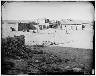
Zia Pueblo is a census-designated place (CDP) in Sandoval County, New Mexico, United States. The population was 646 at the 2000 census, with 310 males and 336 females. The pueblo after which the CDP is named is included within the CDP; it is listed on the National Register of Historic Places.

<span class="mw-page-title-main">Hampton Manor, New York</span> CDP in New York, United States

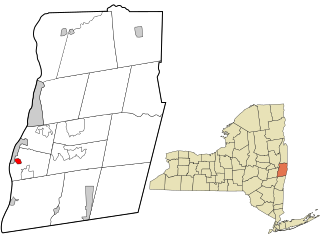
Hampton Manor is a census-designated place in the town of East Greenbush in Rensselaer County, New York, United States. The population was 5,423 at the 2020 census.

<span class="mw-page-title-main">Mastic, New York</span> Hamlet and census-designated place in New York, United States

Mastic is a hamlet and a census-designated place (CDP) in the southeastern part of the town of Brookhaven in central Suffolk County, New York, United States. The population was 15,481 at the 2010 census.

<span class="mw-page-title-main">Meridian, Pennsylvania</span> Census-designated place in Pennsylvania, United States

Meridian is a census-designated place (CDP) in Butler County, Pennsylvania, United States. The population was 3,881 at the 2010 census.

<span class="mw-page-title-main">Nixon, Pennsylvania</span> Census-designated place in Pennsylvania, United States

Nixon is a census-designated place (CDP) in Penn Township, Butler County, Pennsylvania, United States. The population was 1,373 at the 2010 census.

<span class="mw-page-title-main">Wickerham Manor-Fisher, Pennsylvania</span> Census-designated place in Pennsylvania, United States

Wickerham Manor-Fisher is a census-designated place (CDP) in Washington County, Pennsylvania, United States. The population was 1,728 at the 2010 census.

<span class="mw-page-title-main">Groveton, Virginia</span> Census-designated place in Virginia, United States

Groveton is a census-designated place (CDP) in Fairfax County, Virginia, United States. The population was 14,598 at the 2010 census, down from 21,296 in 2000 due to a reduction in area. Located south of the city of Alexandria, it encompasses numerous neighborhoods including Groveton, Bucknell Manor, Stoneybrooke, and portions of Hollin Hills. Huntley Meadows Park, Fairfax County's largest park, is located in the southwest part of the CDP.

<span class="mw-page-title-main">Brier, Washington</span> City in Washington, United States

Brier is a city in Snohomish County, Washington, United States. It is bordered by Mountlake Terrace to the west, Lynnwood to the north, Bothell to the east, and Lake Forest Park to the south. The population was 6,560 at the 2020 census.

<span class="mw-page-title-main">Lynnwood, Washington</span> City in Washington, United States

Lynnwood is a city in Snohomish County, Washington, United States. The city is part of the Seattle metropolitan area and is located 16 miles (26 km) north of Seattle and 13 miles (21 km) south of Everett, near the junction of Interstate 5 and Interstate 405. It is the fourth-largest city in Snohomish County, with a population of 38,568 in the 2020 U.S. census.

<span class="mw-page-title-main">Martha Lake, Washington</span> CDP in Washington, United States

Martha Lake is a census-designated place (CDP) in Snohomish County, Washington, United States. The population was 21,129 at the 2020 census. It lies west of Mill Creek and northeast of Lynnwood, near the lake of the same name.

<span class="mw-page-title-main">Picnic Point-North Lynnwood, Washington</span> Former CDP in Washington, United States

Picnic Point-North Lynnwood is a former census-designated place (CDP) in Snohomish County, Washington, United States. The population was 22,953 at the 2000 census. For the 2010 census, the CDP was separated into Picnic Point and North Lynnwood, with a small part going to the new Meadowdale CDP.

<span class="mw-page-title-main">Marietta-Alderwood, Washington</span> Place in Washington, United States

Marietta-Alderwood is a census-designated place (CDP) in Whatcom County, Washington, United States. The population was 3,906 at the 2010 census. Parts of Marietta-Alderwood were annexed into Bellingham in 2019, while the rest remains an unincorporated area.

<span class="mw-page-title-main">Eagle Lake, Wisconsin</span> CDP in Wisconsin, United States

Eagle Lake is a census-designated place (CDP) in the town of Dover, Racine County, Wisconsin, United States. The population was 1,251 at the 2020 census.

Lynnwood-Pricedale is a census-designated place (CDP) in Fayette and Westmoreland counties in the Pennsylvania. The population was 2,031 at the 2010 census, down from 2,168 at the 2000 census. The community of Lynwood is located in Fayette County's Washington Township, while Pricedale is part of Westmoreland County's Rostraver Township.

References

  1. 1 2 3 "Explore Census Data". United States Census Bureau . Retrieved June 22, 2022.
  2. 1 2 "U.S. Census website". United States Census Bureau . Retrieved January 31, 2008.
  3. "US Board on Geographic Names". United States Geological Survey. October 25, 2007. Retrieved January 31, 2008.
  4. "Interurban Car No. 55". www.lynnwoodwa.gov. Retrieved November 7, 2021.
  5. "Heritage Park". www.lynnwoodwa.gov. Retrieved November 7, 2021.
  6. "Manor Hardware Building Torn Down". Lynnwood Today. My Neighborhood News Network. April 8, 2015. Retrieved April 10, 2015.
  7. United States Census Bureau. "Census of Population and Housing" . Retrieved July 26, 2013.
  8. "Nixon brother "paid to do nothing," says wife of library site hunter". The Lowell Sun . Associated Press. January 2, 1974. p. 11. Retrieved July 2, 2018 via Newspapers.com. Lock-green.svg